用于小天体三维地形测绘和导航的混合固态激光雷达系统成像建模与误差分析

IF 5 2区 物理与天体物理 Q1 OPTICS
Huan Xie , Qingfan Zhang , Xiongfeng Yan , Yanmin Jin , Jie Chen , Yuanting Xi , Jun Xie , Yuechao Ma , Feihu Zhu , Xiaohua Tong
{"title":"用于小天体三维地形测绘和导航的混合固态激光雷达系统成像建模与误差分析","authors":"Huan Xie ,&nbsp;Qingfan Zhang ,&nbsp;Xiongfeng Yan ,&nbsp;Yanmin Jin ,&nbsp;Jie Chen ,&nbsp;Yuanting Xi ,&nbsp;Jun Xie ,&nbsp;Yuechao Ma ,&nbsp;Feihu Zhu ,&nbsp;Xiaohua Tong","doi":"10.1016/j.optlastec.2025.113933","DOIUrl":null,"url":null,"abstract":"<div><div>Accurate imaging models and error analyses are critical for evaluating and calibrating LiDAR systems, particularly in high-precision 3D terrain mapping and navigation applications. This study focuses on a hybrid solid-state LiDAR system that integrates a 32 × 32 single-photon avalanche diode (SPAD) array, dual fast steering mirrors (FSMs), and a grating-based beam splitter to achieve high-speed, high-resolution imaging under dynamic asteroid conditions. This optical configuration, characterized by multi-stage beam deflection and array-based detection, presents significant challenges for accurate LiDAR modeling and systematic error analysis. To address these optical complexities, an imaging model was developed based on the system’s single-photon detection characteristics, scanning modes and multi-beam splitting. Specifically, a pixel-wise range estimation method was proposed based on histogram peak extraction, significantly enhancing measurement precision for single-photon detection under high frame-rate operation, thus enabling accurate 3D coordinate reconstruction from raw measurements under fast scanning conditions. Additionally, a Monte Carlo-based error analysis framework was established to quantify the impacts of eleven systematic error sources, including range deviations, FSM angular errors, and internal timing uncertainties. A pixel-wise consistency evaluation across all 1024 SPAD pixels was also conducted, providing detailed insights into error propagation and revealing critical pixel-level sensitivities. The simulated results indicate that arcminute-level angular errors lead to mean absolute position deviations exceeding 5  cm in lateral directions, while centimeter-level range errors typically result in position deviations below 2  cm. These findings are consistent with the system’s design specifications and highlight the dominant influence of angular uncertainties on 3D reconstruction accuracy. The proposed modeling and analysis framework provides an initial, model-based baseline for early design trade studies, sensitivity analysis, and calibration planning under static laboratory conditions. Optical simulations illustrate the scanning mode, and ground experiments under static laboratory conditions validate the ranging/TOF processing and static geometry. In addition, a coarse calibration method based on multi-position pixel measurements was implemented and validated, reducing range measurement errors to below 2  cm and further enhancing system accuracy for future deep-space exploration missions.</div></div>","PeriodicalId":19511,"journal":{"name":"Optics and Laser Technology","volume":"192 ","pages":"Article 113933"},"PeriodicalIF":5.0000,"publicationDate":"2025-09-20","publicationTypes":"Journal Article","fieldsOfStudy":null,"isOpenAccess":false,"openAccessPdf":"","citationCount":"0","resultStr":"{\"title\":\"Imaging modeling and error analysis for a hybrid solid-state LiDAR system for the 3D terrain mapping and navigation of small celestial bodies\",\"authors\":\"Huan Xie ,&nbsp;Qingfan Zhang ,&nbsp;Xiongfeng Yan ,&nbsp;Yanmin Jin ,&nbsp;Jie Chen ,&nbsp;Yuanting Xi ,&nbsp;Jun Xie ,&nbsp;Yuechao Ma ,&nbsp;Feihu Zhu ,&nbsp;Xiaohua Tong\",\"doi\":\"10.1016/j.optlastec.2025.113933\",\"DOIUrl\":null,\"url\":null,\"abstract\":\"<div><div>Accurate imaging models and error analyses are critical for evaluating and calibrating LiDAR systems, particularly in high-precision 3D terrain mapping and navigation applications. This study focuses on a hybrid solid-state LiDAR system that integrates a 32 × 32 single-photon avalanche diode (SPAD) array, dual fast steering mirrors (FSMs), and a grating-based beam splitter to achieve high-speed, high-resolution imaging under dynamic asteroid conditions. This optical configuration, characterized by multi-stage beam deflection and array-based detection, presents significant challenges for accurate LiDAR modeling and systematic error analysis. To address these optical complexities, an imaging model was developed based on the system’s single-photon detection characteristics, scanning modes and multi-beam splitting. Specifically, a pixel-wise range estimation method was proposed based on histogram peak extraction, significantly enhancing measurement precision for single-photon detection under high frame-rate operation, thus enabling accurate 3D coordinate reconstruction from raw measurements under fast scanning conditions. Additionally, a Monte Carlo-based error analysis framework was established to quantify the impacts of eleven systematic error sources, including range deviations, FSM angular errors, and internal timing uncertainties. A pixel-wise consistency evaluation across all 1024 SPAD pixels was also conducted, providing detailed insights into error propagation and revealing critical pixel-level sensitivities. The simulated results indicate that arcminute-level angular errors lead to mean absolute position deviations exceeding 5  cm in lateral directions, while centimeter-level range errors typically result in position deviations below 2  cm. These findings are consistent with the system’s design specifications and highlight the dominant influence of angular uncertainties on 3D reconstruction accuracy. The proposed modeling and analysis framework provides an initial, model-based baseline for early design trade studies, sensitivity analysis, and calibration planning under static laboratory conditions. Optical simulations illustrate the scanning mode, and ground experiments under static laboratory conditions validate the ranging/TOF processing and static geometry. In addition, a coarse calibration method based on multi-position pixel measurements was implemented and validated, reducing range measurement errors to below 2  cm and further enhancing system accuracy for future deep-space exploration missions.</div></div>\",\"PeriodicalId\":19511,\"journal\":{\"name\":\"Optics and Laser Technology\",\"volume\":\"192 \",\"pages\":\"Article 113933\"},\"PeriodicalIF\":5.0000,\"publicationDate\":\"2025-09-20\",\"publicationTypes\":\"Journal Article\",\"fieldsOfStudy\":null,\"isOpenAccess\":false,\"openAccessPdf\":\"\",\"citationCount\":\"0\",\"resultStr\":null,\"platform\":\"Semanticscholar\",\"paperid\":null,\"PeriodicalName\":\"Optics and Laser Technology\",\"FirstCategoryId\":\"101\",\"ListUrlMain\":\"https://www.sciencedirect.com/science/article/pii/S0030399225015245\",\"RegionNum\":2,\"RegionCategory\":\"物理与天体物理\",\"ArticlePicture\":[],\"TitleCN\":null,\"AbstractTextCN\":null,\"PMCID\":null,\"EPubDate\":\"\",\"PubModel\":\"\",\"JCR\":\"Q1\",\"JCRName\":\"OPTICS\",\"Score\":null,\"Total\":0}","platform":"Semanticscholar","paperid":null,"PeriodicalName":"Optics and Laser Technology","FirstCategoryId":"101","ListUrlMain":"https://www.sciencedirect.com/science/article/pii/S0030399225015245","RegionNum":2,"RegionCategory":"物理与天体物理","ArticlePicture":[],"TitleCN":null,"AbstractTextCN":null,"PMCID":null,"EPubDate":"","PubModel":"","JCR":"Q1","JCRName":"OPTICS","Score":null,"Total":0}
引用次数: 0

摘要

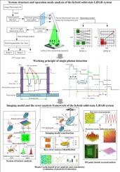
准确的成像模型和误差分析对于评估和校准激光雷达系统至关重要,特别是在高精度3D地形测绘和导航应用中。本研究重点研究了一种混合固态激光雷达系统,该系统集成了32 × 32单光子雪崩二极管(SPAD)阵列、双快速转向镜(FSMs)和基于光栅的分束器,可在动态小行星条件下实现高速、高分辨率成像。这种光学结构的特点是多级光束偏转和基于阵列的检测,这对精确的激光雷达建模和系统误差分析提出了重大挑战。为了解决这些光学复杂性,基于系统的单光子探测特性、扫描模式和多光束分裂,开发了一个成像模型。具体而言,提出了一种基于直方图峰值提取的逐像素距离估计方法,显著提高了高帧率操作下单光子检测的测量精度,从而实现了快速扫描条件下原始测量数据的精确三维坐标重建。此外,建立了基于蒙特卡罗的误差分析框架,以量化11个系统误差源的影响,包括距离偏差、FSM角度误差和内部时序不确定性。还对所有1024个SPAD像素进行了像素级一致性评估,提供了错误传播的详细见解,并揭示了关键的像素级灵敏度。仿真结果表明,弧分级的角度误差导致横向绝对位置偏差均值超过5 cm,而厘米级的距离误差通常导致位置偏差小于2 cm。这些发现与系统的设计规范一致,并突出了角度不确定性对3D重建精度的主要影响。提出的建模和分析框架为静态实验室条件下的早期设计贸易研究、灵敏度分析和校准计划提供了初始的、基于模型的基线。光学模拟演示了扫描模式,静态实验室条件下的地面实验验证了测距/TOF处理和静态几何。此外,实现并验证了基于多位置像元测量的粗标定方法,将测距误差降低到2 cm以下,进一步提高了系统精度,为未来的深空探测任务提供了依据。
本文章由计算机程序翻译,如有差异,请以英文原文为准。

Imaging modeling and error analysis for a hybrid solid-state LiDAR system for the 3D terrain mapping and navigation of small celestial bodies

Imaging modeling and error analysis for a hybrid solid-state LiDAR system for the 3D terrain mapping and navigation of small celestial bodies
Accurate imaging models and error analyses are critical for evaluating and calibrating LiDAR systems, particularly in high-precision 3D terrain mapping and navigation applications. This study focuses on a hybrid solid-state LiDAR system that integrates a 32 × 32 single-photon avalanche diode (SPAD) array, dual fast steering mirrors (FSMs), and a grating-based beam splitter to achieve high-speed, high-resolution imaging under dynamic asteroid conditions. This optical configuration, characterized by multi-stage beam deflection and array-based detection, presents significant challenges for accurate LiDAR modeling and systematic error analysis. To address these optical complexities, an imaging model was developed based on the system’s single-photon detection characteristics, scanning modes and multi-beam splitting. Specifically, a pixel-wise range estimation method was proposed based on histogram peak extraction, significantly enhancing measurement precision for single-photon detection under high frame-rate operation, thus enabling accurate 3D coordinate reconstruction from raw measurements under fast scanning conditions. Additionally, a Monte Carlo-based error analysis framework was established to quantify the impacts of eleven systematic error sources, including range deviations, FSM angular errors, and internal timing uncertainties. A pixel-wise consistency evaluation across all 1024 SPAD pixels was also conducted, providing detailed insights into error propagation and revealing critical pixel-level sensitivities. The simulated results indicate that arcminute-level angular errors lead to mean absolute position deviations exceeding 5  cm in lateral directions, while centimeter-level range errors typically result in position deviations below 2  cm. These findings are consistent with the system’s design specifications and highlight the dominant influence of angular uncertainties on 3D reconstruction accuracy. The proposed modeling and analysis framework provides an initial, model-based baseline for early design trade studies, sensitivity analysis, and calibration planning under static laboratory conditions. Optical simulations illustrate the scanning mode, and ground experiments under static laboratory conditions validate the ranging/TOF processing and static geometry. In addition, a coarse calibration method based on multi-position pixel measurements was implemented and validated, reducing range measurement errors to below 2  cm and further enhancing system accuracy for future deep-space exploration missions.
求助全文
通过发布文献求助,成功后即可免费获取论文全文。 去求助
来源期刊
CiteScore
8.50
自引率
10.00%
发文量
1060
审稿时长
3.4 months
期刊介绍: Optics & Laser Technology aims to provide a vehicle for the publication of a broad range of high quality research and review papers in those fields of scientific and engineering research appertaining to the development and application of the technology of optics and lasers. Papers describing original work in these areas are submitted to rigorous refereeing prior to acceptance for publication. The scope of Optics & Laser Technology encompasses, but is not restricted to, the following areas: •development in all types of lasers •developments in optoelectronic devices and photonics •developments in new photonics and optical concepts •developments in conventional optics, optical instruments and components •techniques of optical metrology, including interferometry and optical fibre sensors •LIDAR and other non-contact optical measurement techniques, including optical methods in heat and fluid flow •applications of lasers to materials processing, optical NDT display (including holography) and optical communication •research and development in the field of laser safety including studies of hazards resulting from the applications of lasers (laser safety, hazards of laser fume) •developments in optical computing and optical information processing •developments in new optical materials •developments in new optical characterization methods and techniques •developments in quantum optics •developments in light assisted micro and nanofabrication methods and techniques •developments in nanophotonics and biophotonics •developments in imaging processing and systems
×
引用
GB/T 7714-2015
复制
MLA
复制
APA
复制
导出至
BibTeX EndNote RefMan NoteFirst NoteExpress
×
提示
您的信息不完整,为了账户安全,请先补充。
现在去补充
×
提示
您因"违规操作"
具体请查看互助需知
我知道了
×
提示
确定
请完成安全验证×
copy
已复制链接
快去分享给好友吧!
我知道了
右上角分享
点击右上角分享
0
联系我们:info@booksci.cn Book学术提供免费学术资源搜索服务,方便国内外学者检索中英文文献。致力于提供最便捷和优质的服务体验。 Copyright © 2023 布克学术 All rights reserved.
京ICP备2023020795号-1
ghs 京公网安备 11010802042870号
Book学术文献互助
Book学术文献互助群
群 号:604180095
Book学术官方微信