基于图聚类神经网络的城市功能区分析

IF 5 2区 社会学 Q1 URBAN STUDIES
Huimin Bai, Xia Zhu, Yuanping Liu, Tiange Zhang, Cui Jia, Jie Cao, Hao Zhang, Xinran Liu
{"title":"基于图聚类神经网络的城市功能区分析","authors":"Huimin Bai,&nbsp;Xia Zhu,&nbsp;Yuanping Liu,&nbsp;Tiange Zhang,&nbsp;Cui Jia,&nbsp;Jie Cao,&nbsp;Hao Zhang,&nbsp;Xinran Liu","doi":"10.1016/j.jum.2025.01.003","DOIUrl":null,"url":null,"abstract":"<div><div>Urban functional areas, as an important fundamental component of urban planning, hold significant importance for optimizing urban layouts, resource allocation, and the rational organization of socio-economic activities. Urban functional area division using traditional methods often has limitations, such as relying on a single data source and using division methods that are mostly based on road network units. To address these issues, this paper considers the impacts of Open Street Map road network data, Point of Interest data, nighttime light data, and land use data on functional area identification and proposes a method based on Graph Clustering Neural Networks to analyze and study urban functional areas. To begin with, the basic datasets are utilized to extract the spatial structure and attribute features of urban functional areas. Then, a transportation network model is constructed by combining the basic characteristics of the road network with socio-economic characteristics. Through the use of Graph Clustering Neural Networks and clustering algorithms, urban functional areas can be identified through clustering through the integration of Graph Neural Networks and clustering algorithms. For functional area analysis, Point of Interest data and land use data are then utilized. Finally, the accuracy of the clustering results is verified by comparison with real images. Beijing was chosen as the study area for this research. The Graph Clustering Neural Network model's urban functional area analysis is highly accurate, allowing for precise identification of the city's spatial distribution characteristics, as demonstrated by the results. The analysis of functional areas offers a better understanding of urban characteristics and distribution patterns, providing more scientific and precise references for urban planning. Additionally, it offers strong support for real-world urban management and decision-making, such as traffic planning, land use optimization, and public resource allocation.</div></div>","PeriodicalId":45131,"journal":{"name":"Journal of Urban Management","volume":"14 3","pages":"Pages 642-656"},"PeriodicalIF":5.0000,"publicationDate":"2025-01-27","publicationTypes":"Journal Article","fieldsOfStudy":null,"isOpenAccess":false,"openAccessPdf":"","citationCount":"0","resultStr":"{\"title\":\"Analysis of urban functional areas based on graph clustering neural networks\",\"authors\":\"Huimin Bai,&nbsp;Xia Zhu,&nbsp;Yuanping Liu,&nbsp;Tiange Zhang,&nbsp;Cui Jia,&nbsp;Jie Cao,&nbsp;Hao Zhang,&nbsp;Xinran Liu\",\"doi\":\"10.1016/j.jum.2025.01.003\",\"DOIUrl\":null,\"url\":null,\"abstract\":\"<div><div>Urban functional areas, as an important fundamental component of urban planning, hold significant importance for optimizing urban layouts, resource allocation, and the rational organization of socio-economic activities. Urban functional area division using traditional methods often has limitations, such as relying on a single data source and using division methods that are mostly based on road network units. To address these issues, this paper considers the impacts of Open Street Map road network data, Point of Interest data, nighttime light data, and land use data on functional area identification and proposes a method based on Graph Clustering Neural Networks to analyze and study urban functional areas. To begin with, the basic datasets are utilized to extract the spatial structure and attribute features of urban functional areas. Then, a transportation network model is constructed by combining the basic characteristics of the road network with socio-economic characteristics. Through the use of Graph Clustering Neural Networks and clustering algorithms, urban functional areas can be identified through clustering through the integration of Graph Neural Networks and clustering algorithms. For functional area analysis, Point of Interest data and land use data are then utilized. Finally, the accuracy of the clustering results is verified by comparison with real images. Beijing was chosen as the study area for this research. The Graph Clustering Neural Network model's urban functional area analysis is highly accurate, allowing for precise identification of the city's spatial distribution characteristics, as demonstrated by the results. The analysis of functional areas offers a better understanding of urban characteristics and distribution patterns, providing more scientific and precise references for urban planning. Additionally, it offers strong support for real-world urban management and decision-making, such as traffic planning, land use optimization, and public resource allocation.</div></div>\",\"PeriodicalId\":45131,\"journal\":{\"name\":\"Journal of Urban Management\",\"volume\":\"14 3\",\"pages\":\"Pages 642-656\"},\"PeriodicalIF\":5.0000,\"publicationDate\":\"2025-01-27\",\"publicationTypes\":\"Journal Article\",\"fieldsOfStudy\":null,\"isOpenAccess\":false,\"openAccessPdf\":\"\",\"citationCount\":\"0\",\"resultStr\":null,\"platform\":\"Semanticscholar\",\"paperid\":null,\"PeriodicalName\":\"Journal of Urban Management\",\"FirstCategoryId\":\"90\",\"ListUrlMain\":\"https://www.sciencedirect.com/science/article/pii/S2226585625000032\",\"RegionNum\":2,\"RegionCategory\":\"社会学\",\"ArticlePicture\":[],\"TitleCN\":null,\"AbstractTextCN\":null,\"PMCID\":null,\"EPubDate\":\"\",\"PubModel\":\"\",\"JCR\":\"Q1\",\"JCRName\":\"URBAN STUDIES\",\"Score\":null,\"Total\":0}","platform":"Semanticscholar","paperid":null,"PeriodicalName":"Journal of Urban Management","FirstCategoryId":"90","ListUrlMain":"https://www.sciencedirect.com/science/article/pii/S2226585625000032","RegionNum":2,"RegionCategory":"社会学","ArticlePicture":[],"TitleCN":null,"AbstractTextCN":null,"PMCID":null,"EPubDate":"","PubModel":"","JCR":"Q1","JCRName":"URBAN STUDIES","Score":null,"Total":0}
引用次数: 0

摘要

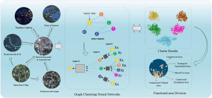
城市功能区作为城市规划的重要基础组成部分,对优化城市布局、优化资源配置、合理组织社会经济活动具有重要意义。传统的城市功能区划分方法往往存在依赖单一数据源、多基于路网单元的划分方法等局限性。针对这些问题,本文考虑了开放街道地图路网数据、兴趣点数据、夜间灯光数据和土地利用数据对功能区识别的影响,提出了一种基于图聚类神经网络的城市功能区分析研究方法。首先,利用基础数据集提取城市功能区的空间结构和属性特征。然后将路网的基本特征与社会经济特征相结合,构建交通网络模型。通过使用图聚类神经网络和聚类算法,通过图神经网络和聚类算法的融合,可以通过聚类来识别城市功能区。对于功能区分析,然后使用兴趣点数据和土地利用数据。最后,通过与真实图像的对比,验证了聚类结果的准确性。本研究选择北京作为研究区域。结果表明,图聚类神经网络模型的城市功能区分析非常准确,可以精确识别城市的空间分布特征。功能区分析有助于更好地了解城市特征和分布格局,为城市规划提供更科学、更精确的参考。此外,它还为现实世界的城市管理和决策提供强有力的支持,如交通规划、土地利用优化和公共资源配置。
本文章由计算机程序翻译,如有差异,请以英文原文为准。

Analysis of urban functional areas based on graph clustering neural networks

Analysis of urban functional areas based on graph clustering neural networks
Urban functional areas, as an important fundamental component of urban planning, hold significant importance for optimizing urban layouts, resource allocation, and the rational organization of socio-economic activities. Urban functional area division using traditional methods often has limitations, such as relying on a single data source and using division methods that are mostly based on road network units. To address these issues, this paper considers the impacts of Open Street Map road network data, Point of Interest data, nighttime light data, and land use data on functional area identification and proposes a method based on Graph Clustering Neural Networks to analyze and study urban functional areas. To begin with, the basic datasets are utilized to extract the spatial structure and attribute features of urban functional areas. Then, a transportation network model is constructed by combining the basic characteristics of the road network with socio-economic characteristics. Through the use of Graph Clustering Neural Networks and clustering algorithms, urban functional areas can be identified through clustering through the integration of Graph Neural Networks and clustering algorithms. For functional area analysis, Point of Interest data and land use data are then utilized. Finally, the accuracy of the clustering results is verified by comparison with real images. Beijing was chosen as the study area for this research. The Graph Clustering Neural Network model's urban functional area analysis is highly accurate, allowing for precise identification of the city's spatial distribution characteristics, as demonstrated by the results. The analysis of functional areas offers a better understanding of urban characteristics and distribution patterns, providing more scientific and precise references for urban planning. Additionally, it offers strong support for real-world urban management and decision-making, such as traffic planning, land use optimization, and public resource allocation.
求助全文
通过发布文献求助,成功后即可免费获取论文全文。 去求助
来源期刊
CiteScore
9.50
自引率
4.90%
发文量
45
审稿时长
65 days
期刊介绍: Journal of Urban Management (JUM) is the Official Journal of Zhejiang University and the Chinese Association of Urban Management, an international, peer-reviewed open access journal covering planning, administering, regulating, and governing urban complexity. JUM has its two-fold aims set to integrate the studies across fields in urban planning and management, as well as to provide a more holistic perspective on problem solving. 1) Explore innovative management skills for taming thorny problems that arise with global urbanization 2) Provide a platform to deal with urban affairs whose solutions must be looked at from an interdisciplinary perspective.
×
引用
GB/T 7714-2015
复制
MLA
复制
APA
复制
导出至
BibTeX EndNote RefMan NoteFirst NoteExpress
×
提示
您的信息不完整,为了账户安全,请先补充。
现在去补充
×
提示
您因"违规操作"
具体请查看互助需知
我知道了
×
提示
确定
请完成安全验证×
copy
已复制链接
快去分享给好友吧!
我知道了
右上角分享
点击右上角分享
0
联系我们:info@booksci.cn Book学术提供免费学术资源搜索服务,方便国内外学者检索中英文文献。致力于提供最便捷和优质的服务体验。 Copyright © 2023 布克学术 All rights reserved.
京ICP备2023020795号-1
ghs 京公网安备 11010802042870号
Book学术文献互助
Book学术文献互助群
群 号:604180095
Book学术官方微信