Francesco Abbatantuono , Giuseppe Lopriore , Anas Tallou , Luca Brillante , Salem Alhajj Ali , Salvatore Camposeo , Gaetano Alessandro Vivaldi
{"title":"通过遥感和近距离传感评估葡萄水分状况的最新进展:综述","authors":"Francesco Abbatantuono , Giuseppe Lopriore , Anas Tallou , Luca Brillante , Salem Alhajj Ali , Salvatore Camposeo , Gaetano Alessandro Vivaldi","doi":"10.1016/j.scienta.2024.113658","DOIUrl":null,"url":null,"abstract":"<div><div>According to modern precision agriculture principles, remote and proximal sensing can be extraordinarily useful tools for sustainable water resource management in viticulture. More than one hundred papers were read and cataloged to outline the most effective methodology (comprised of platforms, cameras, indices, single bands, and statistical methods) for monitoring water status in different wine grape varieties located in different areas. Satellites and airplanes can monitor areas at the regional or larger scale; however, while satellite images can be free, airplane imagery can be more expensive. The use of satellite platforms is particularly promising, especially due to recent technical progress aimed at improving spatial and temporal resolution. In addition, unmanned aerial vehicles (aka drones) equipped with thermal, multispectral, and hyperspectral cameras have provided excellent results. Proximal thermal and spectral cameras (e.g., handheld or installed in tractors) can be an inexpensive alternative but often present similar problems to traditional methods (e.g., time-consuming). The best results were obtained from thermal indices (e.g., Crop Water Stress Index) and the use of machine learning (ML) algorithms on individual bands and indices obtained with hyperspectral or multispectral cameras carried on drone or satellite platforms.</div></div>","PeriodicalId":21679,"journal":{"name":"Scientia Horticulturae","volume":"338 ","pages":"Article 113658"},"PeriodicalIF":3.9000,"publicationDate":"2024-09-27","publicationTypes":"Journal Article","fieldsOfStudy":null,"isOpenAccess":false,"openAccessPdf":"","citationCount":"0","resultStr":"{\"title\":\"Recent progress on grapevine water status assessment through remote and proximal sensing: A review\",\"authors\":\"Francesco Abbatantuono , Giuseppe Lopriore , Anas Tallou , Luca Brillante , Salem Alhajj Ali , Salvatore Camposeo , Gaetano Alessandro Vivaldi\",\"doi\":\"10.1016/j.scienta.2024.113658\",\"DOIUrl\":null,\"url\":null,\"abstract\":\"<div><div>According to modern precision agriculture principles, remote and proximal sensing can be extraordinarily useful tools for sustainable water resource management in viticulture. More than one hundred papers were read and cataloged to outline the most effective methodology (comprised of platforms, cameras, indices, single bands, and statistical methods) for monitoring water status in different wine grape varieties located in different areas. Satellites and airplanes can monitor areas at the regional or larger scale; however, while satellite images can be free, airplane imagery can be more expensive. The use of satellite platforms is particularly promising, especially due to recent technical progress aimed at improving spatial and temporal resolution. In addition, unmanned aerial vehicles (aka drones) equipped with thermal, multispectral, and hyperspectral cameras have provided excellent results. Proximal thermal and spectral cameras (e.g., handheld or installed in tractors) can be an inexpensive alternative but often present similar problems to traditional methods (e.g., time-consuming). The best results were obtained from thermal indices (e.g., Crop Water Stress Index) and the use of machine learning (ML) algorithms on individual bands and indices obtained with hyperspectral or multispectral cameras carried on drone or satellite platforms.</div></div>\",\"PeriodicalId\":21679,\"journal\":{\"name\":\"Scientia Horticulturae\",\"volume\":\"338 \",\"pages\":\"Article 113658\"},\"PeriodicalIF\":3.9000,\"publicationDate\":\"2024-09-27\",\"publicationTypes\":\"Journal Article\",\"fieldsOfStudy\":null,\"isOpenAccess\":false,\"openAccessPdf\":\"\",\"citationCount\":\"0\",\"resultStr\":null,\"platform\":\"Semanticscholar\",\"paperid\":null,\"PeriodicalName\":\"Scientia Horticulturae\",\"FirstCategoryId\":\"97\",\"ListUrlMain\":\"https://www.sciencedirect.com/science/article/pii/S0304423824008112\",\"RegionNum\":2,\"RegionCategory\":\"农林科学\",\"ArticlePicture\":[],\"TitleCN\":null,\"AbstractTextCN\":null,\"PMCID\":null,\"EPubDate\":\"\",\"PubModel\":\"\",\"JCR\":\"Q1\",\"JCRName\":\"HORTICULTURE\",\"Score\":null,\"Total\":0}","platform":"Semanticscholar","paperid":null,"PeriodicalName":"Scientia Horticulturae","FirstCategoryId":"97","ListUrlMain":"https://www.sciencedirect.com/science/article/pii/S0304423824008112","RegionNum":2,"RegionCategory":"农林科学","ArticlePicture":[],"TitleCN":null,"AbstractTextCN":null,"PMCID":null,"EPubDate":"","PubModel":"","JCR":"Q1","JCRName":"HORTICULTURE","Score":null,"Total":0}
Recent progress on grapevine water status assessment through remote and proximal sensing: A review
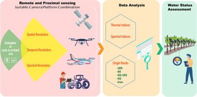
According to modern precision agriculture principles, remote and proximal sensing can be extraordinarily useful tools for sustainable water resource management in viticulture. More than one hundred papers were read and cataloged to outline the most effective methodology (comprised of platforms, cameras, indices, single bands, and statistical methods) for monitoring water status in different wine grape varieties located in different areas. Satellites and airplanes can monitor areas at the regional or larger scale; however, while satellite images can be free, airplane imagery can be more expensive. The use of satellite platforms is particularly promising, especially due to recent technical progress aimed at improving spatial and temporal resolution. In addition, unmanned aerial vehicles (aka drones) equipped with thermal, multispectral, and hyperspectral cameras have provided excellent results. Proximal thermal and spectral cameras (e.g., handheld or installed in tractors) can be an inexpensive alternative but often present similar problems to traditional methods (e.g., time-consuming). The best results were obtained from thermal indices (e.g., Crop Water Stress Index) and the use of machine learning (ML) algorithms on individual bands and indices obtained with hyperspectral or multispectral cameras carried on drone or satellite platforms.
期刊介绍:
Scientia Horticulturae is an international journal publishing research related to horticultural crops. Articles in the journal deal with open or protected production of vegetables, fruits, edible fungi and ornamentals under temperate, subtropical and tropical conditions. Papers in related areas (biochemistry, micropropagation, soil science, plant breeding, plant physiology, phytopathology, etc.) are considered, if they contain information of direct significance to horticulture. Papers on the technical aspects of horticulture (engineering, crop processing, storage, transport etc.) are accepted for publication only if they relate directly to the living product. In the case of plantation crops, those yielding a product that may be used fresh (e.g. tropical vegetables, citrus, bananas, and other fruits) will be considered, while those papers describing the processing of the product (e.g. rubber, tobacco, and quinine) will not. The scope of the journal includes all horticultural crops but does not include speciality crops such as, medicinal crops or forestry crops, such as bamboo. Basic molecular studies without any direct application in horticulture will not be considered for this journal.