Density-Based Road Segmentation Algorithm for Point Cloud Collected by Roadside LiDAR

IF 4.8 1区 工程技术 Q1 ENGINEERING, ELECTRICAL & ELECTRONIC
Yang He, Lisheng Jin, Baicang Guo, Zhen Huo, Huanhuan Wang, Qiukun Jin
{"title":"Density-Based Road Segmentation Algorithm for Point Cloud Collected by Roadside LiDAR","authors":"Yang He,&nbsp;Lisheng Jin,&nbsp;Baicang Guo,&nbsp;Zhen Huo,&nbsp;Huanhuan Wang,&nbsp;Qiukun Jin","doi":"10.1007/s42154-022-00212-1","DOIUrl":null,"url":null,"abstract":"<div><p>This paper proposes a novel density-based real-time segmentation algorithm, to extract ground point cloud in real time from point cloud data collected by roadside LiDAR. The algorithm solves the problems such as the large amount of original point cloud data collected by LiDAR, which leads to heavy computational burden in ground point search. First, point cloud data is filtered by straight-through filtering method and rasterized to improve the real-time performance of the algorithm. Then, the density of the point cloud in horizontal plane is calculated, and the threshold of the density is selected to extract the low-density regional point cloud according to the density statistical histogram and 95% loci. Finally, the low-density regional point cloud is used as the initial ground seeds for iterative optimization of ground parameters, and the ground point cloud is extracted by the fitted ground model to realize road point cloud extraction. The experimental results on 1055 frames of continuous data collected on real scenes show that the average time consumption of the proposed method is 0.11 s, and the average segmentation precision is 92.48%. This shows that the density-based road segmentation algorithm can reduce the time of point cloud traversal in the process of ground parameter fitting and improve the real-time performance of the algorithm while maintaining the accuracy of ground extraction.</p></div>","PeriodicalId":36310,"journal":{"name":"Automotive Innovation","volume":"6 1","pages":"116 - 130"},"PeriodicalIF":4.8000,"publicationDate":"2023-01-25","publicationTypes":"Journal Article","fieldsOfStudy":null,"isOpenAccess":false,"openAccessPdf":"","citationCount":"1","resultStr":null,"platform":"Semanticscholar","paperid":null,"PeriodicalName":"Automotive Innovation","FirstCategoryId":"1087","ListUrlMain":"https://link.springer.com/article/10.1007/s42154-022-00212-1","RegionNum":1,"RegionCategory":"工程技术","ArticlePicture":[],"TitleCN":null,"AbstractTextCN":null,"PMCID":null,"EPubDate":"","PubModel":"","JCR":"Q1","JCRName":"ENGINEERING, ELECTRICAL & ELECTRONIC","Score":null,"Total":0}
引用次数: 1

Abstract

This paper proposes a novel density-based real-time segmentation algorithm, to extract ground point cloud in real time from point cloud data collected by roadside LiDAR. The algorithm solves the problems such as the large amount of original point cloud data collected by LiDAR, which leads to heavy computational burden in ground point search. First, point cloud data is filtered by straight-through filtering method and rasterized to improve the real-time performance of the algorithm. Then, the density of the point cloud in horizontal plane is calculated, and the threshold of the density is selected to extract the low-density regional point cloud according to the density statistical histogram and 95% loci. Finally, the low-density regional point cloud is used as the initial ground seeds for iterative optimization of ground parameters, and the ground point cloud is extracted by the fitted ground model to realize road point cloud extraction. The experimental results on 1055 frames of continuous data collected on real scenes show that the average time consumption of the proposed method is 0.11 s, and the average segmentation precision is 92.48%. This shows that the density-based road segmentation algorithm can reduce the time of point cloud traversal in the process of ground parameter fitting and improve the real-time performance of the algorithm while maintaining the accuracy of ground extraction.
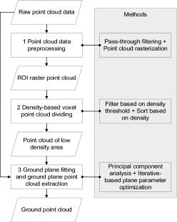

Abstract Image

基于密度的路边激光雷达点云道路分割算法
本文提出了一种新的基于密度的实时分割算法,从路边激光雷达采集的点云数据中实时提取地面点云。该算法解决了激光雷达采集的原始点云数据量大、地面点搜索计算量大等问题。首先,采用直通滤波方法对点云数据进行滤波,并对其进行光栅化处理,以提高算法的实时性。然后,计算点云在水平面上的密度,并根据密度统计直方图和95%的轨迹选择密度阈值来提取低密度区域点云。最后,将低密度区域点云作为地面参数迭代优化的初始地面种子,通过拟合的地面模型提取地面点云,实现道路点云提取。在1055帧真实场景下采集的连续数据上的实验结果表明,该方法的平均耗时为0.11s,平均分割精度为92.48%。这表明基于密度的道路分割算法在保持地面提取精度的同时,可以减少地面参数拟合过程中点云遍历的时间,提高算法的实时性。
本文章由计算机程序翻译,如有差异,请以英文原文为准。
求助全文
约1分钟内获得全文 求助全文
来源期刊
Automotive Innovation
Automotive Innovation Engineering-Automotive Engineering
CiteScore
8.50
自引率
4.90%
发文量
36
期刊介绍: Automotive Innovation is dedicated to the publication of innovative findings in the automotive field as well as other related disciplines, covering the principles, methodologies, theoretical studies, experimental studies, product engineering and engineering application. The main topics include but are not limited to: energy-saving, electrification, intelligent and connected, new energy vehicle, safety and lightweight technologies. The journal presents the latest trend and advances of automotive technology.
×
引用
GB/T 7714-2015
复制
MLA
复制
APA
复制
导出至
BibTeX EndNote RefMan NoteFirst NoteExpress
×
提示
您的信息不完整,为了账户安全,请先补充。
现在去补充
×
提示
您因"违规操作"
具体请查看互助需知
我知道了
×
提示
确定
请完成安全验证×
copy
已复制链接
快去分享给好友吧!
我知道了
右上角分享
点击右上角分享
0
联系我们:info@booksci.cn Book学术提供免费学术资源搜索服务,方便国内外学者检索中英文文献。致力于提供最便捷和优质的服务体验。 Copyright © 2023 布克学术 All rights reserved.
京ICP备2023020795号-1
ghs 京公网安备 11010802042870号
Book学术文献互助
Book学术文献互助群
群 号:481959085
Book学术官方微信