Enhancing urban thermal resilience in multi-mountainous cities through optimized 3D block morphology: a machine learning framework
IF 7.1
2区 工程技术
Q1 CONSTRUCTION & BUILDING TECHNOLOGY
引用次数: 0
Abstract
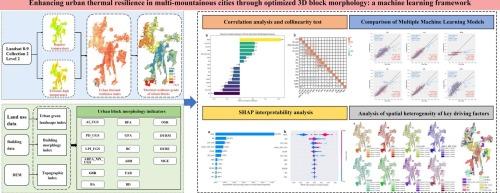
The accelerated global urbanization process has accelerated the significant transformations in land surfaces, leading to the formation of obvious urban overheating phenomena. Maintaining urban thermal resilience can effectively alleviate the impact of extreme high temperatures on communities during heatwaves. This study takes the built-up area of Guiyang City, a typical multi-mountainous city, as the research area, and establishes an evaluation method for urban thermal resilience (UTR) through the difference between conventional temperature and extreme high temperature. Then, based on multi-source data and the characteristics of the study area, we screened the block scale multi-mountainous city morphology index system. The impact of block scale urban form on UTR was quantified from both global and local perspectives using SHAP interpretation model and geographically weighted random forest model. The research results indicate that: (1) The UTR of Guiyang presents a spatial distribution characteristic of low in the middle and high at the edges; The highest values are mainly distributed in the southwest direction near the edge of the city. (2) The urban morphologies are significantly correlated with UTR and has a threshold effect; The average ground elevation (MGE) and building density (BD) are the main driving factors affecting UTR. (3) The UTR of Guiyang exhibits significant spatial clustering, and the impact of urban morphology on UTR also shows spatial heterogeneity. This study provides a scientific foundation for enhancing the thermal environment and promoting sustainable planning in multi-mountainous cities.
通过优化3D块体形态增强多山城市的热弹性:一个机器学习框架
全球城市化进程的加速加速了地表的显著变化,导致城市过热现象明显形成。保持城市热恢复能力可以有效减轻热浪期间极端高温对社区的影响。本研究以典型的多山地城市贵阳市建成区为研究区域,通过常规温度与极端高温之差建立城市热弹性(UTR)评价方法。然后,基于多源数据和研究区特点,筛选块尺度多山城形态指标体系。利用SHAP解译模型和地理加权随机森林模型,从全局和局部角度量化了街区尺度城市形态对UTR的影响。研究结果表明:(1)贵阳市UTR呈中部低、边缘高的空间分布特征;最高值主要分布在靠近城市边缘的西南方向。(2)城市形态与UTR显著相关,存在阈值效应;平均地面高程(MGE)和建筑密度(BD)是影响UTR的主要驱动因素。(3)贵阳市UTR呈现出显著的空间集聚性,城市形态对UTR的影响也呈现出空间异质性。该研究为改善多山城市热环境和促进可持续规划提供了科学依据。
本文章由计算机程序翻译,如有差异,请以英文原文为准。
求助全文
约1分钟内获得全文
求助全文
来源期刊
Energy and Buildings
工程技术-工程:土木
CiteScore
12.70
自引率
11.90%
发文量
863
审稿时长
38 days
期刊介绍:
An international journal devoted to investigations of energy use and efficiency in buildings
Energy and Buildings is an international journal publishing articles with explicit links to energy use in buildings. The aim is to present new research results, and new proven practice aimed at reducing the energy needs of a building and improving indoor environment quality.
 求助内容:
求助内容: 应助结果提醒方式:


