Benjamin D. Goffin , Rishudh Thakur , Sarah Da Conceição Carlos , Duncan Srsic , Caroline Williams , Kenton Ross , Fernando Neira-Román , Carlos Calvo Cortés-Monroy , Venkataraman Lakshmi
{"title":"利用遥感植被指数评估智利中部缺水的Maipo河流域作物系数和实际灌溉需求","authors":"Benjamin D. Goffin , Rishudh Thakur , Sarah Da Conceição Carlos , Duncan Srsic , Caroline Williams , Kenton Ross , Fernando Neira-Román , Carlos Calvo Cortés-Monroy , Venkataraman Lakshmi","doi":"10.1016/j.horiz.2022.100039","DOIUrl":null,"url":null,"abstract":"<div><p>Assessment of irrigation needs for agricultural production has commonly relied on reference crop coefficients derived using limited climatic conditions. This work focused on evaluating actual crop coefficients (Kc) by leveraging available satellite data from Landsat 8 Operational Land Imager (OLI) and Terra Moderate Resolution Imaging Spectroradiometer (MODIS). This method built on the linear relationship and variability between reference Kc from the Food and Agricultural Organization (FAO) and specific site response in Normalized Difference Vegetation Index (NDVI). A regional model was developed for the water-stressed Maipo River Basin of Central Chile during the growing seasons of maize from 2018 to 2022. Throughout model validation, NDVI-based Kc predictions of high quality were found with R-squared scores ranging from 0.77 to 0.97. Relying on Earth observations, this approach provided site-specific Kc values and estimates of actual evapotranspiration without requiring site instruments and/or particular knowledge of farming schedules. Overall, this study has the potential to assist individuals and organizations around the world in improving irrigation management approaches, and advance precision agriculture in the context of water scarcity.</p></div>","PeriodicalId":101199,"journal":{"name":"Sustainable Horizons","volume":"4 ","pages":"Article 100039"},"PeriodicalIF":0.0000,"publicationDate":"2022-10-01","publicationTypes":"Journal Article","fieldsOfStudy":null,"isOpenAccess":false,"openAccessPdf":"https://www.sciencedirect.com/science/article/pii/S2772737822000335/pdfft?md5=a39590d42e70a67aa474c4338eb5fbbf&pid=1-s2.0-S2772737822000335-main.pdf","citationCount":"5","resultStr":"{\"title\":\"Leveraging remotely-sensed vegetation indices to evaluate crop coefficients and actual irrigation requirements in the water-stressed Maipo River Basin of Central Chile\",\"authors\":\"Benjamin D. Goffin , Rishudh Thakur , Sarah Da Conceição Carlos , Duncan Srsic , Caroline Williams , Kenton Ross , Fernando Neira-Román , Carlos Calvo Cortés-Monroy , Venkataraman Lakshmi\",\"doi\":\"10.1016/j.horiz.2022.100039\",\"DOIUrl\":null,\"url\":null,\"abstract\":\"<div><p>Assessment of irrigation needs for agricultural production has commonly relied on reference crop coefficients derived using limited climatic conditions. This work focused on evaluating actual crop coefficients (Kc) by leveraging available satellite data from Landsat 8 Operational Land Imager (OLI) and Terra Moderate Resolution Imaging Spectroradiometer (MODIS). This method built on the linear relationship and variability between reference Kc from the Food and Agricultural Organization (FAO) and specific site response in Normalized Difference Vegetation Index (NDVI). A regional model was developed for the water-stressed Maipo River Basin of Central Chile during the growing seasons of maize from 2018 to 2022. Throughout model validation, NDVI-based Kc predictions of high quality were found with R-squared scores ranging from 0.77 to 0.97. Relying on Earth observations, this approach provided site-specific Kc values and estimates of actual evapotranspiration without requiring site instruments and/or particular knowledge of farming schedules. Overall, this study has the potential to assist individuals and organizations around the world in improving irrigation management approaches, and advance precision agriculture in the context of water scarcity.</p></div>\",\"PeriodicalId\":101199,\"journal\":{\"name\":\"Sustainable Horizons\",\"volume\":\"4 \",\"pages\":\"Article 100039\"},\"PeriodicalIF\":0.0000,\"publicationDate\":\"2022-10-01\",\"publicationTypes\":\"Journal Article\",\"fieldsOfStudy\":null,\"isOpenAccess\":false,\"openAccessPdf\":\"https://www.sciencedirect.com/science/article/pii/S2772737822000335/pdfft?md5=a39590d42e70a67aa474c4338eb5fbbf&pid=1-s2.0-S2772737822000335-main.pdf\",\"citationCount\":\"5\",\"resultStr\":null,\"platform\":\"Semanticscholar\",\"paperid\":null,\"PeriodicalName\":\"Sustainable Horizons\",\"FirstCategoryId\":\"1085\",\"ListUrlMain\":\"https://www.sciencedirect.com/science/article/pii/S2772737822000335\",\"RegionNum\":0,\"RegionCategory\":null,\"ArticlePicture\":[],\"TitleCN\":null,\"AbstractTextCN\":null,\"PMCID\":null,\"EPubDate\":\"\",\"PubModel\":\"\",\"JCR\":\"\",\"JCRName\":\"\",\"Score\":null,\"Total\":0}","platform":"Semanticscholar","paperid":null,"PeriodicalName":"Sustainable Horizons","FirstCategoryId":"1085","ListUrlMain":"https://www.sciencedirect.com/science/article/pii/S2772737822000335","RegionNum":0,"RegionCategory":null,"ArticlePicture":[],"TitleCN":null,"AbstractTextCN":null,"PMCID":null,"EPubDate":"","PubModel":"","JCR":"","JCRName":"","Score":null,"Total":0}
Leveraging remotely-sensed vegetation indices to evaluate crop coefficients and actual irrigation requirements in the water-stressed Maipo River Basin of Central Chile
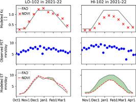
Assessment of irrigation needs for agricultural production has commonly relied on reference crop coefficients derived using limited climatic conditions. This work focused on evaluating actual crop coefficients (Kc) by leveraging available satellite data from Landsat 8 Operational Land Imager (OLI) and Terra Moderate Resolution Imaging Spectroradiometer (MODIS). This method built on the linear relationship and variability between reference Kc from the Food and Agricultural Organization (FAO) and specific site response in Normalized Difference Vegetation Index (NDVI). A regional model was developed for the water-stressed Maipo River Basin of Central Chile during the growing seasons of maize from 2018 to 2022. Throughout model validation, NDVI-based Kc predictions of high quality were found with R-squared scores ranging from 0.77 to 0.97. Relying on Earth observations, this approach provided site-specific Kc values and estimates of actual evapotranspiration without requiring site instruments and/or particular knowledge of farming schedules. Overall, this study has the potential to assist individuals and organizations around the world in improving irrigation management approaches, and advance precision agriculture in the context of water scarcity.

 求助内容:
求助内容: 应助结果提醒方式:


