{"title":"土耳其西地中海盆地气候参数变化的时空模式及其对城市规划的影响","authors":"Oznur Isinkaralar","doi":"10.1007/s11869-023-01416-y","DOIUrl":null,"url":null,"abstract":"<div><h2>Abstract </h2><div><p>In today’s world, where the effects of climate change can be easily monitored, determining the resilience of cities and regions against climate crisis is a fundamental research area in terms of planning approaches. While producing spatial planning decisions, the effects of climate change should be analyzed in terms of time and integrated into the process. While the research reveals the change of spatial bioclimatic comfort zones according to climate change scenarios, it criticizes the position of planning practice within the framework of planning theory and a comprehensive planning approach. The research is carried out on the scale of the Western Mediterranean basin, one of the hot climate regions of Türkiye. The change between 2020 and 2100 is spatially revealed via the climate change scenarios. SSP 245 and SSP 585 are selected for this purpose. Discomfort Index (DI) and Effective Temperature-Taking Wind Velocity (ET<i>v</i>) techniques were used to classify bioclimatic comfort zones. As a result of the research, while the most common (20%) areas are between 16 and 18 °C, the most common temperature range rises to between 25% and 22–24 °C, according to SSP 585. According to DI simulations, 43% of the area is comfortable, and 38% is in cold areas. According to SSP 245, in 2100 forecasts, cold areas decrease to 9%, and hot areas that were not previously present occupy 13%. According to SSP 585, on the other hand, cold areas decrease to 2%, while hot areas reach 41%. With a more optimistic approach, the ET<i>v</i> index changes from a character dominated by slightly cool areas (35%) to mild (43%) and comfortable (26%) areas compared to SSP 585. However, some warm (7%) and quite hot (1%) areas do not exist. The increase in hot areas in the country, including coastal settlements with high tourism potential, is striking. While the research reveals the change of spatial bioclimatic comfort zones according to climate change scenarios, it criticizes the position of planning practice within the framework of planning theory and a comprehensive planning approach. Today, the position of spatial planning decisions based on long-term decisions in the country’s legislation is discussed in the context of the climate crisis.</p></div></div>","PeriodicalId":49109,"journal":{"name":"Air Quality Atmosphere and Health","volume":null,"pages":null},"PeriodicalIF":2.9000,"publicationDate":"2023-08-29","publicationTypes":"Journal Article","fieldsOfStudy":null,"isOpenAccess":false,"openAccessPdf":"","citationCount":"4","resultStr":"{\"title\":\"Spatio-temporal patterns of climate parameter changes in Western Mediterranean basin of Türkiye and implications for urban planning\",\"authors\":\"Oznur Isinkaralar\",\"doi\":\"10.1007/s11869-023-01416-y\",\"DOIUrl\":null,\"url\":null,\"abstract\":\"<div><h2>Abstract </h2><div><p>In today’s world, where the effects of climate change can be easily monitored, determining the resilience of cities and regions against climate crisis is a fundamental research area in terms of planning approaches. While producing spatial planning decisions, the effects of climate change should be analyzed in terms of time and integrated into the process. While the research reveals the change of spatial bioclimatic comfort zones according to climate change scenarios, it criticizes the position of planning practice within the framework of planning theory and a comprehensive planning approach. The research is carried out on the scale of the Western Mediterranean basin, one of the hot climate regions of Türkiye. The change between 2020 and 2100 is spatially revealed via the climate change scenarios. SSP 245 and SSP 585 are selected for this purpose. Discomfort Index (DI) and Effective Temperature-Taking Wind Velocity (ET<i>v</i>) techniques were used to classify bioclimatic comfort zones. As a result of the research, while the most common (20%) areas are between 16 and 18 °C, the most common temperature range rises to between 25% and 22–24 °C, according to SSP 585. According to DI simulations, 43% of the area is comfortable, and 38% is in cold areas. According to SSP 245, in 2100 forecasts, cold areas decrease to 9%, and hot areas that were not previously present occupy 13%. According to SSP 585, on the other hand, cold areas decrease to 2%, while hot areas reach 41%. With a more optimistic approach, the ET<i>v</i> index changes from a character dominated by slightly cool areas (35%) to mild (43%) and comfortable (26%) areas compared to SSP 585. However, some warm (7%) and quite hot (1%) areas do not exist. The increase in hot areas in the country, including coastal settlements with high tourism potential, is striking. While the research reveals the change of spatial bioclimatic comfort zones according to climate change scenarios, it criticizes the position of planning practice within the framework of planning theory and a comprehensive planning approach. Today, the position of spatial planning decisions based on long-term decisions in the country’s legislation is discussed in the context of the climate crisis.</p></div></div>\",\"PeriodicalId\":49109,\"journal\":{\"name\":\"Air Quality Atmosphere and Health\",\"volume\":null,\"pages\":null},\"PeriodicalIF\":2.9000,\"publicationDate\":\"2023-08-29\",\"publicationTypes\":\"Journal Article\",\"fieldsOfStudy\":null,\"isOpenAccess\":false,\"openAccessPdf\":\"\",\"citationCount\":\"4\",\"resultStr\":null,\"platform\":\"Semanticscholar\",\"paperid\":null,\"PeriodicalName\":\"Air Quality Atmosphere and Health\",\"FirstCategoryId\":\"93\",\"ListUrlMain\":\"https://link.springer.com/article/10.1007/s11869-023-01416-y\",\"RegionNum\":4,\"RegionCategory\":\"环境科学与生态学\",\"ArticlePicture\":[],\"TitleCN\":null,\"AbstractTextCN\":null,\"PMCID\":null,\"EPubDate\":\"\",\"PubModel\":\"\",\"JCR\":\"Q3\",\"JCRName\":\"ENVIRONMENTAL SCIENCES\",\"Score\":null,\"Total\":0}","platform":"Semanticscholar","paperid":null,"PeriodicalName":"Air Quality Atmosphere and Health","FirstCategoryId":"93","ListUrlMain":"https://link.springer.com/article/10.1007/s11869-023-01416-y","RegionNum":4,"RegionCategory":"环境科学与生态学","ArticlePicture":[],"TitleCN":null,"AbstractTextCN":null,"PMCID":null,"EPubDate":"","PubModel":"","JCR":"Q3","JCRName":"ENVIRONMENTAL SCIENCES","Score":null,"Total":0}
Spatio-temporal patterns of climate parameter changes in Western Mediterranean basin of Türkiye and implications for urban planning
Abstract
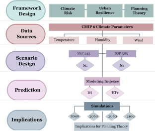
In today’s world, where the effects of climate change can be easily monitored, determining the resilience of cities and regions against climate crisis is a fundamental research area in terms of planning approaches. While producing spatial planning decisions, the effects of climate change should be analyzed in terms of time and integrated into the process. While the research reveals the change of spatial bioclimatic comfort zones according to climate change scenarios, it criticizes the position of planning practice within the framework of planning theory and a comprehensive planning approach. The research is carried out on the scale of the Western Mediterranean basin, one of the hot climate regions of Türkiye. The change between 2020 and 2100 is spatially revealed via the climate change scenarios. SSP 245 and SSP 585 are selected for this purpose. Discomfort Index (DI) and Effective Temperature-Taking Wind Velocity (ETv) techniques were used to classify bioclimatic comfort zones. As a result of the research, while the most common (20%) areas are between 16 and 18 °C, the most common temperature range rises to between 25% and 22–24 °C, according to SSP 585. According to DI simulations, 43% of the area is comfortable, and 38% is in cold areas. According to SSP 245, in 2100 forecasts, cold areas decrease to 9%, and hot areas that were not previously present occupy 13%. According to SSP 585, on the other hand, cold areas decrease to 2%, while hot areas reach 41%. With a more optimistic approach, the ETv index changes from a character dominated by slightly cool areas (35%) to mild (43%) and comfortable (26%) areas compared to SSP 585. However, some warm (7%) and quite hot (1%) areas do not exist. The increase in hot areas in the country, including coastal settlements with high tourism potential, is striking. While the research reveals the change of spatial bioclimatic comfort zones according to climate change scenarios, it criticizes the position of planning practice within the framework of planning theory and a comprehensive planning approach. Today, the position of spatial planning decisions based on long-term decisions in the country’s legislation is discussed in the context of the climate crisis.
期刊介绍:
Air Quality, Atmosphere, and Health is a multidisciplinary journal which, by its very name, illustrates the broad range of work it publishes and which focuses on atmospheric consequences of human activities and their implications for human and ecological health.
It offers research papers, critical literature reviews and commentaries, as well as special issues devoted to topical subjects or themes.
International in scope, the journal presents papers that inform and stimulate a global readership, as the topic addressed are global in their import. Consequently, we do not encourage submission of papers involving local data that relate to local problems. Unless they demonstrate wide applicability, these are better submitted to national or regional journals.
Air Quality, Atmosphere & Health addresses such topics as acid precipitation; airborne particulate matter; air quality monitoring and management; exposure assessment; risk assessment; indoor air quality; atmospheric chemistry; atmospheric modeling and prediction; air pollution climatology; climate change and air quality; air pollution measurement; atmospheric impact assessment; forest-fire emissions; atmospheric science; greenhouse gases; health and ecological effects; clean air technology; regional and global change and satellite measurements.
This journal benefits a diverse audience of researchers, public health officials and policy makers addressing problems that call for solutions based in evidence from atmospheric and exposure assessment scientists, epidemiologists, and risk assessors. Publication in the journal affords the opportunity to reach beyond defined disciplinary niches to this broader readership.
 求助内容:
求助内容: 应助结果提醒方式:


