Hongtao Duan*, Qitao Xiao*, Tianci Qi, Cheng Hu, Mi Zhang, Ming Shen, Zhenghua Hu, Wei Wang, Wei Xiao, Yinguo Qiu, Juhua Luo and Xuhui Lee,
{"title":"大型富营养化湖泊弥漫性甲烷排放的卫星图像量化","authors":"Hongtao Duan*, Qitao Xiao*, Tianci Qi, Cheng Hu, Mi Zhang, Ming Shen, Zhenghua Hu, Wei Wang, Wei Xiao, Yinguo Qiu, Juhua Luo and Xuhui Lee, ","doi":"10.1021/acs.est.3c05631","DOIUrl":null,"url":null,"abstract":"<p >Lakes are major emitters of methane (CH<sub>4</sub>); however, a longstanding challenge with quantifying the magnitude of emissions remains as a result of large spatial and temporal variability. This study was designed to address the issue using satellite remote sensing with the advantages of spatial coverage and temporal resolution. Using Aqua/MODIS imagery (2003–2020) and <i>in situ</i> measured data (2011–2017) in eutrophic Lake Taihu, we compared the performance of eight machine learning models to predict diffusive CH<sub>4</sub> emissions and found that the random forest (RF) model achieved the best fitting accuracy (<i>R</i><sup>2</sup> = 0.65 and mean relative error = 21%). On the basis of input satellite variables (chlorophyll <i>a</i>, water surface temperature, diffuse attenuation coefficient, and photosynthetically active radiation), we assessed how and why they help predict the CH<sub>4</sub> emissions with the RF model. Overall, these variables mechanistically controlled the emissions, leading to the model capturing well the variability of diffusive CH<sub>4</sub> emissions from the lake. Additionally, we found climate warming and associated algal blooms boosted the long-term increase in the emissions via reconstructing historical (2003–2020) daily time series of CH<sub>4</sub> emissions. This study demonstrates the great potential of satellites to map lake CH<sub>4</sub> emissions by providing spatiotemporal continuous data, with new and timely insights into accurately understanding the magnitude of aquatic greenhouse gas emissions.</p>","PeriodicalId":36,"journal":{"name":"环境科学与技术","volume":"57 36","pages":"13520–13529"},"PeriodicalIF":10.8000,"publicationDate":"2023-08-31","publicationTypes":"Journal Article","fieldsOfStudy":null,"isOpenAccess":false,"openAccessPdf":"","citationCount":"0","resultStr":"{\"title\":\"Quantification of Diffusive Methane Emissions from a Large Eutrophic Lake with Satellite Imagery\",\"authors\":\"Hongtao Duan*, Qitao Xiao*, Tianci Qi, Cheng Hu, Mi Zhang, Ming Shen, Zhenghua Hu, Wei Wang, Wei Xiao, Yinguo Qiu, Juhua Luo and Xuhui Lee, \",\"doi\":\"10.1021/acs.est.3c05631\",\"DOIUrl\":null,\"url\":null,\"abstract\":\"<p >Lakes are major emitters of methane (CH<sub>4</sub>); however, a longstanding challenge with quantifying the magnitude of emissions remains as a result of large spatial and temporal variability. This study was designed to address the issue using satellite remote sensing with the advantages of spatial coverage and temporal resolution. Using Aqua/MODIS imagery (2003–2020) and <i>in situ</i> measured data (2011–2017) in eutrophic Lake Taihu, we compared the performance of eight machine learning models to predict diffusive CH<sub>4</sub> emissions and found that the random forest (RF) model achieved the best fitting accuracy (<i>R</i><sup>2</sup> = 0.65 and mean relative error = 21%). On the basis of input satellite variables (chlorophyll <i>a</i>, water surface temperature, diffuse attenuation coefficient, and photosynthetically active radiation), we assessed how and why they help predict the CH<sub>4</sub> emissions with the RF model. Overall, these variables mechanistically controlled the emissions, leading to the model capturing well the variability of diffusive CH<sub>4</sub> emissions from the lake. Additionally, we found climate warming and associated algal blooms boosted the long-term increase in the emissions via reconstructing historical (2003–2020) daily time series of CH<sub>4</sub> emissions. This study demonstrates the great potential of satellites to map lake CH<sub>4</sub> emissions by providing spatiotemporal continuous data, with new and timely insights into accurately understanding the magnitude of aquatic greenhouse gas emissions.</p>\",\"PeriodicalId\":36,\"journal\":{\"name\":\"环境科学与技术\",\"volume\":\"57 36\",\"pages\":\"13520–13529\"},\"PeriodicalIF\":10.8000,\"publicationDate\":\"2023-08-31\",\"publicationTypes\":\"Journal Article\",\"fieldsOfStudy\":null,\"isOpenAccess\":false,\"openAccessPdf\":\"\",\"citationCount\":\"0\",\"resultStr\":null,\"platform\":\"Semanticscholar\",\"paperid\":null,\"PeriodicalName\":\"环境科学与技术\",\"FirstCategoryId\":\"1\",\"ListUrlMain\":\"https://pubs.acs.org/doi/10.1021/acs.est.3c05631\",\"RegionNum\":1,\"RegionCategory\":\"环境科学与生态学\",\"ArticlePicture\":[],\"TitleCN\":null,\"AbstractTextCN\":null,\"PMCID\":null,\"EPubDate\":\"\",\"PubModel\":\"\",\"JCR\":\"Q1\",\"JCRName\":\"ENGINEERING, ENVIRONMENTAL\",\"Score\":null,\"Total\":0}","platform":"Semanticscholar","paperid":null,"PeriodicalName":"环境科学与技术","FirstCategoryId":"1","ListUrlMain":"https://pubs.acs.org/doi/10.1021/acs.est.3c05631","RegionNum":1,"RegionCategory":"环境科学与生态学","ArticlePicture":[],"TitleCN":null,"AbstractTextCN":null,"PMCID":null,"EPubDate":"","PubModel":"","JCR":"Q1","JCRName":"ENGINEERING, ENVIRONMENTAL","Score":null,"Total":0}
Quantification of Diffusive Methane Emissions from a Large Eutrophic Lake with Satellite Imagery
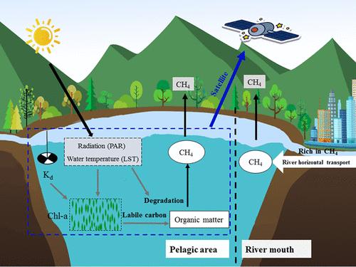
Lakes are major emitters of methane (CH4); however, a longstanding challenge with quantifying the magnitude of emissions remains as a result of large spatial and temporal variability. This study was designed to address the issue using satellite remote sensing with the advantages of spatial coverage and temporal resolution. Using Aqua/MODIS imagery (2003–2020) and in situ measured data (2011–2017) in eutrophic Lake Taihu, we compared the performance of eight machine learning models to predict diffusive CH4 emissions and found that the random forest (RF) model achieved the best fitting accuracy (R2 = 0.65 and mean relative error = 21%). On the basis of input satellite variables (chlorophyll a, water surface temperature, diffuse attenuation coefficient, and photosynthetically active radiation), we assessed how and why they help predict the CH4 emissions with the RF model. Overall, these variables mechanistically controlled the emissions, leading to the model capturing well the variability of diffusive CH4 emissions from the lake. Additionally, we found climate warming and associated algal blooms boosted the long-term increase in the emissions via reconstructing historical (2003–2020) daily time series of CH4 emissions. This study demonstrates the great potential of satellites to map lake CH4 emissions by providing spatiotemporal continuous data, with new and timely insights into accurately understanding the magnitude of aquatic greenhouse gas emissions.
期刊介绍:
Environmental Science & Technology (ES&T) is a co-sponsored academic and technical magazine by the Hubei Provincial Environmental Protection Bureau and the Hubei Provincial Academy of Environmental Sciences.
Environmental Science & Technology (ES&T) holds the status of Chinese core journals, scientific papers source journals of China, Chinese Science Citation Database source journals, and Chinese Academic Journal Comprehensive Evaluation Database source journals. This publication focuses on the academic field of environmental protection, featuring articles related to environmental protection and technical advancements.
 求助内容:
求助内容: 应助结果提醒方式:


