Jennifer Danneck, Darrel Chin Fung Tiang, Khanh Ngo Duc, Badrul Azhar, Ruzana Sanusi, Ahimsa Campos-Arceiz, Alex M. Lechner
{"title":"通过连接绿地网络来保护城市热带生物多样性","authors":"Jennifer Danneck, Darrel Chin Fung Tiang, Khanh Ngo Duc, Badrul Azhar, Ruzana Sanusi, Ahimsa Campos-Arceiz, Alex M. Lechner","doi":"10.1002/inc3.21","DOIUrl":null,"url":null,"abstract":"<p>Tropical Southeast Asia is a hotspot for global biodiversity, and also a hotspot for rapidly expanding urbanisation. There is a need to identify, protect, restore and connect remaining green spaces in the urban matrix before this opportunity is lost to urban development. The objective of this study is to characterise ecological connectivity for mammals and identify important patches and linkages for connecting urban green spaces for Greater Kuala Lumpur (KL), Malaysia. We first map land cover across the region using a linear mixture model with preprocessed multidate cloud-free mosaics derived from Sentinel 2 remote sensing data in Google Earth Engine. We then model connectivity using the land cover maps, expert-based parameterisation of Euclidian distance and graph-based connectivity models for a range of dispersal guilds representing small and medium terrestrial and arboreal mammals. Our analysis showed large differences in the effects of fragmentation within Greater KL on the different dispersal groups, with some groups perceiving the landscape as disconnected. However, our analysis identified a network of green patches and pathways which potentially could support connectivity in the urban landscape. Our results demonstrate the potential for Southeast Asian megacities to support biodiversity in the urban context, and the potential for a different kind of urban development, which supports biodiversity in its urban fabric.</p>","PeriodicalId":100680,"journal":{"name":"Integrative Conservation","volume":"2 2","pages":"80-94"},"PeriodicalIF":0.0000,"publicationDate":"2023-06-30","publicationTypes":"Journal Article","fieldsOfStudy":null,"isOpenAccess":false,"openAccessPdf":"https://onlinelibrary.wiley.com/doi/epdf/10.1002/inc3.21","citationCount":"0","resultStr":"{\"title\":\"Conserving urban tropical biodiversity by connecting networks of green patches\\n 连通绿地斑块, 保护热带城市生物多样性\\n Memulihara biodiversiti tropika bandar dengan menghubungkan rangkaian tompok kawasan hijau\",\"authors\":\"Jennifer Danneck, Darrel Chin Fung Tiang, Khanh Ngo Duc, Badrul Azhar, Ruzana Sanusi, Ahimsa Campos-Arceiz, Alex M. Lechner\",\"doi\":\"10.1002/inc3.21\",\"DOIUrl\":null,\"url\":null,\"abstract\":\"<p>Tropical Southeast Asia is a hotspot for global biodiversity, and also a hotspot for rapidly expanding urbanisation. There is a need to identify, protect, restore and connect remaining green spaces in the urban matrix before this opportunity is lost to urban development. The objective of this study is to characterise ecological connectivity for mammals and identify important patches and linkages for connecting urban green spaces for Greater Kuala Lumpur (KL), Malaysia. We first map land cover across the region using a linear mixture model with preprocessed multidate cloud-free mosaics derived from Sentinel 2 remote sensing data in Google Earth Engine. We then model connectivity using the land cover maps, expert-based parameterisation of Euclidian distance and graph-based connectivity models for a range of dispersal guilds representing small and medium terrestrial and arboreal mammals. Our analysis showed large differences in the effects of fragmentation within Greater KL on the different dispersal groups, with some groups perceiving the landscape as disconnected. However, our analysis identified a network of green patches and pathways which potentially could support connectivity in the urban landscape. Our results demonstrate the potential for Southeast Asian megacities to support biodiversity in the urban context, and the potential for a different kind of urban development, which supports biodiversity in its urban fabric.</p>\",\"PeriodicalId\":100680,\"journal\":{\"name\":\"Integrative Conservation\",\"volume\":\"2 2\",\"pages\":\"80-94\"},\"PeriodicalIF\":0.0000,\"publicationDate\":\"2023-06-30\",\"publicationTypes\":\"Journal Article\",\"fieldsOfStudy\":null,\"isOpenAccess\":false,\"openAccessPdf\":\"https://onlinelibrary.wiley.com/doi/epdf/10.1002/inc3.21\",\"citationCount\":\"0\",\"resultStr\":null,\"platform\":\"Semanticscholar\",\"paperid\":null,\"PeriodicalName\":\"Integrative Conservation\",\"FirstCategoryId\":\"1085\",\"ListUrlMain\":\"https://onlinelibrary.wiley.com/doi/10.1002/inc3.21\",\"RegionNum\":0,\"RegionCategory\":null,\"ArticlePicture\":[],\"TitleCN\":null,\"AbstractTextCN\":null,\"PMCID\":null,\"EPubDate\":\"\",\"PubModel\":\"\",\"JCR\":\"\",\"JCRName\":\"\",\"Score\":null,\"Total\":0}","platform":"Semanticscholar","paperid":null,"PeriodicalName":"Integrative Conservation","FirstCategoryId":"1085","ListUrlMain":"https://onlinelibrary.wiley.com/doi/10.1002/inc3.21","RegionNum":0,"RegionCategory":null,"ArticlePicture":[],"TitleCN":null,"AbstractTextCN":null,"PMCID":null,"EPubDate":"","PubModel":"","JCR":"","JCRName":"","Score":null,"Total":0}
Conserving urban tropical biodiversity by connecting networks of green patches
连通绿地斑块, 保护热带城市生物多样性
Memulihara biodiversiti tropika bandar dengan menghubungkan rangkaian tompok kawasan hijau
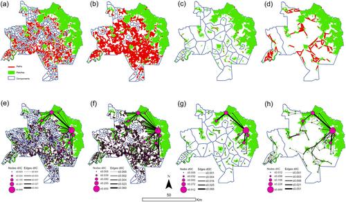
Tropical Southeast Asia is a hotspot for global biodiversity, and also a hotspot for rapidly expanding urbanisation. There is a need to identify, protect, restore and connect remaining green spaces in the urban matrix before this opportunity is lost to urban development. The objective of this study is to characterise ecological connectivity for mammals and identify important patches and linkages for connecting urban green spaces for Greater Kuala Lumpur (KL), Malaysia. We first map land cover across the region using a linear mixture model with preprocessed multidate cloud-free mosaics derived from Sentinel 2 remote sensing data in Google Earth Engine. We then model connectivity using the land cover maps, expert-based parameterisation of Euclidian distance and graph-based connectivity models for a range of dispersal guilds representing small and medium terrestrial and arboreal mammals. Our analysis showed large differences in the effects of fragmentation within Greater KL on the different dispersal groups, with some groups perceiving the landscape as disconnected. However, our analysis identified a network of green patches and pathways which potentially could support connectivity in the urban landscape. Our results demonstrate the potential for Southeast Asian megacities to support biodiversity in the urban context, and the potential for a different kind of urban development, which supports biodiversity in its urban fabric.

 求助内容:
求助内容: 应助结果提醒方式:


