Sharun Beream Nasir, Michelle Li Ern Ang, Tapan Kumar Nath, John Owen, Angela Tritto, Alex M. Lechner
{"title":"Modeling past and future land use changes from mining, agriculture, industry, and biodiversity in a rapidly developing Southeast Asian region","authors":"Sharun Beream Nasir, Michelle Li Ern Ang, Tapan Kumar Nath, John Owen, Angela Tritto, Alex M. Lechner","doi":"10.1002/inc3.17","DOIUrl":null,"url":null,"abstract":"<p>Rapidly developing regions in Southeast Asia, such as Kuantan, Malaysia, require robust spatial analysis to understand changing landscape patterns and their socioenvironmental impacts to guide sustainable development and conservation planning. This study aims to characterise and evaluate the historic and future projections of land-use and land-cover (LULC) change patterns to understand the dynamics of the regional development process and identify potential future land-use conflicts. We first map coarse-scale land-cover classes using Landsat 5 TM and Landsat 8 OLI data and a Random Forest classifier in the Google Earth Engine platform, and then use auxiliary reference data to manually construct fine-scale LULC for 3 years: 2010, 2015 and 2020. Subsequently, we modelled future LULC change patterns in 2030 using Land Change Modeller, which applies a multilayer perceptron neural network and Markov chain analysis. The study showed that the region's land cover in the last 10 years has been largely altered by human intervention, driven by an increase in oil palm plantations, followed by mining, residential and industrial site expansion, with a consequent decline in forest and vegetation cover. The 2030 land-use projections revealed a continuation of these land-use development patterns. The modelling showed that industry, mining and residential LULC are clustered and growing closer in proximity while expanding extensively, likely causing future land-use conflict and lead to further environmental degradation. Furthermore, our analysis showed extensive decline in forest cover within reserves. Our modelling demonstrated that natural resource management needs to take an integrated approach as the drivers of land-use changes are complex, competing and dynamic.</p>","PeriodicalId":100680,"journal":{"name":"Integrative Conservation","volume":"2 1","pages":"43-61"},"PeriodicalIF":0.0000,"publicationDate":"2023-03-23","publicationTypes":"Journal Article","fieldsOfStudy":null,"isOpenAccess":false,"openAccessPdf":"https://onlinelibrary.wiley.com/doi/epdf/10.1002/inc3.17","citationCount":"0","resultStr":"{\"title\":\"Modelling past and future land-use changes from mining, agriculture, industry and biodiversity in a rapidly developing Southeast Asian region\\n 采矿、农业、工业和生物多样性保护影响下东南亚快速发展区域过去和未来土地利用变化模拟\",\"authors\":\"Sharun Beream Nasir, Michelle Li Ern Ang, Tapan Kumar Nath, John Owen, Angela Tritto, Alex M. Lechner\",\"doi\":\"10.1002/inc3.17\",\"DOIUrl\":null,\"url\":null,\"abstract\":\"<p>Rapidly developing regions in Southeast Asia, such as Kuantan, Malaysia, require robust spatial analysis to understand changing landscape patterns and their socioenvironmental impacts to guide sustainable development and conservation planning. This study aims to characterise and evaluate the historic and future projections of land-use and land-cover (LULC) change patterns to understand the dynamics of the regional development process and identify potential future land-use conflicts. We first map coarse-scale land-cover classes using Landsat 5 TM and Landsat 8 OLI data and a Random Forest classifier in the Google Earth Engine platform, and then use auxiliary reference data to manually construct fine-scale LULC for 3 years: 2010, 2015 and 2020. Subsequently, we modelled future LULC change patterns in 2030 using Land Change Modeller, which applies a multilayer perceptron neural network and Markov chain analysis. The study showed that the region's land cover in the last 10 years has been largely altered by human intervention, driven by an increase in oil palm plantations, followed by mining, residential and industrial site expansion, with a consequent decline in forest and vegetation cover. The 2030 land-use projections revealed a continuation of these land-use development patterns. The modelling showed that industry, mining and residential LULC are clustered and growing closer in proximity while expanding extensively, likely causing future land-use conflict and lead to further environmental degradation. Furthermore, our analysis showed extensive decline in forest cover within reserves. Our modelling demonstrated that natural resource management needs to take an integrated approach as the drivers of land-use changes are complex, competing and dynamic.</p>\",\"PeriodicalId\":100680,\"journal\":{\"name\":\"Integrative Conservation\",\"volume\":\"2 1\",\"pages\":\"43-61\"},\"PeriodicalIF\":0.0000,\"publicationDate\":\"2023-03-23\",\"publicationTypes\":\"Journal Article\",\"fieldsOfStudy\":null,\"isOpenAccess\":false,\"openAccessPdf\":\"https://onlinelibrary.wiley.com/doi/epdf/10.1002/inc3.17\",\"citationCount\":\"0\",\"resultStr\":null,\"platform\":\"Semanticscholar\",\"paperid\":null,\"PeriodicalName\":\"Integrative Conservation\",\"FirstCategoryId\":\"1085\",\"ListUrlMain\":\"https://onlinelibrary.wiley.com/doi/10.1002/inc3.17\",\"RegionNum\":0,\"RegionCategory\":null,\"ArticlePicture\":[],\"TitleCN\":null,\"AbstractTextCN\":null,\"PMCID\":null,\"EPubDate\":\"\",\"PubModel\":\"\",\"JCR\":\"\",\"JCRName\":\"\",\"Score\":null,\"Total\":0}","platform":"Semanticscholar","paperid":null,"PeriodicalName":"Integrative Conservation","FirstCategoryId":"1085","ListUrlMain":"https://onlinelibrary.wiley.com/doi/10.1002/inc3.17","RegionNum":0,"RegionCategory":null,"ArticlePicture":[],"TitleCN":null,"AbstractTextCN":null,"PMCID":null,"EPubDate":"","PubModel":"","JCR":"","JCRName":"","Score":null,"Total":0}
Modelling past and future land-use changes from mining, agriculture, industry and biodiversity in a rapidly developing Southeast Asian region
采矿、农业、工业和生物多样性保护影响下东南亚快速发展区域过去和未来土地利用变化模拟
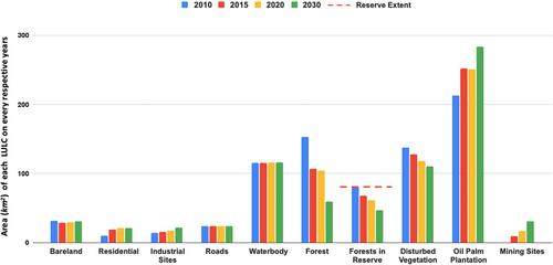
Rapidly developing regions in Southeast Asia, such as Kuantan, Malaysia, require robust spatial analysis to understand changing landscape patterns and their socioenvironmental impacts to guide sustainable development and conservation planning. This study aims to characterise and evaluate the historic and future projections of land-use and land-cover (LULC) change patterns to understand the dynamics of the regional development process and identify potential future land-use conflicts. We first map coarse-scale land-cover classes using Landsat 5 TM and Landsat 8 OLI data and a Random Forest classifier in the Google Earth Engine platform, and then use auxiliary reference data to manually construct fine-scale LULC for 3 years: 2010, 2015 and 2020. Subsequently, we modelled future LULC change patterns in 2030 using Land Change Modeller, which applies a multilayer perceptron neural network and Markov chain analysis. The study showed that the region's land cover in the last 10 years has been largely altered by human intervention, driven by an increase in oil palm plantations, followed by mining, residential and industrial site expansion, with a consequent decline in forest and vegetation cover. The 2030 land-use projections revealed a continuation of these land-use development patterns. The modelling showed that industry, mining and residential LULC are clustered and growing closer in proximity while expanding extensively, likely causing future land-use conflict and lead to further environmental degradation. Furthermore, our analysis showed extensive decline in forest cover within reserves. Our modelling demonstrated that natural resource management needs to take an integrated approach as the drivers of land-use changes are complex, competing and dynamic.

 求助内容:
求助内容: 应助结果提醒方式:


