Matthew Dalton, Neal Spencer, Mark G. Macklin, Jamie C. Woodward, Philippa Ryan
{"title":"尼罗河流域3000年的河道工程","authors":"Matthew Dalton, Neal Spencer, Mark G. Macklin, Jamie C. Woodward, Philippa Ryan","doi":"10.1002/gea.21965","DOIUrl":null,"url":null,"abstract":"<p>Across a 1000-km stretch of the River Nile, from the 1st Cataract in southern Egypt to the 4th Cataract in Sudan, many hundreds of drystone walls are located within active channels, on seasonally inundated floodplains or in now-dry Holocene palaeochannel belts. These walls (or river groynes) functioned as flood and flow control structures and are of a type now commonly in use worldwide. In the Nile Valley, the structures have been subject only to localised investigations, and none have been radiometrically dated. Some were built within living memory to trap nutrient-rich Nile silts for agriculture, a practice already recorded in the early 19th century C.E. However, others situated within ancient palaeochannel belts indicate construction over much longer time frames. In this paper, we map the distribution of these river groynes using remote sensing and drone survey. We then establish their probable functions and a provisional chronology using ethnoarchaeological investigation and the ground survey, excavation and radiometric dating of the structures in northern Sudan, focusing on the Holocene riverine landscape surrounding the pharaonic settlement of Amara West (c. 1300–1000 B.C.E.). Finally, we consider the historical and economic implications of this form of hydraulic engineering in the Nile Valley over the past three millennia.</p>","PeriodicalId":55117,"journal":{"name":"Geoarchaeology-An International Journal","volume":"38 5","pages":"565-587"},"PeriodicalIF":1.4000,"publicationDate":"2023-05-27","publicationTypes":"Journal Article","fieldsOfStudy":null,"isOpenAccess":false,"openAccessPdf":"https://onlinelibrary.wiley.com/doi/epdf/10.1002/gea.21965","citationCount":"0","resultStr":"{\"title\":\"Three thousand years of river channel engineering in the Nile Valley\",\"authors\":\"Matthew Dalton, Neal Spencer, Mark G. Macklin, Jamie C. Woodward, Philippa Ryan\",\"doi\":\"10.1002/gea.21965\",\"DOIUrl\":null,\"url\":null,\"abstract\":\"<p>Across a 1000-km stretch of the River Nile, from the 1st Cataract in southern Egypt to the 4th Cataract in Sudan, many hundreds of drystone walls are located within active channels, on seasonally inundated floodplains or in now-dry Holocene palaeochannel belts. These walls (or river groynes) functioned as flood and flow control structures and are of a type now commonly in use worldwide. In the Nile Valley, the structures have been subject only to localised investigations, and none have been radiometrically dated. Some were built within living memory to trap nutrient-rich Nile silts for agriculture, a practice already recorded in the early 19th century C.E. However, others situated within ancient palaeochannel belts indicate construction over much longer time frames. In this paper, we map the distribution of these river groynes using remote sensing and drone survey. We then establish their probable functions and a provisional chronology using ethnoarchaeological investigation and the ground survey, excavation and radiometric dating of the structures in northern Sudan, focusing on the Holocene riverine landscape surrounding the pharaonic settlement of Amara West (c. 1300–1000 B.C.E.). Finally, we consider the historical and economic implications of this form of hydraulic engineering in the Nile Valley over the past three millennia.</p>\",\"PeriodicalId\":55117,\"journal\":{\"name\":\"Geoarchaeology-An International Journal\",\"volume\":\"38 5\",\"pages\":\"565-587\"},\"PeriodicalIF\":1.4000,\"publicationDate\":\"2023-05-27\",\"publicationTypes\":\"Journal Article\",\"fieldsOfStudy\":null,\"isOpenAccess\":false,\"openAccessPdf\":\"https://onlinelibrary.wiley.com/doi/epdf/10.1002/gea.21965\",\"citationCount\":\"0\",\"resultStr\":null,\"platform\":\"Semanticscholar\",\"paperid\":null,\"PeriodicalName\":\"Geoarchaeology-An International Journal\",\"FirstCategoryId\":\"89\",\"ListUrlMain\":\"https://onlinelibrary.wiley.com/doi/10.1002/gea.21965\",\"RegionNum\":3,\"RegionCategory\":\"地球科学\",\"ArticlePicture\":[],\"TitleCN\":null,\"AbstractTextCN\":null,\"PMCID\":null,\"EPubDate\":\"\",\"PubModel\":\"\",\"JCR\":\"0\",\"JCRName\":\"ARCHAEOLOGY\",\"Score\":null,\"Total\":0}","platform":"Semanticscholar","paperid":null,"PeriodicalName":"Geoarchaeology-An International Journal","FirstCategoryId":"89","ListUrlMain":"https://onlinelibrary.wiley.com/doi/10.1002/gea.21965","RegionNum":3,"RegionCategory":"地球科学","ArticlePicture":[],"TitleCN":null,"AbstractTextCN":null,"PMCID":null,"EPubDate":"","PubModel":"","JCR":"0","JCRName":"ARCHAEOLOGY","Score":null,"Total":0}
Three thousand years of river channel engineering in the Nile Valley
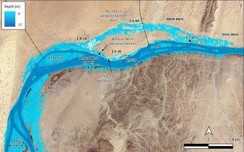
Across a 1000-km stretch of the River Nile, from the 1st Cataract in southern Egypt to the 4th Cataract in Sudan, many hundreds of drystone walls are located within active channels, on seasonally inundated floodplains or in now-dry Holocene palaeochannel belts. These walls (or river groynes) functioned as flood and flow control structures and are of a type now commonly in use worldwide. In the Nile Valley, the structures have been subject only to localised investigations, and none have been radiometrically dated. Some were built within living memory to trap nutrient-rich Nile silts for agriculture, a practice already recorded in the early 19th century C.E. However, others situated within ancient palaeochannel belts indicate construction over much longer time frames. In this paper, we map the distribution of these river groynes using remote sensing and drone survey. We then establish their probable functions and a provisional chronology using ethnoarchaeological investigation and the ground survey, excavation and radiometric dating of the structures in northern Sudan, focusing on the Holocene riverine landscape surrounding the pharaonic settlement of Amara West (c. 1300–1000 B.C.E.). Finally, we consider the historical and economic implications of this form of hydraulic engineering in the Nile Valley over the past three millennia.
期刊介绍:
Geoarchaeology is an interdisciplinary journal published six times per year (in January, March, May, July, September and November). It presents the results of original research at the methodological and theoretical interface between archaeology and the geosciences and includes within its scope: interdisciplinary work focusing on understanding archaeological sites, their environmental context, and particularly site formation processes and how the analysis of sedimentary records can enhance our understanding of human activity in Quaternary environments. Manuscripts should examine the interrelationship between archaeology and the various disciplines within Quaternary science and the Earth Sciences more generally, including, for example: geology, geography, geomorphology, pedology, climatology, oceanography, geochemistry, geochronology, and geophysics. We also welcome papers that deal with the biological record of past human activity through the analysis of faunal and botanical remains and palaeoecological reconstructions that shed light on past human-environment interactions. The journal also welcomes manuscripts concerning the examination and geological context of human fossil remains as well as papers that employ analytical techniques to advance understanding of the composition and origin or material culture such as, for example, ceramics, metals, lithics, building stones, plasters, and cements. Such composition and provenance studies should be strongly grounded in their geological context through, for example, the systematic analysis of potential source materials.
 求助内容:
求助内容: 应助结果提醒方式:


