{"title":"基于gis的摩洛哥沿海Ghiss-Nekor含水层海水入侵的时空演变","authors":"Abdelhak Bourjila , Fouad Dimane , Mohammad Ghalit , Morad Taher , Salim Kamari , Yahya El Hammoudani , Iliass Achoukhi , Khadija Haboubi","doi":"10.1016/j.watcyc.2023.05.002","DOIUrl":null,"url":null,"abstract":"<div><p>The impact of seawater intrusion on coastal aquifers is a major concern in managing groundwater resources. The unconfined coastal aquifer of Ghiss-Nekor, located in a semi-arid area, is particularly vulnerable to seawater intrusion (SWI) because of excessive groundwater pumping and climate change impacts. Therefore, the main goal of the present work is to track the spatiotemporal evolution of SWI in the Ghiss-Nekor aquifer by analyzing data from the years 2015 and 2022 using appropriate geochemical approaches. Accordingly, a range of geochemical techniques were employed, including the Piper diagram, Chadha's diagram, Gibbs diagram, Stiff diagram, major ions variation maps, Hydrochemical Facies Evolution Diagrams (HFE-D), and seawater fraction (f<sub>sea</sub>). As a result, Gibbs diagram clearly indicates the contribution of seawater to the salinization of the Ghiss-Nekor aquifer. Further information is provided by the Piper, Chadha, and Stiff diagrams, which reveal that 29%–38% of the wells studied display Na–Cl water type, a characteristic feature of seawater facies. Additionally, statistical analysis shows a significant increase in salinity levels between 2015 and 2022. Furthermore, the spatiotemporal analysis using the differential mapping technique (DMT) confirmed the increase of salinity, particularly near the shoreline. Additionally, the HFE-D showed that the region impacted by SWI increased from 14% to 20% between 2015 and 2022, and the maximum f<sub>sea</sub> value rose from 14.84% to 25.77% over the same time frame. Our findings reinforce the assumption that SWI is worsening over time in the Ghiss-Nekor aquifer. In summary, the techniques used in this study were effective in tracking the spatiotemporal evolution of SWI in the aquifer and in quantifying it. The results of this study can inform the development of effective strategies for managing SWI in coastal aquifers.</p></div>","PeriodicalId":34143,"journal":{"name":"Water Cycle","volume":"4 ","pages":"Pages 104-119"},"PeriodicalIF":8.7000,"publicationDate":"2023-01-01","publicationTypes":"Journal Article","fieldsOfStudy":null,"isOpenAccess":false,"openAccessPdf":"","citationCount":"1","resultStr":"{\"title\":\"Mapping the spatiotemporal evolution of seawater intrusion in the Moroccan coastal aquifer of Ghiss-Nekor using GIS-based modeling\",\"authors\":\"Abdelhak Bourjila , Fouad Dimane , Mohammad Ghalit , Morad Taher , Salim Kamari , Yahya El Hammoudani , Iliass Achoukhi , Khadija Haboubi\",\"doi\":\"10.1016/j.watcyc.2023.05.002\",\"DOIUrl\":null,\"url\":null,\"abstract\":\"<div><p>The impact of seawater intrusion on coastal aquifers is a major concern in managing groundwater resources. The unconfined coastal aquifer of Ghiss-Nekor, located in a semi-arid area, is particularly vulnerable to seawater intrusion (SWI) because of excessive groundwater pumping and climate change impacts. Therefore, the main goal of the present work is to track the spatiotemporal evolution of SWI in the Ghiss-Nekor aquifer by analyzing data from the years 2015 and 2022 using appropriate geochemical approaches. Accordingly, a range of geochemical techniques were employed, including the Piper diagram, Chadha's diagram, Gibbs diagram, Stiff diagram, major ions variation maps, Hydrochemical Facies Evolution Diagrams (HFE-D), and seawater fraction (f<sub>sea</sub>). As a result, Gibbs diagram clearly indicates the contribution of seawater to the salinization of the Ghiss-Nekor aquifer. Further information is provided by the Piper, Chadha, and Stiff diagrams, which reveal that 29%–38% of the wells studied display Na–Cl water type, a characteristic feature of seawater facies. Additionally, statistical analysis shows a significant increase in salinity levels between 2015 and 2022. Furthermore, the spatiotemporal analysis using the differential mapping technique (DMT) confirmed the increase of salinity, particularly near the shoreline. Additionally, the HFE-D showed that the region impacted by SWI increased from 14% to 20% between 2015 and 2022, and the maximum f<sub>sea</sub> value rose from 14.84% to 25.77% over the same time frame. Our findings reinforce the assumption that SWI is worsening over time in the Ghiss-Nekor aquifer. In summary, the techniques used in this study were effective in tracking the spatiotemporal evolution of SWI in the aquifer and in quantifying it. The results of this study can inform the development of effective strategies for managing SWI in coastal aquifers.</p></div>\",\"PeriodicalId\":34143,\"journal\":{\"name\":\"Water Cycle\",\"volume\":\"4 \",\"pages\":\"Pages 104-119\"},\"PeriodicalIF\":8.7000,\"publicationDate\":\"2023-01-01\",\"publicationTypes\":\"Journal Article\",\"fieldsOfStudy\":null,\"isOpenAccess\":false,\"openAccessPdf\":\"\",\"citationCount\":\"1\",\"resultStr\":null,\"platform\":\"Semanticscholar\",\"paperid\":null,\"PeriodicalName\":\"Water Cycle\",\"FirstCategoryId\":\"1085\",\"ListUrlMain\":\"https://www.sciencedirect.com/science/article/pii/S2666445323000156\",\"RegionNum\":0,\"RegionCategory\":null,\"ArticlePicture\":[],\"TitleCN\":null,\"AbstractTextCN\":null,\"PMCID\":null,\"EPubDate\":\"\",\"PubModel\":\"\",\"JCR\":\"Q1\",\"JCRName\":\"Environmental Science\",\"Score\":null,\"Total\":0}","platform":"Semanticscholar","paperid":null,"PeriodicalName":"Water Cycle","FirstCategoryId":"1085","ListUrlMain":"https://www.sciencedirect.com/science/article/pii/S2666445323000156","RegionNum":0,"RegionCategory":null,"ArticlePicture":[],"TitleCN":null,"AbstractTextCN":null,"PMCID":null,"EPubDate":"","PubModel":"","JCR":"Q1","JCRName":"Environmental Science","Score":null,"Total":0}
Mapping the spatiotemporal evolution of seawater intrusion in the Moroccan coastal aquifer of Ghiss-Nekor using GIS-based modeling
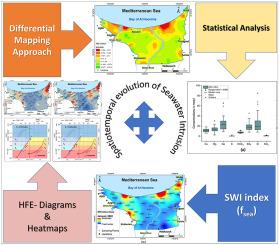
The impact of seawater intrusion on coastal aquifers is a major concern in managing groundwater resources. The unconfined coastal aquifer of Ghiss-Nekor, located in a semi-arid area, is particularly vulnerable to seawater intrusion (SWI) because of excessive groundwater pumping and climate change impacts. Therefore, the main goal of the present work is to track the spatiotemporal evolution of SWI in the Ghiss-Nekor aquifer by analyzing data from the years 2015 and 2022 using appropriate geochemical approaches. Accordingly, a range of geochemical techniques were employed, including the Piper diagram, Chadha's diagram, Gibbs diagram, Stiff diagram, major ions variation maps, Hydrochemical Facies Evolution Diagrams (HFE-D), and seawater fraction (fsea). As a result, Gibbs diagram clearly indicates the contribution of seawater to the salinization of the Ghiss-Nekor aquifer. Further information is provided by the Piper, Chadha, and Stiff diagrams, which reveal that 29%–38% of the wells studied display Na–Cl water type, a characteristic feature of seawater facies. Additionally, statistical analysis shows a significant increase in salinity levels between 2015 and 2022. Furthermore, the spatiotemporal analysis using the differential mapping technique (DMT) confirmed the increase of salinity, particularly near the shoreline. Additionally, the HFE-D showed that the region impacted by SWI increased from 14% to 20% between 2015 and 2022, and the maximum fsea value rose from 14.84% to 25.77% over the same time frame. Our findings reinforce the assumption that SWI is worsening over time in the Ghiss-Nekor aquifer. In summary, the techniques used in this study were effective in tracking the spatiotemporal evolution of SWI in the aquifer and in quantifying it. The results of this study can inform the development of effective strategies for managing SWI in coastal aquifers.

 求助内容:
求助内容: 应助结果提醒方式:


