无人机数字高程模型构建经验
IF 0.3
Q4 GEOCHEMISTRY & GEOPHYSICS
引用次数: 0
摘要
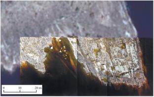
本文简要介绍了数字高程模型生成的现代途径和方法。重点是摄影测量模型生成方法:摄影测量本身依赖于一系列重叠的摄影图像。在我们的研究中,摄像机安装在无人驾驶飞行器(UAV)上。我们描述了生成数字高程模型的主要步骤,齿轮要求,图像捕获细节和使用的软件。最后,我们展示了如何创建拉多加湖北岸附近一个岛屿的局部数字高程模型。本文章由计算机程序翻译,如有差异,请以英文原文为准。
Experience of Constructing Digital Elevation Models with Unmanned Aerial Vehicles
This paper briefly reviews modern approaches and methods for generating digital elevation models. The focus is on photogrammetric model generation methods: photogrammetry itself relies on a series of overlapping photographic images. In our study, a camera was mounted on an unmanned aerial vehicle (UAV). We describe the major steps in generating digital elevation models, gear requirements, image capture details, and software used. Lastly, we show how we created a local digital elevation model of part of an island near the northern shore of Lake Ladoga.
求助全文
通过发布文献求助,成功后即可免费获取论文全文。
去求助
来源期刊
Seismic Instruments
GEOCHEMISTRY & GEOPHYSICS-
自引率
44.40%
发文量
45
期刊介绍:
Seismic Instruments is a journal devoted to the description of geophysical instruments used in seismic research. In addition to covering the actual instruments for registering seismic waves, substantial room is devoted to solving instrumental-methodological problems of geophysical monitoring, applying various methods that are used to search for earthquake precursors, to studying earthquake nucleation processes and to monitoring natural and technogenous processes. The description of the construction, working elements, and technical characteristics of the instruments, as well as some results of implementation of the instruments and interpretation of the results are given. Attention is paid to seismic monitoring data and earthquake catalog quality Analysis.
 求助内容:
求助内容: 应助结果提醒方式:


