{"title":"罗马晚期-拜占庭早期Leukos定居点,Karpathos,希腊:地质考古学、考古学和古地理","authors":"Karen L. Kleinspehn, Michael C. Nelson","doi":"10.1002/gea.21962","DOIUrl":null,"url":null,"abstract":"<p>This archeoseismologic study focuses on the Leukos settlement that thrived on the west coast of the forearc island of Karpathos in the 4th−6th centuries CE. The onshore site occupies the eastern rim of the offshore Karpathos Basin, the deepest Aegean basin, in a sector of the Hellenic forearc typically regarded as seismically insignificant. Investigations of faulting, sedimentary processes, and secondary earthquake effects (hydraulic fracturing, liquefaction, tilting, landslides) are integrated with observations of previously surveyed and newly discovered archeological remains to appraise syn- to post-Early Byzantine seismicity and establish a sequence of faulting. Calibrated radiocarbon dates, the first from Karpathos, indicate intermittent faulting and seismicity spanning the 4th−10th centuries CE, likely contributing to the early 7th-century CE abandonment of Leukos. The coseismic rupture of competent cobbles whose fractures are filled with fluidized sediment is an established paleoseismologic tool for recognizing earthquakes of magnitude <i>M</i><sub>w</sub> ≥ 6; this study extends that criterion to archeoseismology. This study underscores the need to evaluate land movements, sea-level fluctuations, and shoreline migration for coastal archeological sites. A plausible Late Roman paleogeography emerges in which Leukos occupied a contiguous peninsula rather than surrounding three modern harbors. This study encourages re-evaluation of seismic and tsunami hazards in the sector of the Hellenic forearc surrounding ancient Leukos and the Karpathos Basin.</p>","PeriodicalId":55117,"journal":{"name":"Geoarchaeology-An International Journal","volume":"38 5","pages":"588-614"},"PeriodicalIF":1.4000,"publicationDate":"2023-05-06","publicationTypes":"Journal Article","fieldsOfStudy":null,"isOpenAccess":false,"openAccessPdf":"https://onlinelibrary.wiley.com/doi/epdf/10.1002/gea.21962","citationCount":"0","resultStr":"{\"title\":\"Late Roman–Early Byzantine Leukos settlement, Karpathos, Greece: Geoarchaeology, archeoseismology, and paleogeography\",\"authors\":\"Karen L. Kleinspehn, Michael C. Nelson\",\"doi\":\"10.1002/gea.21962\",\"DOIUrl\":null,\"url\":null,\"abstract\":\"<p>This archeoseismologic study focuses on the Leukos settlement that thrived on the west coast of the forearc island of Karpathos in the 4th−6th centuries CE. The onshore site occupies the eastern rim of the offshore Karpathos Basin, the deepest Aegean basin, in a sector of the Hellenic forearc typically regarded as seismically insignificant. Investigations of faulting, sedimentary processes, and secondary earthquake effects (hydraulic fracturing, liquefaction, tilting, landslides) are integrated with observations of previously surveyed and newly discovered archeological remains to appraise syn- to post-Early Byzantine seismicity and establish a sequence of faulting. Calibrated radiocarbon dates, the first from Karpathos, indicate intermittent faulting and seismicity spanning the 4th−10th centuries CE, likely contributing to the early 7th-century CE abandonment of Leukos. The coseismic rupture of competent cobbles whose fractures are filled with fluidized sediment is an established paleoseismologic tool for recognizing earthquakes of magnitude <i>M</i><sub>w</sub> ≥ 6; this study extends that criterion to archeoseismology. This study underscores the need to evaluate land movements, sea-level fluctuations, and shoreline migration for coastal archeological sites. A plausible Late Roman paleogeography emerges in which Leukos occupied a contiguous peninsula rather than surrounding three modern harbors. This study encourages re-evaluation of seismic and tsunami hazards in the sector of the Hellenic forearc surrounding ancient Leukos and the Karpathos Basin.</p>\",\"PeriodicalId\":55117,\"journal\":{\"name\":\"Geoarchaeology-An International Journal\",\"volume\":\"38 5\",\"pages\":\"588-614\"},\"PeriodicalIF\":1.4000,\"publicationDate\":\"2023-05-06\",\"publicationTypes\":\"Journal Article\",\"fieldsOfStudy\":null,\"isOpenAccess\":false,\"openAccessPdf\":\"https://onlinelibrary.wiley.com/doi/epdf/10.1002/gea.21962\",\"citationCount\":\"0\",\"resultStr\":null,\"platform\":\"Semanticscholar\",\"paperid\":null,\"PeriodicalName\":\"Geoarchaeology-An International Journal\",\"FirstCategoryId\":\"89\",\"ListUrlMain\":\"https://onlinelibrary.wiley.com/doi/10.1002/gea.21962\",\"RegionNum\":3,\"RegionCategory\":\"地球科学\",\"ArticlePicture\":[],\"TitleCN\":null,\"AbstractTextCN\":null,\"PMCID\":null,\"EPubDate\":\"\",\"PubModel\":\"\",\"JCR\":\"0\",\"JCRName\":\"ARCHAEOLOGY\",\"Score\":null,\"Total\":0}","platform":"Semanticscholar","paperid":null,"PeriodicalName":"Geoarchaeology-An International Journal","FirstCategoryId":"89","ListUrlMain":"https://onlinelibrary.wiley.com/doi/10.1002/gea.21962","RegionNum":3,"RegionCategory":"地球科学","ArticlePicture":[],"TitleCN":null,"AbstractTextCN":null,"PMCID":null,"EPubDate":"","PubModel":"","JCR":"0","JCRName":"ARCHAEOLOGY","Score":null,"Total":0}
Late Roman–Early Byzantine Leukos settlement, Karpathos, Greece: Geoarchaeology, archeoseismology, and paleogeography
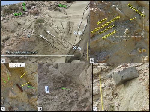
This archeoseismologic study focuses on the Leukos settlement that thrived on the west coast of the forearc island of Karpathos in the 4th−6th centuries CE. The onshore site occupies the eastern rim of the offshore Karpathos Basin, the deepest Aegean basin, in a sector of the Hellenic forearc typically regarded as seismically insignificant. Investigations of faulting, sedimentary processes, and secondary earthquake effects (hydraulic fracturing, liquefaction, tilting, landslides) are integrated with observations of previously surveyed and newly discovered archeological remains to appraise syn- to post-Early Byzantine seismicity and establish a sequence of faulting. Calibrated radiocarbon dates, the first from Karpathos, indicate intermittent faulting and seismicity spanning the 4th−10th centuries CE, likely contributing to the early 7th-century CE abandonment of Leukos. The coseismic rupture of competent cobbles whose fractures are filled with fluidized sediment is an established paleoseismologic tool for recognizing earthquakes of magnitude Mw ≥ 6; this study extends that criterion to archeoseismology. This study underscores the need to evaluate land movements, sea-level fluctuations, and shoreline migration for coastal archeological sites. A plausible Late Roman paleogeography emerges in which Leukos occupied a contiguous peninsula rather than surrounding three modern harbors. This study encourages re-evaluation of seismic and tsunami hazards in the sector of the Hellenic forearc surrounding ancient Leukos and the Karpathos Basin.
期刊介绍:
Geoarchaeology is an interdisciplinary journal published six times per year (in January, March, May, July, September and November). It presents the results of original research at the methodological and theoretical interface between archaeology and the geosciences and includes within its scope: interdisciplinary work focusing on understanding archaeological sites, their environmental context, and particularly site formation processes and how the analysis of sedimentary records can enhance our understanding of human activity in Quaternary environments. Manuscripts should examine the interrelationship between archaeology and the various disciplines within Quaternary science and the Earth Sciences more generally, including, for example: geology, geography, geomorphology, pedology, climatology, oceanography, geochemistry, geochronology, and geophysics. We also welcome papers that deal with the biological record of past human activity through the analysis of faunal and botanical remains and palaeoecological reconstructions that shed light on past human-environment interactions. The journal also welcomes manuscripts concerning the examination and geological context of human fossil remains as well as papers that employ analytical techniques to advance understanding of the composition and origin or material culture such as, for example, ceramics, metals, lithics, building stones, plasters, and cements. Such composition and provenance studies should be strongly grounded in their geological context through, for example, the systematic analysis of potential source materials.
 求助内容:
求助内容: 应助结果提醒方式:


