Molla Maru, Mohammed Assen, Asnake Mekuriaw, Arragaw Alemayehu
{"title":"埃塞俄比亚西部Alwero流域土地利用/覆被动态及其意义","authors":"Molla Maru, Mohammed Assen, Asnake Mekuriaw, Arragaw Alemayehu","doi":"10.1007/s40010-023-00820-4","DOIUrl":null,"url":null,"abstract":"<div><p>This study assesses land use and land cover (LULC) dynamics and their impacts in the Alwero watershed, in western Ethiopia. LULC datasets were created from Landsat imagery from 1973, 1987, 2002, and 2020 using ArcGIS 10.7® software. Results show that forest cover decreased from 52 to 30% between 1973 and 2020, mainly due to the expansion of cultivated land (small and large farms). Between 1973 and 2020, the number of small farms increased from 7.4 to 13.2%, with a net decrease in bare land (74.2%), grassland (19.7%), and forest (2.6%). Large farms increased from 1.5 to 7.2% between 2002 and 2020, with a net decrease in fallow (44%) and natural vegetation (19.4%). Fallow land shows a decreasing trend from 28% (1973) to 13% (2020), due to increased conversion to small farms (35.0%) and large farms (20.1%). The main causes of the changes are the rapid population growth and the large scale agricultural investments in the region. The deterioration of local people's living conditions and deforestation are the main impacts of LULC change in the study area. The innovative element of this study is the production of maps for large and small farms separately, which is useful for making decisions related to problems of large agricultural land investments (LALIs). The study concludes that the continued loss of forests will affect the government's development vision in general and mitigation of the negative impacts of climate change and climate variability in particular.</p></div>","PeriodicalId":744,"journal":{"name":"Proceedings of the National Academy of Sciences, India Section A: Physical Sciences","volume":"93 2","pages":"377 - 389"},"PeriodicalIF":1.2000,"publicationDate":"2023-03-13","publicationTypes":"Journal Article","fieldsOfStudy":null,"isOpenAccess":false,"openAccessPdf":"","citationCount":"1","resultStr":"{\"title\":\"Land Use/Cover Dynamics and its Implication in Alwero Watershed, Western Ethiopia\",\"authors\":\"Molla Maru, Mohammed Assen, Asnake Mekuriaw, Arragaw Alemayehu\",\"doi\":\"10.1007/s40010-023-00820-4\",\"DOIUrl\":null,\"url\":null,\"abstract\":\"<div><p>This study assesses land use and land cover (LULC) dynamics and their impacts in the Alwero watershed, in western Ethiopia. LULC datasets were created from Landsat imagery from 1973, 1987, 2002, and 2020 using ArcGIS 10.7® software. Results show that forest cover decreased from 52 to 30% between 1973 and 2020, mainly due to the expansion of cultivated land (small and large farms). Between 1973 and 2020, the number of small farms increased from 7.4 to 13.2%, with a net decrease in bare land (74.2%), grassland (19.7%), and forest (2.6%). Large farms increased from 1.5 to 7.2% between 2002 and 2020, with a net decrease in fallow (44%) and natural vegetation (19.4%). Fallow land shows a decreasing trend from 28% (1973) to 13% (2020), due to increased conversion to small farms (35.0%) and large farms (20.1%). The main causes of the changes are the rapid population growth and the large scale agricultural investments in the region. The deterioration of local people's living conditions and deforestation are the main impacts of LULC change in the study area. The innovative element of this study is the production of maps for large and small farms separately, which is useful for making decisions related to problems of large agricultural land investments (LALIs). The study concludes that the continued loss of forests will affect the government's development vision in general and mitigation of the negative impacts of climate change and climate variability in particular.</p></div>\",\"PeriodicalId\":744,\"journal\":{\"name\":\"Proceedings of the National Academy of Sciences, India Section A: Physical Sciences\",\"volume\":\"93 2\",\"pages\":\"377 - 389\"},\"PeriodicalIF\":1.2000,\"publicationDate\":\"2023-03-13\",\"publicationTypes\":\"Journal Article\",\"fieldsOfStudy\":null,\"isOpenAccess\":false,\"openAccessPdf\":\"\",\"citationCount\":\"1\",\"resultStr\":null,\"platform\":\"Semanticscholar\",\"paperid\":null,\"PeriodicalName\":\"Proceedings of the National Academy of Sciences, India Section A: Physical Sciences\",\"FirstCategoryId\":\"103\",\"ListUrlMain\":\"https://link.springer.com/article/10.1007/s40010-023-00820-4\",\"RegionNum\":4,\"RegionCategory\":\"综合性期刊\",\"ArticlePicture\":[],\"TitleCN\":null,\"AbstractTextCN\":null,\"PMCID\":null,\"EPubDate\":\"\",\"PubModel\":\"\",\"JCR\":\"Q3\",\"JCRName\":\"MULTIDISCIPLINARY SCIENCES\",\"Score\":null,\"Total\":0}","platform":"Semanticscholar","paperid":null,"PeriodicalName":"Proceedings of the National Academy of Sciences, India Section A: Physical Sciences","FirstCategoryId":"103","ListUrlMain":"https://link.springer.com/article/10.1007/s40010-023-00820-4","RegionNum":4,"RegionCategory":"综合性期刊","ArticlePicture":[],"TitleCN":null,"AbstractTextCN":null,"PMCID":null,"EPubDate":"","PubModel":"","JCR":"Q3","JCRName":"MULTIDISCIPLINARY SCIENCES","Score":null,"Total":0}
Land Use/Cover Dynamics and its Implication in Alwero Watershed, Western Ethiopia
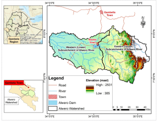
This study assesses land use and land cover (LULC) dynamics and their impacts in the Alwero watershed, in western Ethiopia. LULC datasets were created from Landsat imagery from 1973, 1987, 2002, and 2020 using ArcGIS 10.7® software. Results show that forest cover decreased from 52 to 30% between 1973 and 2020, mainly due to the expansion of cultivated land (small and large farms). Between 1973 and 2020, the number of small farms increased from 7.4 to 13.2%, with a net decrease in bare land (74.2%), grassland (19.7%), and forest (2.6%). Large farms increased from 1.5 to 7.2% between 2002 and 2020, with a net decrease in fallow (44%) and natural vegetation (19.4%). Fallow land shows a decreasing trend from 28% (1973) to 13% (2020), due to increased conversion to small farms (35.0%) and large farms (20.1%). The main causes of the changes are the rapid population growth and the large scale agricultural investments in the region. The deterioration of local people's living conditions and deforestation are the main impacts of LULC change in the study area. The innovative element of this study is the production of maps for large and small farms separately, which is useful for making decisions related to problems of large agricultural land investments (LALIs). The study concludes that the continued loss of forests will affect the government's development vision in general and mitigation of the negative impacts of climate change and climate variability in particular.
 求助内容:
求助内容: 应助结果提醒方式:


