Liliane Morais, António Lopes, Jorge Rocha, Paulo Jorge Nogueira
{"title":"超越通常的地理尺度分析:对医疗管理和城市规划的影响","authors":"Liliane Morais, António Lopes, Jorge Rocha, Paulo Jorge Nogueira","doi":"10.1159/000527162","DOIUrl":null,"url":null,"abstract":"<p><strong>Introduction: </strong>In the context of climate emergency, advances in geographic information systems, geocoding, and geomedicine allow us to go beyond the conventional usual scales and be aligned with people's needs, improving knowledge and accuracy of the spatial pattern of health outcomes. This study shows that the geographical scale of analysis affects the interpretation of health outcomes.</p><p><strong>Methods: </strong>All mortality that occurred in Portugal in 2014-2017 was geocoded. From 435,291 addresses, 412,608 were geocoded with success. As an example, we use the spatial patterns of the elderly's heat-related cardiorespiratory mortality.</p><p><strong>Results: </strong>It is shown: (i) it is possible to have high quality and accuracy of spatial data used in health outcomes analysis; (ii) how geographic scales reveal different degrees of detail in health outcomes analysis; (iii) the neighbourhood scale revealed different patterns of cardiorespiratory mortality from the usually available scale (parish).</p><p><strong>Discussion: </strong>Our findings suggest the relevance of geocoding health outcomes with a finer scale in tackling the challenges of the healthcare sector, and in support of planning decision-making, closely matching citizens' needs. Without running the risk of losing potentially major prospects, better healthcare management is achievable, with optimal resource allocation, and improved detailed and informed policymaking, allowing enhanced climate health equity in cities promotion.</p>","PeriodicalId":37244,"journal":{"name":"Portuguese Journal of Public Health","volume":"40 1","pages":"140-154"},"PeriodicalIF":0.7000,"publicationDate":"2023-01-10","publicationTypes":"Journal Article","fieldsOfStudy":null,"isOpenAccess":false,"openAccessPdf":"https://www.ncbi.nlm.nih.gov/pmc/articles/PMC11320098/pdf/","citationCount":"0","resultStr":"{\"title\":\"Beyond Usual Geographical Scales of Analysis: Implications for Healthcare Management and Urban Planning.\",\"authors\":\"Liliane Morais, António Lopes, Jorge Rocha, Paulo Jorge Nogueira\",\"doi\":\"10.1159/000527162\",\"DOIUrl\":null,\"url\":null,\"abstract\":\"<p><strong>Introduction: </strong>In the context of climate emergency, advances in geographic information systems, geocoding, and geomedicine allow us to go beyond the conventional usual scales and be aligned with people's needs, improving knowledge and accuracy of the spatial pattern of health outcomes. This study shows that the geographical scale of analysis affects the interpretation of health outcomes.</p><p><strong>Methods: </strong>All mortality that occurred in Portugal in 2014-2017 was geocoded. From 435,291 addresses, 412,608 were geocoded with success. As an example, we use the spatial patterns of the elderly's heat-related cardiorespiratory mortality.</p><p><strong>Results: </strong>It is shown: (i) it is possible to have high quality and accuracy of spatial data used in health outcomes analysis; (ii) how geographic scales reveal different degrees of detail in health outcomes analysis; (iii) the neighbourhood scale revealed different patterns of cardiorespiratory mortality from the usually available scale (parish).</p><p><strong>Discussion: </strong>Our findings suggest the relevance of geocoding health outcomes with a finer scale in tackling the challenges of the healthcare sector, and in support of planning decision-making, closely matching citizens' needs. Without running the risk of losing potentially major prospects, better healthcare management is achievable, with optimal resource allocation, and improved detailed and informed policymaking, allowing enhanced climate health equity in cities promotion.</p>\",\"PeriodicalId\":37244,\"journal\":{\"name\":\"Portuguese Journal of Public Health\",\"volume\":\"40 1\",\"pages\":\"140-154\"},\"PeriodicalIF\":0.7000,\"publicationDate\":\"2023-01-10\",\"publicationTypes\":\"Journal Article\",\"fieldsOfStudy\":null,\"isOpenAccess\":false,\"openAccessPdf\":\"https://www.ncbi.nlm.nih.gov/pmc/articles/PMC11320098/pdf/\",\"citationCount\":\"0\",\"resultStr\":null,\"platform\":\"Semanticscholar\",\"paperid\":null,\"PeriodicalName\":\"Portuguese Journal of Public Health\",\"FirstCategoryId\":\"1085\",\"ListUrlMain\":\"https://doi.org/10.1159/000527162\",\"RegionNum\":0,\"RegionCategory\":null,\"ArticlePicture\":[],\"TitleCN\":null,\"AbstractTextCN\":null,\"PMCID\":null,\"EPubDate\":\"2023/2/1 0:00:00\",\"PubModel\":\"eCollection\",\"JCR\":\"Q3\",\"JCRName\":\"Medicine\",\"Score\":null,\"Total\":0}","platform":"Semanticscholar","paperid":null,"PeriodicalName":"Portuguese Journal of Public Health","FirstCategoryId":"1085","ListUrlMain":"https://doi.org/10.1159/000527162","RegionNum":0,"RegionCategory":null,"ArticlePicture":[],"TitleCN":null,"AbstractTextCN":null,"PMCID":null,"EPubDate":"2023/2/1 0:00:00","PubModel":"eCollection","JCR":"Q3","JCRName":"Medicine","Score":null,"Total":0}
Beyond Usual Geographical Scales of Analysis: Implications for Healthcare Management and Urban Planning.
Introduction: In the context of climate emergency, advances in geographic information systems, geocoding, and geomedicine allow us to go beyond the conventional usual scales and be aligned with people's needs, improving knowledge and accuracy of the spatial pattern of health outcomes. This study shows that the geographical scale of analysis affects the interpretation of health outcomes.
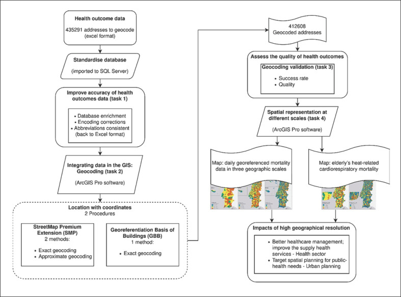
Methods: All mortality that occurred in Portugal in 2014-2017 was geocoded. From 435,291 addresses, 412,608 were geocoded with success. As an example, we use the spatial patterns of the elderly's heat-related cardiorespiratory mortality.
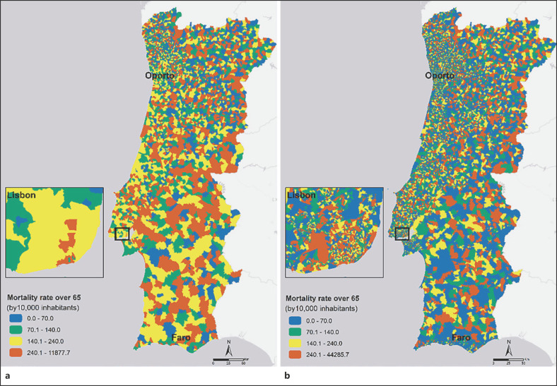
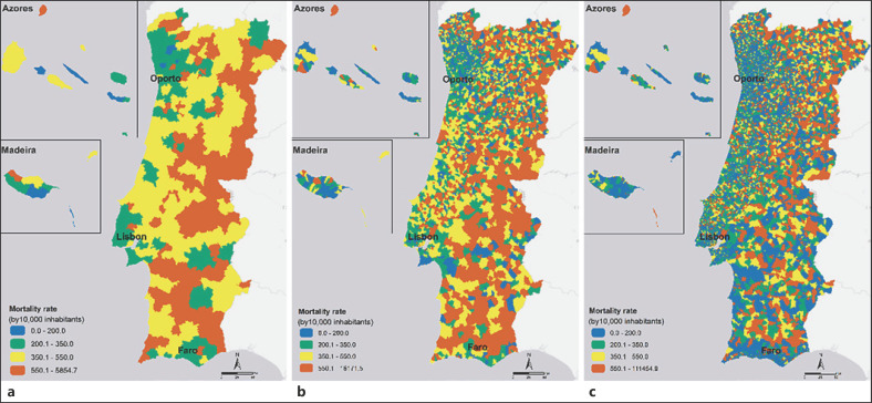
Results: It is shown: (i) it is possible to have high quality and accuracy of spatial data used in health outcomes analysis; (ii) how geographic scales reveal different degrees of detail in health outcomes analysis; (iii) the neighbourhood scale revealed different patterns of cardiorespiratory mortality from the usually available scale (parish).
Discussion: Our findings suggest the relevance of geocoding health outcomes with a finer scale in tackling the challenges of the healthcare sector, and in support of planning decision-making, closely matching citizens' needs. Without running the risk of losing potentially major prospects, better healthcare management is achievable, with optimal resource allocation, and improved detailed and informed policymaking, allowing enhanced climate health equity in cities promotion.

 求助内容:
求助内容: 应助结果提醒方式:


