Andrea J. Tirrell, Aaron E. Putnam, Michael I. J. Cianchette, Jacquelyn L. Gill
{"title":"利用摄影测量在稀有和受威胁的植物群落中创建虚拟的永久地块","authors":"Andrea J. Tirrell, Aaron E. Putnam, Michael I. J. Cianchette, Jacquelyn L. Gill","doi":"10.1002/aps3.11534","DOIUrl":null,"url":null,"abstract":"<div>\n \n \n <section>\n \n <h3> Premise</h3>\n \n <p>Many plant communities across the world are undergoing changes due to climate change, human disturbance, and other threats. These community-level changes are often tracked with the use of permanent vegetative plots, but this approach is not always feasible. As an alternative, we propose using photogrammetry, specifically photograph-based digital surface models (DSMs) developed using structure-from-motion, to establish virtual permanent plots in plant communities where the use of permanent structures may not be possible.</p>\n </section>\n \n <section>\n \n <h3> Methods</h3>\n \n <p>In 2021 and 2022, we took iPhone photographs to record species presence in 1-m<sup>2</sup> plots distributed across alpine communities in the northeastern United States. We then compared field estimates of percent coverage with coverage estimated using DSMs.</p>\n </section>\n \n <section>\n \n <h3> Results</h3>\n \n <p>Digital surface models can provide effective, minimally invasive, and permanent records of plant species presence and percent coverage, while also allowing managers to mark survey locations virtually for long-term monitoring. We found that percent coverage estimated from DSMs did not differ from field estimates for most species and substrates.</p>\n </section>\n \n <section>\n \n <h3> Discussion</h3>\n \n <p>In order to continue surveying efforts in areas where permanent structures or other surveying methods are not feasible, photogrammetry and structure-from-motion methods can provide a low-cost approach that allows agencies to accurately survey and record sensitive plant communities through time.</p>\n </section>\n </div>","PeriodicalId":8022,"journal":{"name":"Applications in Plant Sciences","volume":"11 5","pages":""},"PeriodicalIF":2.7000,"publicationDate":"2023-08-18","publicationTypes":"Journal Article","fieldsOfStudy":null,"isOpenAccess":false,"openAccessPdf":"","citationCount":"1","resultStr":"{\"title\":\"Using photogrammetry to create virtual permanent plots in rare and threatened plant communities\",\"authors\":\"Andrea J. Tirrell, Aaron E. Putnam, Michael I. J. Cianchette, Jacquelyn L. Gill\",\"doi\":\"10.1002/aps3.11534\",\"DOIUrl\":null,\"url\":null,\"abstract\":\"<div>\\n \\n \\n <section>\\n \\n <h3> Premise</h3>\\n \\n <p>Many plant communities across the world are undergoing changes due to climate change, human disturbance, and other threats. These community-level changes are often tracked with the use of permanent vegetative plots, but this approach is not always feasible. As an alternative, we propose using photogrammetry, specifically photograph-based digital surface models (DSMs) developed using structure-from-motion, to establish virtual permanent plots in plant communities where the use of permanent structures may not be possible.</p>\\n </section>\\n \\n <section>\\n \\n <h3> Methods</h3>\\n \\n <p>In 2021 and 2022, we took iPhone photographs to record species presence in 1-m<sup>2</sup> plots distributed across alpine communities in the northeastern United States. We then compared field estimates of percent coverage with coverage estimated using DSMs.</p>\\n </section>\\n \\n <section>\\n \\n <h3> Results</h3>\\n \\n <p>Digital surface models can provide effective, minimally invasive, and permanent records of plant species presence and percent coverage, while also allowing managers to mark survey locations virtually for long-term monitoring. We found that percent coverage estimated from DSMs did not differ from field estimates for most species and substrates.</p>\\n </section>\\n \\n <section>\\n \\n <h3> Discussion</h3>\\n \\n <p>In order to continue surveying efforts in areas where permanent structures or other surveying methods are not feasible, photogrammetry and structure-from-motion methods can provide a low-cost approach that allows agencies to accurately survey and record sensitive plant communities through time.</p>\\n </section>\\n </div>\",\"PeriodicalId\":8022,\"journal\":{\"name\":\"Applications in Plant Sciences\",\"volume\":\"11 5\",\"pages\":\"\"},\"PeriodicalIF\":2.7000,\"publicationDate\":\"2023-08-18\",\"publicationTypes\":\"Journal Article\",\"fieldsOfStudy\":null,\"isOpenAccess\":false,\"openAccessPdf\":\"\",\"citationCount\":\"1\",\"resultStr\":null,\"platform\":\"Semanticscholar\",\"paperid\":null,\"PeriodicalName\":\"Applications in Plant Sciences\",\"FirstCategoryId\":\"99\",\"ListUrlMain\":\"https://onlinelibrary.wiley.com/doi/10.1002/aps3.11534\",\"RegionNum\":3,\"RegionCategory\":\"生物学\",\"ArticlePicture\":[],\"TitleCN\":null,\"AbstractTextCN\":null,\"PMCID\":null,\"EPubDate\":\"\",\"PubModel\":\"\",\"JCR\":\"Q2\",\"JCRName\":\"PLANT SCIENCES\",\"Score\":null,\"Total\":0}","platform":"Semanticscholar","paperid":null,"PeriodicalName":"Applications in Plant Sciences","FirstCategoryId":"99","ListUrlMain":"https://onlinelibrary.wiley.com/doi/10.1002/aps3.11534","RegionNum":3,"RegionCategory":"生物学","ArticlePicture":[],"TitleCN":null,"AbstractTextCN":null,"PMCID":null,"EPubDate":"","PubModel":"","JCR":"Q2","JCRName":"PLANT SCIENCES","Score":null,"Total":0}
Using photogrammetry to create virtual permanent plots in rare and threatened plant communities
Premise
Many plant communities across the world are undergoing changes due to climate change, human disturbance, and other threats. These community-level changes are often tracked with the use of permanent vegetative plots, but this approach is not always feasible. As an alternative, we propose using photogrammetry, specifically photograph-based digital surface models (DSMs) developed using structure-from-motion, to establish virtual permanent plots in plant communities where the use of permanent structures may not be possible.
Methods
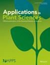
In 2021 and 2022, we took iPhone photographs to record species presence in 1-m2 plots distributed across alpine communities in the northeastern United States. We then compared field estimates of percent coverage with coverage estimated using DSMs.
Results
Digital surface models can provide effective, minimally invasive, and permanent records of plant species presence and percent coverage, while also allowing managers to mark survey locations virtually for long-term monitoring. We found that percent coverage estimated from DSMs did not differ from field estimates for most species and substrates.
Discussion
In order to continue surveying efforts in areas where permanent structures or other surveying methods are not feasible, photogrammetry and structure-from-motion methods can provide a low-cost approach that allows agencies to accurately survey and record sensitive plant communities through time.
期刊介绍:
Applications in Plant Sciences (APPS) is a monthly, peer-reviewed, open access journal promoting the rapid dissemination of newly developed, innovative tools and protocols in all areas of the plant sciences, including genetics, structure, function, development, evolution, systematics, and ecology. Given the rapid progress today in technology and its application in the plant sciences, the goal of APPS is to foster communication within the plant science community to advance scientific research. APPS is a publication of the Botanical Society of America, originating in 2009 as the American Journal of Botany''s online-only section, AJB Primer Notes & Protocols in the Plant Sciences.
APPS publishes the following types of articles: (1) Protocol Notes describe new methods and technological advancements; (2) Genomic Resources Articles characterize the development and demonstrate the usefulness of newly developed genomic resources, including transcriptomes; (3) Software Notes detail new software applications; (4) Application Articles illustrate the application of a new protocol, method, or software application within the context of a larger study; (5) Review Articles evaluate available techniques, methods, or protocols; (6) Primer Notes report novel genetic markers with evidence of wide applicability.
 求助内容:
求助内容: 应助结果提醒方式:


