地貌对红树林高度的控制及阻碍其发育的因素
IF 2.6
3区 地球科学
Q1 MARINE & FRESHWATER BIOLOGY
引用次数: 0
摘要
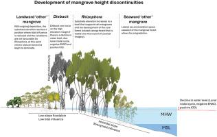
当基质条件长时间处于最佳状态时,红树林的高度达到最大值。沿着海岸正常轮廓的树冠高度的突然变化可以创造出“墙状”的特征,在那里,高大的森林被所谓的“高度不连续”所包围。“考虑到全国范围内的红树林,这项研究使用激光雷达衍生的树冠高度模型来识别澳大利亚各地的高度不连续性,负责的物种和潜在原因。”在西鳄鱼河、Leichhardt河和Starcke河以及道格拉斯港发现了明显的高度不连续性,其中以根藻为主的高大红树林区位于潮间带斜坡的最高海拔,树木高度在向陆边缘急剧下降了约15 m。在潮间带的最高位置有较短的陆生森林,主要是Avicennia和ceriiops。这种不连续性标志着森林结构的边界以及基岩高程和潮汐淹没的变化。在高大森林向海的一些地点发生了递进,表明有充足的横向容纳空间。36年的归一化植被指数(NDVI)分析显示,高根霉带NDVI最高。在高度不连续的向陆缘处观察到枯死的根茎或稀疏的红树林。我们的研究结果强调,高度不连续标志着最大生物量储存区,由于沉积和潮汐淹没模式驱动的次优条件,可能会过渡到矮树,稀疏森林和枯死区。这些结果强调了物种、沉积速率、长阶段潮汐循环和气候事件之间复杂的相互作用,这些相互作用会影响红树林的生长、枯死和碳封存。本文章由计算机程序翻译,如有差异,请以英文原文为准。
Geomorphological control on mangrove height and factors arresting their development
Mangroves reach maximum height when substrate conditions are optimal for extended periods. A sudden change in canopy height along a shore normal profile can create a ‘wall-like’ feature, where tall forest is bounded by what is known as a ‘height discontinuity.’ Considering mangrove forests at a national scale, this study uses LiDAR-derived canopy height models to identify height discontinuities across Australia, the species responsible and potential causes. Notable height discontinuities were identified at the West Alligator, Leichhardt and Starcke Rivers and Port Douglas, where tall mangrove zones dominated by Rhizophora were located at the highest elevations of the intertidal slope and tree heights decreased sharply by ∼15 m at the landward margin. Shorter landward forests, dominated by Avicennia and Ceriops, were at the highest intertidal positions. This discontinuity marks a boundary in forest structure and a shift in substrate elevation and tidal inundation. Progradation occurred at some sites seaward of the tall forest suggesting ample lateral accommodation space. Analyses of normalized difference vegetation index (NDVI) across 36 years revealed highest NDVI in tall Rhizophora zones. Dead Rhizophora or sparse mangroves were observed at the landward margin of the height discontinuity. Our findings highlight that height discontinuities mark zones of maximum biomass storage, with transition to shorter trees, sparse forests and dieback zones likely due to sub-optimal conditions driven by sedimentation and tidal inundation patterns. These results underscore the complex interplay between species, sedimentation rates, long-phase tidal cycles and climatic events in influencing mangrove growth, dieback, and carbon sequestration.
求助全文
通过发布文献求助,成功后即可免费获取论文全文。
去求助
来源期刊
CiteScore
5.60
自引率
7.10%
发文量
374
审稿时长
9 months
期刊介绍:
Estuarine, Coastal and Shelf Science is an international multidisciplinary journal devoted to the analysis of saline water phenomena ranging from the outer edge of the continental shelf to the upper limits of the tidal zone. The journal provides a unique forum, unifying the multidisciplinary approaches to the study of the oceanography of estuaries, coastal zones, and continental shelf seas. It features original research papers, review papers and short communications treating such disciplines as zoology, botany, geology, sedimentology, physical oceanography.
 求助内容:
求助内容: 应助结果提醒方式:


