全波形层析成像模型的克拉通边界探测揭示了与关键金属矿床的联系

IF 8.9 1区 地球科学 Q1 GEOSCIENCES, MULTIDISCIPLINARY
Hojat Shirmard , Ben Mather , Ehsan Farahbakhsh , Karol Czarnota , R. Dietmar Müller
{"title":"全波形层析成像模型的克拉通边界探测揭示了与关键金属矿床的联系","authors":"Hojat Shirmard ,&nbsp;Ben Mather ,&nbsp;Ehsan Farahbakhsh ,&nbsp;Karol Czarnota ,&nbsp;R. Dietmar Müller","doi":"10.1016/j.gsf.2025.102176","DOIUrl":null,"url":null,"abstract":"<div><div>Craton margins play a crucial role in mineral exploration as they host faults, fractures, and shear zones that facilitate hydrothermal fluid movement, transporting and depositing dissolved metals into valuable mineral deposits. We use the high-resolution full-waveform seismic inversion model REVEAL to extract horizontal shear wave velocity (<em>V</em><sub>SH</sub>), vertical shear wave velocity (<em>V</em><sub>SV</sub>), and isotropic P-wave velocity (<em>V</em><sub>P</sub>) across depth slices from 150 to 200 km, a range that captures most cratonic lithosphere based on tectonic age and lithospheric thickness analyses. Machine learning, applied through clustered maps, demonstrates that <em>V</em><sub>SH</sub> effectively delineates craton boundaries, aligning with target mineral deposits, including iron oxide copper–gold (IOCG) and sediment-hosted lead, zinc, and copper deposits. These boundaries are characterized by high horizontal shear velocities (4.58–4.68 km/s), and trace the edges of cratons, accreted passive margins, orogens, and thick volcanic arcs. Using published thermal and lithospheric thickness models, we distinguish cratons from other thick lithospheric features and identify their edges and associated deposits. Our results show that ∼85 % of the total metal content (Cu + Pb + Zn) in target deposits lies within ∼120 km of high-velocity cluster boundaries identified as craton edges. Near-craton deposits reveal ∼80 % of the total metal content within ∼90 km of craton boundaries. The weighted cumulative distribution function shows a steeper gradient in metal content closer to craton boundaries, indicating higher concentrations near these tectonic features. Focusing on just 16 % of Earth’s continental areas can reveal over 80 % of known target deposits, highlighting the significance of craton boundaries quantitatively mapped in this study.</div></div>","PeriodicalId":12711,"journal":{"name":"Geoscience frontiers","volume":"16 6","pages":"Article 102176"},"PeriodicalIF":8.9000,"publicationDate":"2025-10-02","publicationTypes":"Journal Article","fieldsOfStudy":null,"isOpenAccess":false,"openAccessPdf":"","citationCount":"0","resultStr":"{\"title\":\"Craton boundary detection from full-waveform tomography model reveals links to critical metal deposits\",\"authors\":\"Hojat Shirmard ,&nbsp;Ben Mather ,&nbsp;Ehsan Farahbakhsh ,&nbsp;Karol Czarnota ,&nbsp;R. Dietmar Müller\",\"doi\":\"10.1016/j.gsf.2025.102176\",\"DOIUrl\":null,\"url\":null,\"abstract\":\"<div><div>Craton margins play a crucial role in mineral exploration as they host faults, fractures, and shear zones that facilitate hydrothermal fluid movement, transporting and depositing dissolved metals into valuable mineral deposits. We use the high-resolution full-waveform seismic inversion model REVEAL to extract horizontal shear wave velocity (<em>V</em><sub>SH</sub>), vertical shear wave velocity (<em>V</em><sub>SV</sub>), and isotropic P-wave velocity (<em>V</em><sub>P</sub>) across depth slices from 150 to 200 km, a range that captures most cratonic lithosphere based on tectonic age and lithospheric thickness analyses. Machine learning, applied through clustered maps, demonstrates that <em>V</em><sub>SH</sub> effectively delineates craton boundaries, aligning with target mineral deposits, including iron oxide copper–gold (IOCG) and sediment-hosted lead, zinc, and copper deposits. These boundaries are characterized by high horizontal shear velocities (4.58–4.68 km/s), and trace the edges of cratons, accreted passive margins, orogens, and thick volcanic arcs. Using published thermal and lithospheric thickness models, we distinguish cratons from other thick lithospheric features and identify their edges and associated deposits. Our results show that ∼85 % of the total metal content (Cu + Pb + Zn) in target deposits lies within ∼120 km of high-velocity cluster boundaries identified as craton edges. Near-craton deposits reveal ∼80 % of the total metal content within ∼90 km of craton boundaries. The weighted cumulative distribution function shows a steeper gradient in metal content closer to craton boundaries, indicating higher concentrations near these tectonic features. Focusing on just 16 % of Earth’s continental areas can reveal over 80 % of known target deposits, highlighting the significance of craton boundaries quantitatively mapped in this study.</div></div>\",\"PeriodicalId\":12711,\"journal\":{\"name\":\"Geoscience frontiers\",\"volume\":\"16 6\",\"pages\":\"Article 102176\"},\"PeriodicalIF\":8.9000,\"publicationDate\":\"2025-10-02\",\"publicationTypes\":\"Journal Article\",\"fieldsOfStudy\":null,\"isOpenAccess\":false,\"openAccessPdf\":\"\",\"citationCount\":\"0\",\"resultStr\":null,\"platform\":\"Semanticscholar\",\"paperid\":null,\"PeriodicalName\":\"Geoscience frontiers\",\"FirstCategoryId\":\"89\",\"ListUrlMain\":\"https://www.sciencedirect.com/science/article/pii/S1674987125001811\",\"RegionNum\":1,\"RegionCategory\":\"地球科学\",\"ArticlePicture\":[],\"TitleCN\":null,\"AbstractTextCN\":null,\"PMCID\":null,\"EPubDate\":\"\",\"PubModel\":\"\",\"JCR\":\"Q1\",\"JCRName\":\"GEOSCIENCES, MULTIDISCIPLINARY\",\"Score\":null,\"Total\":0}","platform":"Semanticscholar","paperid":null,"PeriodicalName":"Geoscience frontiers","FirstCategoryId":"89","ListUrlMain":"https://www.sciencedirect.com/science/article/pii/S1674987125001811","RegionNum":1,"RegionCategory":"地球科学","ArticlePicture":[],"TitleCN":null,"AbstractTextCN":null,"PMCID":null,"EPubDate":"","PubModel":"","JCR":"Q1","JCRName":"GEOSCIENCES, MULTIDISCIPLINARY","Score":null,"Total":0}
引用次数: 0

摘要

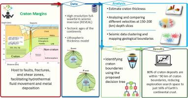
克拉通边缘在矿产勘探中起着至关重要的作用,因为它们拥有断层、裂缝和剪切带,有利于热液流体的运动,将溶解的金属运输并沉积成有价值的矿床。利用高分辨率全波形地震反演模型REVEAL在150 ~ 200 km的深度切片上提取水平横波速度(VSH)、垂直横波速度(VSV)和各向同性纵波速度(VP),根据构造年龄和岩石圈厚度分析,这一范围可以捕获大部分克拉通岩石圈。通过聚类地图应用的机器学习表明,VSH有效地划定了克拉通的边界,并与目标矿床对齐,包括氧化铁铜金(IOCG)和沉积物中的铅、锌和铜矿床。这些边界具有高水平剪切速度(4.58 ~ 4.68 km/s)的特征,并可追溯克拉通、被动增生边缘、造山带和厚火山弧的边缘。利用已发表的热模型和岩石圈厚度模型,我们将克拉通与其他厚岩石圈特征区分开来,并识别其边缘和伴生矿床。我们的研究结果表明,目标矿床中总金属含量(Cu + Pb + Zn)的~ 85%位于被确定为克拉通边缘的高速簇边界~ 120公里内。近克拉通矿床显示,在克拉通边界~ 90公里范围内的金属含量占总金属含量的~ 80%。加权累积分布函数表明,靠近克拉通边界的金属含量梯度较大,表明这些构造特征附近的金属含量较高。仅关注地球16%的大陆区域,就可以揭示超过80%的已知目标矿床,突出了克拉通边界在本研究中定量绘制的重要性。
本文章由计算机程序翻译,如有差异,请以英文原文为准。

Craton boundary detection from full-waveform tomography model reveals links to critical metal deposits

Craton boundary detection from full-waveform tomography model reveals links to critical metal deposits
Craton margins play a crucial role in mineral exploration as they host faults, fractures, and shear zones that facilitate hydrothermal fluid movement, transporting and depositing dissolved metals into valuable mineral deposits. We use the high-resolution full-waveform seismic inversion model REVEAL to extract horizontal shear wave velocity (VSH), vertical shear wave velocity (VSV), and isotropic P-wave velocity (VP) across depth slices from 150 to 200 km, a range that captures most cratonic lithosphere based on tectonic age and lithospheric thickness analyses. Machine learning, applied through clustered maps, demonstrates that VSH effectively delineates craton boundaries, aligning with target mineral deposits, including iron oxide copper–gold (IOCG) and sediment-hosted lead, zinc, and copper deposits. These boundaries are characterized by high horizontal shear velocities (4.58–4.68 km/s), and trace the edges of cratons, accreted passive margins, orogens, and thick volcanic arcs. Using published thermal and lithospheric thickness models, we distinguish cratons from other thick lithospheric features and identify their edges and associated deposits. Our results show that ∼85 % of the total metal content (Cu + Pb + Zn) in target deposits lies within ∼120 km of high-velocity cluster boundaries identified as craton edges. Near-craton deposits reveal ∼80 % of the total metal content within ∼90 km of craton boundaries. The weighted cumulative distribution function shows a steeper gradient in metal content closer to craton boundaries, indicating higher concentrations near these tectonic features. Focusing on just 16 % of Earth’s continental areas can reveal over 80 % of known target deposits, highlighting the significance of craton boundaries quantitatively mapped in this study.
求助全文
通过发布文献求助,成功后即可免费获取论文全文。 去求助
来源期刊
Geoscience frontiers
Geoscience frontiers Earth and Planetary Sciences-General Earth and Planetary Sciences
CiteScore
17.80
自引率
3.40%
发文量
147
审稿时长
35 days
期刊介绍: Geoscience Frontiers (GSF) is the Journal of China University of Geosciences (Beijing) and Peking University. It publishes peer-reviewed research articles and reviews in interdisciplinary fields of Earth and Planetary Sciences. GSF covers various research areas including petrology and geochemistry, lithospheric architecture and mantle dynamics, global tectonics, economic geology and fuel exploration, geophysics, stratigraphy and paleontology, environmental and engineering geology, astrogeology, and the nexus of resources-energy-emissions-climate under Sustainable Development Goals. The journal aims to bridge innovative, provocative, and challenging concepts and models in these fields, providing insights on correlations and evolution.
×
引用
GB/T 7714-2015
复制
MLA
复制
APA
复制
导出至
BibTeX EndNote RefMan NoteFirst NoteExpress
×
提示
您的信息不完整,为了账户安全,请先补充。
现在去补充
×
提示
您因"违规操作"
具体请查看互助需知
我知道了
×
提示
确定
请完成安全验证×
copy
已复制链接
快去分享给好友吧!
我知道了
右上角分享
点击右上角分享
0
联系我们:info@booksci.cn Book学术提供免费学术资源搜索服务,方便国内外学者检索中英文文献。致力于提供最便捷和优质的服务体验。 Copyright © 2023 布克学术 All rights reserved.
京ICP备2023020795号-1
ghs 京公网安备 11010802042870号
Book学术文献互助
Book学术文献互助群
群 号:604180095
Book学术官方微信