{"title":"在印度东海岸进行放射性矿物勘探的热遥感和地面测量相结合的方法","authors":"Samikshya Mohanty, Santanu Dinda, Nimesh Kotadia, Debashish Sengupta, Biswajit Bera, Somnath Adak","doi":"10.1007/s12665-025-12554-0","DOIUrl":null,"url":null,"abstract":"<div><p>This study investigates the potential of thermal remote sensing for delineating radioactive mineral deposits by examining the relationship between land surface temperature and the presence of these minerals. The underlying hypothesis is that radioactive decay, while typically generating heat, can contribute to detectable thermal anomalies in areas with significant concentrations of radioactive minerals. Utilizing Landsat 8 Operational Land Imager, Land Surface Temperature (LST) patterns are analysed in the coastal region, Podampata, Odisha, eastern coast of India and compared with occurrences of radioactive minerals. The Land Surface Temperature in the study area ranges from 19.4 °C to 28.34 °C. Preliminary findings indicate a positive correlation between LST and the presence of radioactive minerals such as monazite and zircon, suggesting that areas with higher LST represent potential targets for mineral exploration. However, the contribution of radioactive decay heat to the observed LST anomalies needs further investigation and validation through ground-based measurements of radioactivity, Thorium (Th), Uranium (U) and Rare Earth Element (REE) enrichment and detailed thermal modeling. The dose rate ranges from 65 to 240 µR/h, with the highest concentrations of thorium and uranium recorded at 39.61 ppm and 16.28 ppm, respectively. The presence of radioactive heavy minerals such as monazite and zircon and other heavy minerals such as ilmenite and rutile are confirmed from this study. Enrichment of light REE compared to heavy REE along with absorption dips around 1 μm, indicates the presence of Sm<sup>3+</sup>, commonly associated with monazite. Finally, integration of results from remotely sensed data and field data was performed to obtain a comprehensive solution for delineation of regions enriched with radioactive minerals. This research highlights the potential of thermal remote sensing as a preliminary tool for the identification of regions suitable for the exploration of radioactive minerals.</p></div>","PeriodicalId":542,"journal":{"name":"Environmental Earth Sciences","volume":"84 20","pages":""},"PeriodicalIF":2.8000,"publicationDate":"2025-10-09","publicationTypes":"Journal Article","fieldsOfStudy":null,"isOpenAccess":false,"openAccessPdf":"","citationCount":"0","resultStr":"{\"title\":\"A combined approach of thermal remote sensing and ground-based measurements for radioactive mineral exploration at the Eastern Coast of India\",\"authors\":\"Samikshya Mohanty, Santanu Dinda, Nimesh Kotadia, Debashish Sengupta, Biswajit Bera, Somnath Adak\",\"doi\":\"10.1007/s12665-025-12554-0\",\"DOIUrl\":null,\"url\":null,\"abstract\":\"<div><p>This study investigates the potential of thermal remote sensing for delineating radioactive mineral deposits by examining the relationship between land surface temperature and the presence of these minerals. The underlying hypothesis is that radioactive decay, while typically generating heat, can contribute to detectable thermal anomalies in areas with significant concentrations of radioactive minerals. Utilizing Landsat 8 Operational Land Imager, Land Surface Temperature (LST) patterns are analysed in the coastal region, Podampata, Odisha, eastern coast of India and compared with occurrences of radioactive minerals. The Land Surface Temperature in the study area ranges from 19.4 °C to 28.34 °C. Preliminary findings indicate a positive correlation between LST and the presence of radioactive minerals such as monazite and zircon, suggesting that areas with higher LST represent potential targets for mineral exploration. However, the contribution of radioactive decay heat to the observed LST anomalies needs further investigation and validation through ground-based measurements of radioactivity, Thorium (Th), Uranium (U) and Rare Earth Element (REE) enrichment and detailed thermal modeling. The dose rate ranges from 65 to 240 µR/h, with the highest concentrations of thorium and uranium recorded at 39.61 ppm and 16.28 ppm, respectively. The presence of radioactive heavy minerals such as monazite and zircon and other heavy minerals such as ilmenite and rutile are confirmed from this study. Enrichment of light REE compared to heavy REE along with absorption dips around 1 μm, indicates the presence of Sm<sup>3+</sup>, commonly associated with monazite. Finally, integration of results from remotely sensed data and field data was performed to obtain a comprehensive solution for delineation of regions enriched with radioactive minerals. This research highlights the potential of thermal remote sensing as a preliminary tool for the identification of regions suitable for the exploration of radioactive minerals.</p></div>\",\"PeriodicalId\":542,\"journal\":{\"name\":\"Environmental Earth Sciences\",\"volume\":\"84 20\",\"pages\":\"\"},\"PeriodicalIF\":2.8000,\"publicationDate\":\"2025-10-09\",\"publicationTypes\":\"Journal Article\",\"fieldsOfStudy\":null,\"isOpenAccess\":false,\"openAccessPdf\":\"\",\"citationCount\":\"0\",\"resultStr\":null,\"platform\":\"Semanticscholar\",\"paperid\":null,\"PeriodicalName\":\"Environmental Earth Sciences\",\"FirstCategoryId\":\"93\",\"ListUrlMain\":\"https://link.springer.com/article/10.1007/s12665-025-12554-0\",\"RegionNum\":4,\"RegionCategory\":\"环境科学与生态学\",\"ArticlePicture\":[],\"TitleCN\":null,\"AbstractTextCN\":null,\"PMCID\":null,\"EPubDate\":\"\",\"PubModel\":\"\",\"JCR\":\"Q3\",\"JCRName\":\"ENVIRONMENTAL SCIENCES\",\"Score\":null,\"Total\":0}","platform":"Semanticscholar","paperid":null,"PeriodicalName":"Environmental Earth Sciences","FirstCategoryId":"93","ListUrlMain":"https://link.springer.com/article/10.1007/s12665-025-12554-0","RegionNum":4,"RegionCategory":"环境科学与生态学","ArticlePicture":[],"TitleCN":null,"AbstractTextCN":null,"PMCID":null,"EPubDate":"","PubModel":"","JCR":"Q3","JCRName":"ENVIRONMENTAL SCIENCES","Score":null,"Total":0}
A combined approach of thermal remote sensing and ground-based measurements for radioactive mineral exploration at the Eastern Coast of India
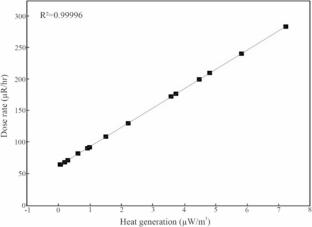
This study investigates the potential of thermal remote sensing for delineating radioactive mineral deposits by examining the relationship between land surface temperature and the presence of these minerals. The underlying hypothesis is that radioactive decay, while typically generating heat, can contribute to detectable thermal anomalies in areas with significant concentrations of radioactive minerals. Utilizing Landsat 8 Operational Land Imager, Land Surface Temperature (LST) patterns are analysed in the coastal region, Podampata, Odisha, eastern coast of India and compared with occurrences of radioactive minerals. The Land Surface Temperature in the study area ranges from 19.4 °C to 28.34 °C. Preliminary findings indicate a positive correlation between LST and the presence of radioactive minerals such as monazite and zircon, suggesting that areas with higher LST represent potential targets for mineral exploration. However, the contribution of radioactive decay heat to the observed LST anomalies needs further investigation and validation through ground-based measurements of radioactivity, Thorium (Th), Uranium (U) and Rare Earth Element (REE) enrichment and detailed thermal modeling. The dose rate ranges from 65 to 240 µR/h, with the highest concentrations of thorium and uranium recorded at 39.61 ppm and 16.28 ppm, respectively. The presence of radioactive heavy minerals such as monazite and zircon and other heavy minerals such as ilmenite and rutile are confirmed from this study. Enrichment of light REE compared to heavy REE along with absorption dips around 1 μm, indicates the presence of Sm3+, commonly associated with monazite. Finally, integration of results from remotely sensed data and field data was performed to obtain a comprehensive solution for delineation of regions enriched with radioactive minerals. This research highlights the potential of thermal remote sensing as a preliminary tool for the identification of regions suitable for the exploration of radioactive minerals.
期刊介绍:
Environmental Earth Sciences is an international multidisciplinary journal concerned with all aspects of interaction between humans, natural resources, ecosystems, special climates or unique geographic zones, and the earth:
Water and soil contamination caused by waste management and disposal practices
Environmental problems associated with transportation by land, air, or water
Geological processes that may impact biosystems or humans
Man-made or naturally occurring geological or hydrological hazards
Environmental problems associated with the recovery of materials from the earth
Environmental problems caused by extraction of minerals, coal, and ores, as well as oil and gas, water and alternative energy sources
Environmental impacts of exploration and recultivation – Environmental impacts of hazardous materials
Management of environmental data and information in data banks and information systems
Dissemination of knowledge on techniques, methods, approaches and experiences to improve and remediate the environment
In pursuit of these topics, the geoscientific disciplines are invited to contribute their knowledge and experience. Major disciplines include: hydrogeology, hydrochemistry, geochemistry, geophysics, engineering geology, remediation science, natural resources management, environmental climatology and biota, environmental geography, soil science and geomicrobiology.

 求助内容:
求助内容: 应助结果提醒方式:


