{"title":"过去的观测和未来的预测表明,喜马拉雅中部的森林扩张和冰川退缩","authors":"Kishor Prasad Bhatta , Om Mishra , Dinesh Prasad Joshi , Bimal Kumar Yadav , Anisha Aryal , Santosh Ayer , Dirk Hölscher","doi":"10.1016/j.envc.2025.101332","DOIUrl":null,"url":null,"abstract":"<div><div>Land use and land cover (LULC) changes, driven by climate variability and human activity, are increasingly threatening the ecological stability of the Himalaya, yet their long-term dynamics remain poorly understood. We address this gap by analyzing past LULC transitions and projecting future changes in the Annapurna Conservation Area from 2000 to 2050. The study area covers 7629 km<sup>2</sup>, considerable elevational variation (800 to >8000 m), and variable precipitation regimes (300 to 3500 mm yr<sup>-1</sup>). We evaluated LULC changes over two decades (2000 - 2020) based on Landsat data and simulate future patterns for 2030 and 2050 using the Cellular Automata – Artificial Neural Networks (CA–ANN) model, integrating spatial drivers and climate data. For the year 2000, a maximum likelihood supervised classification indicated that forest covered 10%, settlement 2%, barren land 65%, snow/glacier 15%, cropland 6%, and waterbody 2% of the area. In the following two decades, forest first declined (-1.2%) and then strongly increased (+3%), settlement area doubled, and cropland was lost. Snow/glacier cover (-1.7%) and waterbody (-2%) declined significantly, while barren land expanded. Under both Shared Socioeconomic Pathways (SSP245 and SSP585), projections suggest continued forest (+4.2 to +4.3%) and settlement (+1.5% to +1.7%) increase and ongoing declines in snow/glacier (-4.7 to -4.9%), waterbody (-0.4%), and cropland (-0.6 to -0.7%) by 2050. These findings highlight the strong human and climate-driven transformations in the region, underscoring the urgency of actions towards climate protection and sustainable resource stewardship for ecological stability in the Himalaya.</div></div>","PeriodicalId":34794,"journal":{"name":"Environmental Challenges","volume":"21 ","pages":"Article 101332"},"PeriodicalIF":0.0000,"publicationDate":"2025-09-30","publicationTypes":"Journal Article","fieldsOfStudy":null,"isOpenAccess":false,"openAccessPdf":"","citationCount":"0","resultStr":"{\"title\":\"Forest expansion and glacial retreat in the Central Himalaya indicated by past observations and future projections\",\"authors\":\"Kishor Prasad Bhatta , Om Mishra , Dinesh Prasad Joshi , Bimal Kumar Yadav , Anisha Aryal , Santosh Ayer , Dirk Hölscher\",\"doi\":\"10.1016/j.envc.2025.101332\",\"DOIUrl\":null,\"url\":null,\"abstract\":\"<div><div>Land use and land cover (LULC) changes, driven by climate variability and human activity, are increasingly threatening the ecological stability of the Himalaya, yet their long-term dynamics remain poorly understood. We address this gap by analyzing past LULC transitions and projecting future changes in the Annapurna Conservation Area from 2000 to 2050. The study area covers 7629 km<sup>2</sup>, considerable elevational variation (800 to >8000 m), and variable precipitation regimes (300 to 3500 mm yr<sup>-1</sup>). We evaluated LULC changes over two decades (2000 - 2020) based on Landsat data and simulate future patterns for 2030 and 2050 using the Cellular Automata – Artificial Neural Networks (CA–ANN) model, integrating spatial drivers and climate data. For the year 2000, a maximum likelihood supervised classification indicated that forest covered 10%, settlement 2%, barren land 65%, snow/glacier 15%, cropland 6%, and waterbody 2% of the area. In the following two decades, forest first declined (-1.2%) and then strongly increased (+3%), settlement area doubled, and cropland was lost. Snow/glacier cover (-1.7%) and waterbody (-2%) declined significantly, while barren land expanded. Under both Shared Socioeconomic Pathways (SSP245 and SSP585), projections suggest continued forest (+4.2 to +4.3%) and settlement (+1.5% to +1.7%) increase and ongoing declines in snow/glacier (-4.7 to -4.9%), waterbody (-0.4%), and cropland (-0.6 to -0.7%) by 2050. These findings highlight the strong human and climate-driven transformations in the region, underscoring the urgency of actions towards climate protection and sustainable resource stewardship for ecological stability in the Himalaya.</div></div>\",\"PeriodicalId\":34794,\"journal\":{\"name\":\"Environmental Challenges\",\"volume\":\"21 \",\"pages\":\"Article 101332\"},\"PeriodicalIF\":0.0000,\"publicationDate\":\"2025-09-30\",\"publicationTypes\":\"Journal Article\",\"fieldsOfStudy\":null,\"isOpenAccess\":false,\"openAccessPdf\":\"\",\"citationCount\":\"0\",\"resultStr\":null,\"platform\":\"Semanticscholar\",\"paperid\":null,\"PeriodicalName\":\"Environmental Challenges\",\"FirstCategoryId\":\"1085\",\"ListUrlMain\":\"https://www.sciencedirect.com/science/article/pii/S2667010025002513\",\"RegionNum\":0,\"RegionCategory\":null,\"ArticlePicture\":[],\"TitleCN\":null,\"AbstractTextCN\":null,\"PMCID\":null,\"EPubDate\":\"\",\"PubModel\":\"\",\"JCR\":\"Q2\",\"JCRName\":\"Environmental Science\",\"Score\":null,\"Total\":0}","platform":"Semanticscholar","paperid":null,"PeriodicalName":"Environmental Challenges","FirstCategoryId":"1085","ListUrlMain":"https://www.sciencedirect.com/science/article/pii/S2667010025002513","RegionNum":0,"RegionCategory":null,"ArticlePicture":[],"TitleCN":null,"AbstractTextCN":null,"PMCID":null,"EPubDate":"","PubModel":"","JCR":"Q2","JCRName":"Environmental Science","Score":null,"Total":0}
Forest expansion and glacial retreat in the Central Himalaya indicated by past observations and future projections
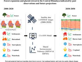
Land use and land cover (LULC) changes, driven by climate variability and human activity, are increasingly threatening the ecological stability of the Himalaya, yet their long-term dynamics remain poorly understood. We address this gap by analyzing past LULC transitions and projecting future changes in the Annapurna Conservation Area from 2000 to 2050. The study area covers 7629 km2, considerable elevational variation (800 to >8000 m), and variable precipitation regimes (300 to 3500 mm yr-1). We evaluated LULC changes over two decades (2000 - 2020) based on Landsat data and simulate future patterns for 2030 and 2050 using the Cellular Automata – Artificial Neural Networks (CA–ANN) model, integrating spatial drivers and climate data. For the year 2000, a maximum likelihood supervised classification indicated that forest covered 10%, settlement 2%, barren land 65%, snow/glacier 15%, cropland 6%, and waterbody 2% of the area. In the following two decades, forest first declined (-1.2%) and then strongly increased (+3%), settlement area doubled, and cropland was lost. Snow/glacier cover (-1.7%) and waterbody (-2%) declined significantly, while barren land expanded. Under both Shared Socioeconomic Pathways (SSP245 and SSP585), projections suggest continued forest (+4.2 to +4.3%) and settlement (+1.5% to +1.7%) increase and ongoing declines in snow/glacier (-4.7 to -4.9%), waterbody (-0.4%), and cropland (-0.6 to -0.7%) by 2050. These findings highlight the strong human and climate-driven transformations in the region, underscoring the urgency of actions towards climate protection and sustainable resource stewardship for ecological stability in the Himalaya.