金沙江四大梯级水电站库区活动滑坡对比研究
IF 3.1
2区 地球科学
Q2 GEOGRAPHY, PHYSICAL
引用次数: 0
摘要
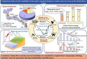
大型水库蓄水对边坡稳定性的影响在扩展的时空维度上尤为严重,对水电基础设施和下游社区构成威胁。虽然这是一个备受关注的话题,但在水库诱发滑坡的特征、变形规律和机理方面仍存在许多争议。因此,本文首次对4座世界级巨型梯级水电站水库诱发滑坡进行了系统比较。通过综合遥感技术、干涉合成孔径雷达(InSAR)和地质统计分析方法,调查了中国金沙江沿线向家坝、溪洛渡、白鹤滩和武东德四个梯级水库的283次滑坡(198次)。结果表明:(1)水库诱发滑坡以大型堆积性滑坡为主。水库诱发滑坡具有相似的空间分布特征,以低起伏地形和坝旁缓坡为主,集中在7个区。(2)水库诱发滑坡在高差、坡度、地层岩性及与构造的关系等方面存在显著差异。它们在高差和坡度特征上的发展顺序为XJB <; XLD < WDD <; BHT。不同储层的地质控制模式不同:XJB以侏罗系砂岩-泥岩互层岩性为主;XLD和BHT分别受奥陶系-志留系-寒武系和奥陶系-志留系-元古界岩性组合控制,处于较强的岩性-构造耦合作用下;WDD受侏罗纪-元古代岩性和构造的影响,具有构造-岩性弱耦合的特征。(3)水库运行方式是影响水库诱发滑坡变形时间、变形程度和变形机制的最重要因素。在第一期蓄水阶段变形最剧烈,水位波动越大,诱导变形程度越大。以水动力压力型滑坡为优势类型,在弧形滑动面上发育,随下沉而减小;浮力减重型滑坡随下沉呈“先增后减”的趋势,主要集中在椅形滑移面。界定了水库诱发滑坡的异同特征,记录了有价值的资料,为水库诱发滑坡的防治提供了明确的对象。本文章由计算机程序翻译,如有差异,请以英文原文为准。
Comparison study of active landslides in four giant cascade hydropower station reservoir areas on the Jinsha River, China
Large reservoir impoundment poses exceptionally severe impacts on slope stability across extended spatial and temporal dimensions, threatening hydropower infrastructure and downstream communities. Although this is a topic of great concern, there are still many disputes in the characteristics, deformation laws and mechanisms of reservoir-induced landslides. Therefore, this paper systematically compares reservoir-induced landslides in the four world-class giant cascade hydropower stations for the first time. The investigation is carried out by integrating remote sensing techniques, Interferometric Synthetic Aperture Radar (InSAR), and geostatistical analysis methods, and examines 283 landslides (198 reservoir-induced) across the four cascade reservoirs along China's Jinsha River, specifically Xiangjiaba (XJB), Xiluodu (XLD), Baihetan (BHT), and Wudongde (WDD). The results showed: (1) The reservoir-induced landslides are dominated by large-scale accumulation landslides. And reservoir-induced landslides have similar spatial distribution characteristics, mainly in low-relief topography and gentle slopes near dams, concentrating in seven zones. (2) There are significant differences in elevation difference, slope, stratigraphic lithology and relationship with tectonics of reservoir-induced landslides. Their development in in the elevation difference and slope characteristics is ranked as XJB < XLD < WDD < BHT. Geological control patterns vary among reservoirs: XJB is dominated by Jurassic sandstone-mudstone interbedded lithology; XLD and BHT are under strong lithology-structure coupling, controlled by Ordovician-Silurian-Cambrian and Ordovician-Silurian-Proterozoic lithological assemblages, respectively; and WDD, influenced by Jurassic-Proterozoic lithology and structures, is characterized by weak tectono-lithological coupling. (3) Reservoir operation mode is the most important factor affecting the deformation time, degree and mechanism of reservoir-induced landslides. The most intense deformation occurs during the first impoundment stage, and greater water-level fluctuations increase the degree of induced deformation. Hydrodynamic pressure-type landslides, the dominant type, develop on arc slip surfaces and decrease with submergence; buoyancy weight loss-type landslides show a “first increasing then decreasing” trend with submergence, concentrating on chair-shaped slip surfaces. This paper defines the similar and different characteristics of landslide induced by reservoirs, records valuable data, and provides a clear object for the prevention and control of reservoir-induced landslides.
求助全文
通过发布文献求助,成功后即可免费获取论文全文。
去求助
来源期刊

Geomorphology
地学-地球科学综合
CiteScore
8.00
自引率
10.30%
发文量
309
审稿时长
3.4 months
期刊介绍:
Our journal''s scope includes geomorphic themes of: tectonics and regional structure; glacial processes and landforms; fluvial sequences, Quaternary environmental change and dating; fluvial processes and landforms; mass movement, slopes and periglacial processes; hillslopes and soil erosion; weathering, karst and soils; aeolian processes and landforms, coastal dunes and arid environments; coastal and marine processes, estuaries and lakes; modelling, theoretical and quantitative geomorphology; DEM, GIS and remote sensing methods and applications; hazards, applied and planetary geomorphology; and volcanics.
 求助内容:
求助内容: 应助结果提醒方式:


