洪水影响分析的城市规模数字孪生框架:整合城市基础设施和实时数据分析

IF 6.9 2区 工程技术 Q1 ENVIRONMENTAL SCIENCES
Sümeyye Kaynak , Baran Kaynak , Omer Mermer , Ibrahim Demir
{"title":"洪水影响分析的城市规模数字孪生框架:整合城市基础设施和实时数据分析","authors":"Sümeyye Kaynak ,&nbsp;Baran Kaynak ,&nbsp;Omer Mermer ,&nbsp;Ibrahim Demir","doi":"10.1016/j.uclim.2025.102640","DOIUrl":null,"url":null,"abstract":"<div><div>Urban areas are increasingly vulnerable to flooding due to climate change and rapid urbanization. Traditional mapping and decision-support tools lack the capability to integrate real-time data or analyze cascading disruptions across interconnected urban systems. Digital twins offer a promising solution by enabling real-time monitoring, simulation, and optimization of urban environments. This study presents a comprehensive city-scale digital twin framework that integrates flood forecasting, transportation networks, and critical infrastructure systems into a unified, real-time cyberinfrastructure. By leveraging data from sensors, hydrological models, and geographic information systems (GIS), the framework enables interactive, three-dimensional simulations to assess flood impacts and their cascading effects on urban mobility and infrastructure. Using Waterloo, Iowa, as a case study, we demonstrate the framework's ability to simulate flood scenarios, assess transportation disruptions, and generate actionable insights for disaster preparedness. The results highlight the framework's potential to enhance urban resilience by providing a holistic understanding of interdependent urban systems, supporting data-driven decision-making, and advancing flood risk management strategies.</div></div>","PeriodicalId":48626,"journal":{"name":"Urban Climate","volume":"64 ","pages":"Article 102640"},"PeriodicalIF":6.9000,"publicationDate":"2025-10-04","publicationTypes":"Journal Article","fieldsOfStudy":null,"isOpenAccess":false,"openAccessPdf":"","citationCount":"0","resultStr":"{\"title\":\"City-scale digital twin framework for flood impact analysis: Integrating urban infrastructure and real-time data analytics\",\"authors\":\"Sümeyye Kaynak ,&nbsp;Baran Kaynak ,&nbsp;Omer Mermer ,&nbsp;Ibrahim Demir\",\"doi\":\"10.1016/j.uclim.2025.102640\",\"DOIUrl\":null,\"url\":null,\"abstract\":\"<div><div>Urban areas are increasingly vulnerable to flooding due to climate change and rapid urbanization. Traditional mapping and decision-support tools lack the capability to integrate real-time data or analyze cascading disruptions across interconnected urban systems. Digital twins offer a promising solution by enabling real-time monitoring, simulation, and optimization of urban environments. This study presents a comprehensive city-scale digital twin framework that integrates flood forecasting, transportation networks, and critical infrastructure systems into a unified, real-time cyberinfrastructure. By leveraging data from sensors, hydrological models, and geographic information systems (GIS), the framework enables interactive, three-dimensional simulations to assess flood impacts and their cascading effects on urban mobility and infrastructure. Using Waterloo, Iowa, as a case study, we demonstrate the framework's ability to simulate flood scenarios, assess transportation disruptions, and generate actionable insights for disaster preparedness. The results highlight the framework's potential to enhance urban resilience by providing a holistic understanding of interdependent urban systems, supporting data-driven decision-making, and advancing flood risk management strategies.</div></div>\",\"PeriodicalId\":48626,\"journal\":{\"name\":\"Urban Climate\",\"volume\":\"64 \",\"pages\":\"Article 102640\"},\"PeriodicalIF\":6.9000,\"publicationDate\":\"2025-10-04\",\"publicationTypes\":\"Journal Article\",\"fieldsOfStudy\":null,\"isOpenAccess\":false,\"openAccessPdf\":\"\",\"citationCount\":\"0\",\"resultStr\":null,\"platform\":\"Semanticscholar\",\"paperid\":null,\"PeriodicalName\":\"Urban Climate\",\"FirstCategoryId\":\"5\",\"ListUrlMain\":\"https://www.sciencedirect.com/science/article/pii/S2212095525003566\",\"RegionNum\":2,\"RegionCategory\":\"工程技术\",\"ArticlePicture\":[],\"TitleCN\":null,\"AbstractTextCN\":null,\"PMCID\":null,\"EPubDate\":\"\",\"PubModel\":\"\",\"JCR\":\"Q1\",\"JCRName\":\"ENVIRONMENTAL SCIENCES\",\"Score\":null,\"Total\":0}","platform":"Semanticscholar","paperid":null,"PeriodicalName":"Urban Climate","FirstCategoryId":"5","ListUrlMain":"https://www.sciencedirect.com/science/article/pii/S2212095525003566","RegionNum":2,"RegionCategory":"工程技术","ArticlePicture":[],"TitleCN":null,"AbstractTextCN":null,"PMCID":null,"EPubDate":"","PubModel":"","JCR":"Q1","JCRName":"ENVIRONMENTAL SCIENCES","Score":null,"Total":0}
引用次数: 0

摘要

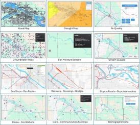
由于气候变化和快速城市化,城市地区越来越容易受到洪水的影响。传统的制图和决策支持工具缺乏整合实时数据或分析互联城市系统间级联中断的能力。数字孪生通过实现城市环境的实时监控、模拟和优化,提供了一个很有前途的解决方案。本研究提出了一个综合的城市规模数字孪生框架,将洪水预报、交通网络和关键基础设施系统集成到一个统一的实时网络基础设施中。通过利用来自传感器、水文模型和地理信息系统(GIS)的数据,该框架实现了交互式三维模拟,以评估洪水影响及其对城市交通和基础设施的级联效应。以爱荷华州滑铁卢市为例,我们展示了该框架在模拟洪水情景、评估交通中断以及为备灾提供可操作见解方面的能力。研究结果强调了该框架的潜力,即通过全面了解相互依存的城市系统、支持数据驱动的决策和推进洪水风险管理战略,增强城市抵御能力。
本文章由计算机程序翻译,如有差异,请以英文原文为准。

City-scale digital twin framework for flood impact analysis: Integrating urban infrastructure and real-time data analytics

City-scale digital twin framework for flood impact analysis: Integrating urban infrastructure and real-time data analytics
Urban areas are increasingly vulnerable to flooding due to climate change and rapid urbanization. Traditional mapping and decision-support tools lack the capability to integrate real-time data or analyze cascading disruptions across interconnected urban systems. Digital twins offer a promising solution by enabling real-time monitoring, simulation, and optimization of urban environments. This study presents a comprehensive city-scale digital twin framework that integrates flood forecasting, transportation networks, and critical infrastructure systems into a unified, real-time cyberinfrastructure. By leveraging data from sensors, hydrological models, and geographic information systems (GIS), the framework enables interactive, three-dimensional simulations to assess flood impacts and their cascading effects on urban mobility and infrastructure. Using Waterloo, Iowa, as a case study, we demonstrate the framework's ability to simulate flood scenarios, assess transportation disruptions, and generate actionable insights for disaster preparedness. The results highlight the framework's potential to enhance urban resilience by providing a holistic understanding of interdependent urban systems, supporting data-driven decision-making, and advancing flood risk management strategies.
求助全文
通过发布文献求助,成功后即可免费获取论文全文。 去求助
来源期刊
Urban Climate
Urban Climate Social Sciences-Urban Studies
CiteScore
9.70
自引率
9.40%
发文量
286
期刊介绍: Urban Climate serves the scientific and decision making communities with the publication of research on theory, science and applications relevant to understanding urban climatic conditions and change in relation to their geography and to demographic, socioeconomic, institutional, technological and environmental dynamics and global change. Targeted towards both disciplinary and interdisciplinary audiences, this journal publishes original research papers, comprehensive review articles, book reviews, and short communications on topics including, but not limited to, the following: Urban meteorology and climate[...] Urban environmental pollution[...] Adaptation to global change[...] Urban economic and social issues[...] Research Approaches[...]
×
引用
GB/T 7714-2015
复制
MLA
复制
APA
复制
导出至
BibTeX EndNote RefMan NoteFirst NoteExpress
×
提示
您的信息不完整,为了账户安全,请先补充。
现在去补充
×
提示
您因"违规操作"
具体请查看互助需知
我知道了
×
提示
确定
请完成安全验证×
copy
已复制链接
快去分享给好友吧!
我知道了
右上角分享
点击右上角分享
0
联系我们:info@booksci.cn Book学术提供免费学术资源搜索服务,方便国内外学者检索中英文文献。致力于提供最便捷和优质的服务体验。 Copyright © 2023 布克学术 All rights reserved.
京ICP备2023020795号-1
ghs 京公网安备 11010802042870号
Book学术文献互助
Book学术文献互助群
群 号:604180095
Book学术官方微信