{"title":"一种最先进的方法来评估英国城市洪水恢复能力的相对多维脆弱性","authors":"Arthur C. Woods , Vijaya Gupta , Luiza C. Campos","doi":"10.1016/j.ijdrr.2025.105827","DOIUrl":null,"url":null,"abstract":"<div><div>This paper aims to quantify and integrate the Flood Exposure Index (FEI) and the Flood Sensitivity Index (FSI) to develop the Flood Multi-dimensional Vulnerability Index (FMVI), focusing on Kingston upon Hull, the UK's second most flood-vulnerable city. The research applies Geographic Information Systems (GIS) to map flood risk parameters spatially and employs the Analytical Hierarchical Process (AHP) to incorporate expert judgement more useful for in weighting the vulnerability parameters. A novel concept of Impact Percentiles is introduced using the Index of Multiple Deprivation (IMD), comparing localised deprivation scores against national averages and maxima to quantify relative multi-dimensional vulnerabilities. Assessing relative multi-dimensional vulnerability is superior because it contextualises vulnerability by enabling comparisons across regions or populations, making it more useful for prioritisation, policy decisions, and resource allocation. The analysis reveals acute deprivation across six Lower Layer Super Output Areas (LSOAs) in Kingston upon Hull and estimates relative disadvantage. Critical data-driven insight is provided into the intersection of physical flood exposure and socio-economic sensitivity. This data-driven research approach emphasises the ease and significance of integrating geospatial and socio-economic insights from a range of Impact Percentiles to prioritise high deprivation areas for policy interventions, enabling nuanced flood risk assessments, mitigation, and adaptation strategies.</div></div>","PeriodicalId":13915,"journal":{"name":"International journal of disaster risk reduction","volume":"130 ","pages":"Article 105827"},"PeriodicalIF":4.5000,"publicationDate":"2025-09-18","publicationTypes":"Journal Article","fieldsOfStudy":null,"isOpenAccess":false,"openAccessPdf":"","citationCount":"0","resultStr":"{\"title\":\"A state-of-the-art approach to assessing relative multi-dimensional vulnerabilities for urban flood resilience in the UK\",\"authors\":\"Arthur C. Woods , Vijaya Gupta , Luiza C. Campos\",\"doi\":\"10.1016/j.ijdrr.2025.105827\",\"DOIUrl\":null,\"url\":null,\"abstract\":\"<div><div>This paper aims to quantify and integrate the Flood Exposure Index (FEI) and the Flood Sensitivity Index (FSI) to develop the Flood Multi-dimensional Vulnerability Index (FMVI), focusing on Kingston upon Hull, the UK's second most flood-vulnerable city. The research applies Geographic Information Systems (GIS) to map flood risk parameters spatially and employs the Analytical Hierarchical Process (AHP) to incorporate expert judgement more useful for in weighting the vulnerability parameters. A novel concept of Impact Percentiles is introduced using the Index of Multiple Deprivation (IMD), comparing localised deprivation scores against national averages and maxima to quantify relative multi-dimensional vulnerabilities. Assessing relative multi-dimensional vulnerability is superior because it contextualises vulnerability by enabling comparisons across regions or populations, making it more useful for prioritisation, policy decisions, and resource allocation. The analysis reveals acute deprivation across six Lower Layer Super Output Areas (LSOAs) in Kingston upon Hull and estimates relative disadvantage. Critical data-driven insight is provided into the intersection of physical flood exposure and socio-economic sensitivity. This data-driven research approach emphasises the ease and significance of integrating geospatial and socio-economic insights from a range of Impact Percentiles to prioritise high deprivation areas for policy interventions, enabling nuanced flood risk assessments, mitigation, and adaptation strategies.</div></div>\",\"PeriodicalId\":13915,\"journal\":{\"name\":\"International journal of disaster risk reduction\",\"volume\":\"130 \",\"pages\":\"Article 105827\"},\"PeriodicalIF\":4.5000,\"publicationDate\":\"2025-09-18\",\"publicationTypes\":\"Journal Article\",\"fieldsOfStudy\":null,\"isOpenAccess\":false,\"openAccessPdf\":\"\",\"citationCount\":\"0\",\"resultStr\":null,\"platform\":\"Semanticscholar\",\"paperid\":null,\"PeriodicalName\":\"International journal of disaster risk reduction\",\"FirstCategoryId\":\"89\",\"ListUrlMain\":\"https://www.sciencedirect.com/science/article/pii/S221242092500651X\",\"RegionNum\":1,\"RegionCategory\":\"地球科学\",\"ArticlePicture\":[],\"TitleCN\":null,\"AbstractTextCN\":null,\"PMCID\":null,\"EPubDate\":\"\",\"PubModel\":\"\",\"JCR\":\"Q1\",\"JCRName\":\"GEOSCIENCES, MULTIDISCIPLINARY\",\"Score\":null,\"Total\":0}","platform":"Semanticscholar","paperid":null,"PeriodicalName":"International journal of disaster risk reduction","FirstCategoryId":"89","ListUrlMain":"https://www.sciencedirect.com/science/article/pii/S221242092500651X","RegionNum":1,"RegionCategory":"地球科学","ArticlePicture":[],"TitleCN":null,"AbstractTextCN":null,"PMCID":null,"EPubDate":"","PubModel":"","JCR":"Q1","JCRName":"GEOSCIENCES, MULTIDISCIPLINARY","Score":null,"Total":0}
引用次数: 0
摘要
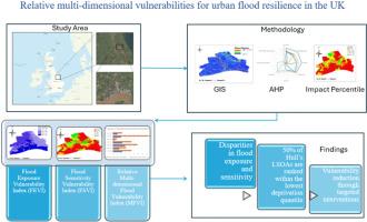
本文旨在将洪水暴露指数(FEI)和洪水敏感性指数(FSI)进行量化和整合,形成洪水多维脆弱性指数(FMVI),并以英国第二大洪水易损性城市Kingston upon Hull为研究对象。本研究利用地理信息系统(GIS)对洪水风险参数进行空间映射,并采用层次分析法(AHP)将专家判断融入到脆弱性参数的权重中。使用多重剥夺指数(IMD)引入了影响百分位数的新概念,将局部剥夺分数与全国平均水平和最大值进行比较,以量化相对多维脆弱性。评估相对的多维脆弱性是优越的,因为它可以通过跨区域或人口的比较来将脆弱性置于背景中,使其对优先次序、政策决策和资源分配更有用。分析显示,在赫尔的金斯顿,六个底层超级输出区(lsoa)存在严重的贫困,并估计了相对劣势。关键数据驱动的洞察力提供了物理洪水暴露和社会经济敏感性的交集。这种数据驱动的研究方法强调了从一系列影响百分位数中整合地理空间和社会经济见解的便利性和重要性,以优先考虑政策干预的高度贫困地区,从而实现细致入微的洪水风险评估、缓解和适应战略。
A state-of-the-art approach to assessing relative multi-dimensional vulnerabilities for urban flood resilience in the UK
This paper aims to quantify and integrate the Flood Exposure Index (FEI) and the Flood Sensitivity Index (FSI) to develop the Flood Multi-dimensional Vulnerability Index (FMVI), focusing on Kingston upon Hull, the UK's second most flood-vulnerable city. The research applies Geographic Information Systems (GIS) to map flood risk parameters spatially and employs the Analytical Hierarchical Process (AHP) to incorporate expert judgement more useful for in weighting the vulnerability parameters. A novel concept of Impact Percentiles is introduced using the Index of Multiple Deprivation (IMD), comparing localised deprivation scores against national averages and maxima to quantify relative multi-dimensional vulnerabilities. Assessing relative multi-dimensional vulnerability is superior because it contextualises vulnerability by enabling comparisons across regions or populations, making it more useful for prioritisation, policy decisions, and resource allocation. The analysis reveals acute deprivation across six Lower Layer Super Output Areas (LSOAs) in Kingston upon Hull and estimates relative disadvantage. Critical data-driven insight is provided into the intersection of physical flood exposure and socio-economic sensitivity. This data-driven research approach emphasises the ease and significance of integrating geospatial and socio-economic insights from a range of Impact Percentiles to prioritise high deprivation areas for policy interventions, enabling nuanced flood risk assessments, mitigation, and adaptation strategies.
期刊介绍:
The International Journal of Disaster Risk Reduction (IJDRR) is the journal for researchers, policymakers and practitioners across diverse disciplines: earth sciences and their implications; environmental sciences; engineering; urban studies; geography; and the social sciences. IJDRR publishes fundamental and applied research, critical reviews, policy papers and case studies with a particular focus on multi-disciplinary research that aims to reduce the impact of natural, technological, social and intentional disasters. IJDRR stimulates exchange of ideas and knowledge transfer on disaster research, mitigation, adaptation, prevention and risk reduction at all geographical scales: local, national and international.
Key topics:-
-multifaceted disaster and cascading disasters
-the development of disaster risk reduction strategies and techniques
-discussion and development of effective warning and educational systems for risk management at all levels
-disasters associated with climate change
-vulnerability analysis and vulnerability trends
-emerging risks
-resilience against disasters.
The journal particularly encourages papers that approach risk from a multi-disciplinary perspective.