Dorsa Rahparast , Seied Mehdy Hashemy Shahdany , Abbas Roozbahani
{"title":"灌溉水运行绩效的wef -环境Nexus指标空间聚类:特征驱动方法","authors":"Dorsa Rahparast , Seied Mehdy Hashemy Shahdany , Abbas Roozbahani","doi":"10.1016/j.eiar.2025.108205","DOIUrl":null,"url":null,"abstract":"<div><div>The technical assessment of surface water distribution among water-right holders within an irrigation district under conditions of water supply stress did not yield a comprehensive operational appraisal. The Water–Energy–Food (WEF)–Environment nexus-assessment approach offers a holistic and pragmatic evaluation by incorporating technical assessment alongside considerations of energy and environmental trade-offs. This study presents an innovative clustering-based WEF-Environment spatial assessment methodology that combines hydraulic simulation and data-driven feature selection. An integrated hydraulic-operation model was developed to simulate daily operations under stressed scenarios. From this, nine key indicators were generated—such as Surface Water Delivery (SWD), Energy Consumption (EC), Carbon Emissions (CE), and Energy Productivity (EP). To enhance clustering accuracy, a cross-validated feature selection approach was applied, ranking indicators according to their contribution to clustering quality. The proposed methodology is implemented in Nekouabad Irrigation District, Iran, and the Nexus-based clustering and GIS-based spatial mapping were conducted using the selected features. Cross-validation across operational scenarios confirms the robustness of the feature-driven approach. SWD, CE, and Surface Water-Based Cultivated Area (SWCR) are key indicators that identify performance patterns. Under high stress, low-performing areas grew to cover over 90 % of the district. Environmental costs rose accordingly; in some zones, SWD dropped below 35 %, while carbon emissions exceeded 100,000 kg CO₂, indicating unsustainable operational trade-offs. Only a small portion of the district maintained balanced performance across delivery, efficiency, and emissions metrics. The study demonstrates that integrating feature selection with spatial clustering can identify priority areas for intervention, improve nexus assessments, and provide actionable insights for water managers.</div></div>","PeriodicalId":309,"journal":{"name":"Environmental Impact Assessment Review","volume":"117 ","pages":"Article 108205"},"PeriodicalIF":11.2000,"publicationDate":"2025-10-03","publicationTypes":"Journal Article","fieldsOfStudy":null,"isOpenAccess":false,"openAccessPdf":"","citationCount":"0","resultStr":"{\"title\":\"Spatial clustering of WEF-environment Nexus indicators for irrigation water operational performance: A feature-driven approach\",\"authors\":\"Dorsa Rahparast , Seied Mehdy Hashemy Shahdany , Abbas Roozbahani\",\"doi\":\"10.1016/j.eiar.2025.108205\",\"DOIUrl\":null,\"url\":null,\"abstract\":\"<div><div>The technical assessment of surface water distribution among water-right holders within an irrigation district under conditions of water supply stress did not yield a comprehensive operational appraisal. The Water–Energy–Food (WEF)–Environment nexus-assessment approach offers a holistic and pragmatic evaluation by incorporating technical assessment alongside considerations of energy and environmental trade-offs. This study presents an innovative clustering-based WEF-Environment spatial assessment methodology that combines hydraulic simulation and data-driven feature selection. An integrated hydraulic-operation model was developed to simulate daily operations under stressed scenarios. From this, nine key indicators were generated—such as Surface Water Delivery (SWD), Energy Consumption (EC), Carbon Emissions (CE), and Energy Productivity (EP). To enhance clustering accuracy, a cross-validated feature selection approach was applied, ranking indicators according to their contribution to clustering quality. The proposed methodology is implemented in Nekouabad Irrigation District, Iran, and the Nexus-based clustering and GIS-based spatial mapping were conducted using the selected features. Cross-validation across operational scenarios confirms the robustness of the feature-driven approach. SWD, CE, and Surface Water-Based Cultivated Area (SWCR) are key indicators that identify performance patterns. Under high stress, low-performing areas grew to cover over 90 % of the district. Environmental costs rose accordingly; in some zones, SWD dropped below 35 %, while carbon emissions exceeded 100,000 kg CO₂, indicating unsustainable operational trade-offs. Only a small portion of the district maintained balanced performance across delivery, efficiency, and emissions metrics. The study demonstrates that integrating feature selection with spatial clustering can identify priority areas for intervention, improve nexus assessments, and provide actionable insights for water managers.</div></div>\",\"PeriodicalId\":309,\"journal\":{\"name\":\"Environmental Impact Assessment Review\",\"volume\":\"117 \",\"pages\":\"Article 108205\"},\"PeriodicalIF\":11.2000,\"publicationDate\":\"2025-10-03\",\"publicationTypes\":\"Journal Article\",\"fieldsOfStudy\":null,\"isOpenAccess\":false,\"openAccessPdf\":\"\",\"citationCount\":\"0\",\"resultStr\":null,\"platform\":\"Semanticscholar\",\"paperid\":null,\"PeriodicalName\":\"Environmental Impact Assessment Review\",\"FirstCategoryId\":\"90\",\"ListUrlMain\":\"https://www.sciencedirect.com/science/article/pii/S0195925525004020\",\"RegionNum\":1,\"RegionCategory\":\"社会学\",\"ArticlePicture\":[],\"TitleCN\":null,\"AbstractTextCN\":null,\"PMCID\":null,\"EPubDate\":\"\",\"PubModel\":\"\",\"JCR\":\"Q1\",\"JCRName\":\"ENVIRONMENTAL STUDIES\",\"Score\":null,\"Total\":0}","platform":"Semanticscholar","paperid":null,"PeriodicalName":"Environmental Impact Assessment Review","FirstCategoryId":"90","ListUrlMain":"https://www.sciencedirect.com/science/article/pii/S0195925525004020","RegionNum":1,"RegionCategory":"社会学","ArticlePicture":[],"TitleCN":null,"AbstractTextCN":null,"PMCID":null,"EPubDate":"","PubModel":"","JCR":"Q1","JCRName":"ENVIRONMENTAL STUDIES","Score":null,"Total":0}
引用次数: 0
摘要
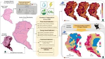
在供水紧张的情况下,对灌区内水权持有者之间地表水分配情况的技术评价并没有产生全面的业务评价。水-能源-粮食-环境关系评估方法通过将技术评估与能源和环境权衡考虑结合起来,提供了全面和务实的评价。本研究提出了一种创新的基于聚类的wef -环境空间评价方法,该方法结合了水力模拟和数据驱动的特征选择。开发了一个综合水力-作业模型,以模拟应力情景下的日常作业。由此产生了9个关键指标,如地表水输送(SWD)、能源消耗(EC)、碳排放(CE)和能源生产率(EP)。为了提高聚类精度,采用了一种交叉验证的特征选择方法,根据指标对聚类质量的贡献对其进行排序。提出的方法在伊朗Nekouabad灌溉区实施,并使用选定的特征进行了基于nexus的聚类和基于gis的空间制图。跨操作场景的交叉验证确认了功能驱动方法的健壮性。SWD、CE和地表水基耕地面积(SWCR)是识别绩效模式的关键指标。在高度紧张的情况下,表现不佳的地区扩大到该地区90%以上的地区。环境成本相应上升;在一些地区,SWD降至35%以下,而碳排放量超过100,000 kg CO₂,表明不可持续的运营权衡。该地区只有一小部分在交付、效率和排放指标方面保持平衡的绩效。研究表明,将特征选择与空间聚类相结合,可以确定优先干预区域,改善联系评估,并为水资源管理者提供可操作的见解。
Spatial clustering of WEF-environment Nexus indicators for irrigation water operational performance: A feature-driven approach
The technical assessment of surface water distribution among water-right holders within an irrigation district under conditions of water supply stress did not yield a comprehensive operational appraisal. The Water–Energy–Food (WEF)–Environment nexus-assessment approach offers a holistic and pragmatic evaluation by incorporating technical assessment alongside considerations of energy and environmental trade-offs. This study presents an innovative clustering-based WEF-Environment spatial assessment methodology that combines hydraulic simulation and data-driven feature selection. An integrated hydraulic-operation model was developed to simulate daily operations under stressed scenarios. From this, nine key indicators were generated—such as Surface Water Delivery (SWD), Energy Consumption (EC), Carbon Emissions (CE), and Energy Productivity (EP). To enhance clustering accuracy, a cross-validated feature selection approach was applied, ranking indicators according to their contribution to clustering quality. The proposed methodology is implemented in Nekouabad Irrigation District, Iran, and the Nexus-based clustering and GIS-based spatial mapping were conducted using the selected features. Cross-validation across operational scenarios confirms the robustness of the feature-driven approach. SWD, CE, and Surface Water-Based Cultivated Area (SWCR) are key indicators that identify performance patterns. Under high stress, low-performing areas grew to cover over 90 % of the district. Environmental costs rose accordingly; in some zones, SWD dropped below 35 %, while carbon emissions exceeded 100,000 kg CO₂, indicating unsustainable operational trade-offs. Only a small portion of the district maintained balanced performance across delivery, efficiency, and emissions metrics. The study demonstrates that integrating feature selection with spatial clustering can identify priority areas for intervention, improve nexus assessments, and provide actionable insights for water managers.
期刊介绍:
Environmental Impact Assessment Review is an interdisciplinary journal that serves a global audience of practitioners, policymakers, and academics involved in assessing the environmental impact of policies, projects, processes, and products. The journal focuses on innovative theory and practice in environmental impact assessment (EIA). Papers are expected to present innovative ideas, be topical, and coherent. The journal emphasizes concepts, methods, techniques, approaches, and systems related to EIA theory and practice.