基于水位传感器网络的城市下水道系统降雨入渗空间异质性识别:来自可解释深度学习方法的见解。

IF 7.7 2区 环境科学与生态学 Q1 ENVIRONMENTAL SCIENCES
Yue Zheng , Xinyu Chen , Qing Zhang , Yiping Zhang , Yongming Wang , Xiaoli Zou , Yongchao Zhou
{"title":"基于水位传感器网络的城市下水道系统降雨入渗空间异质性识别:来自可解释深度学习方法的见解。","authors":"Yue Zheng ,&nbsp;Xinyu Chen ,&nbsp;Qing Zhang ,&nbsp;Yiping Zhang ,&nbsp;Yongming Wang ,&nbsp;Xiaoli Zou ,&nbsp;Yongchao Zhou","doi":"10.1016/j.envres.2025.122999","DOIUrl":null,"url":null,"abstract":"<div><div>Due to the spatial heterogeneity of rainfall-derived inflow and infiltration (RDII) in urban sewer systems, accurately identifying the subcatchment with the most severe RDII is crucial for the subsequent management of the sewer system. With the increase in monitoring sensors in sewer systems, it is an urgent problem to mine information from the rich water level data to identify subcatchments with severe RDII. Traditional modeling methods either rely on large amounts of data related to water quality and flow, or struggle to capture the topological patterns and complex nonlinear relationships in sewer systems. Thus, this study proposes a severe RDII subcatchment identification method based on the water level sensors and interpretable deep learning algorithm. First, the sewer system is divided into several subcatchments based on the locations of the sensors. Deep learning prediction models for each subcatchment in dry and wet weather are developed using low-cost water level monitoring data. The deep learning models are subsequently analyzed using explainable artificial intelligence (XAI) method to identify RDII severity. After the method was tested in the case study, the developed deep learning models were proven to capture the response relationships between different monitoring sites and external rainfall. Moreover, the results show that the utilization of simple water level sensors, combined with advanced interpretable deep learning algorithms, can effectively identify different degrees of RDII in each subcatchment. This work provides a feasible method for spatial heterogeneity identification for RDII based on low-cost measurements that reduces monitoring and modeling costs, and has the potential for widespread application.</div></div>","PeriodicalId":312,"journal":{"name":"Environmental Research","volume":"286 ","pages":"Article 122999"},"PeriodicalIF":7.7000,"publicationDate":"2025-10-01","publicationTypes":"Journal Article","fieldsOfStudy":null,"isOpenAccess":false,"openAccessPdf":"","citationCount":"0","resultStr":"{\"title\":\"Spatial heterogeneity identification for rainfall-derived inflow and infiltration in urban sewer systems based on water level sensor networks: Insights from an interpretable deep learning method\",\"authors\":\"Yue Zheng ,&nbsp;Xinyu Chen ,&nbsp;Qing Zhang ,&nbsp;Yiping Zhang ,&nbsp;Yongming Wang ,&nbsp;Xiaoli Zou ,&nbsp;Yongchao Zhou\",\"doi\":\"10.1016/j.envres.2025.122999\",\"DOIUrl\":null,\"url\":null,\"abstract\":\"<div><div>Due to the spatial heterogeneity of rainfall-derived inflow and infiltration (RDII) in urban sewer systems, accurately identifying the subcatchment with the most severe RDII is crucial for the subsequent management of the sewer system. With the increase in monitoring sensors in sewer systems, it is an urgent problem to mine information from the rich water level data to identify subcatchments with severe RDII. Traditional modeling methods either rely on large amounts of data related to water quality and flow, or struggle to capture the topological patterns and complex nonlinear relationships in sewer systems. Thus, this study proposes a severe RDII subcatchment identification method based on the water level sensors and interpretable deep learning algorithm. First, the sewer system is divided into several subcatchments based on the locations of the sensors. Deep learning prediction models for each subcatchment in dry and wet weather are developed using low-cost water level monitoring data. The deep learning models are subsequently analyzed using explainable artificial intelligence (XAI) method to identify RDII severity. After the method was tested in the case study, the developed deep learning models were proven to capture the response relationships between different monitoring sites and external rainfall. Moreover, the results show that the utilization of simple water level sensors, combined with advanced interpretable deep learning algorithms, can effectively identify different degrees of RDII in each subcatchment. This work provides a feasible method for spatial heterogeneity identification for RDII based on low-cost measurements that reduces monitoring and modeling costs, and has the potential for widespread application.</div></div>\",\"PeriodicalId\":312,\"journal\":{\"name\":\"Environmental Research\",\"volume\":\"286 \",\"pages\":\"Article 122999\"},\"PeriodicalIF\":7.7000,\"publicationDate\":\"2025-10-01\",\"publicationTypes\":\"Journal Article\",\"fieldsOfStudy\":null,\"isOpenAccess\":false,\"openAccessPdf\":\"\",\"citationCount\":\"0\",\"resultStr\":null,\"platform\":\"Semanticscholar\",\"paperid\":null,\"PeriodicalName\":\"Environmental Research\",\"FirstCategoryId\":\"93\",\"ListUrlMain\":\"https://www.sciencedirect.com/science/article/pii/S0013935125022522\",\"RegionNum\":2,\"RegionCategory\":\"环境科学与生态学\",\"ArticlePicture\":[],\"TitleCN\":null,\"AbstractTextCN\":null,\"PMCID\":null,\"EPubDate\":\"\",\"PubModel\":\"\",\"JCR\":\"Q1\",\"JCRName\":\"ENVIRONMENTAL SCIENCES\",\"Score\":null,\"Total\":0}","platform":"Semanticscholar","paperid":null,"PeriodicalName":"Environmental Research","FirstCategoryId":"93","ListUrlMain":"https://www.sciencedirect.com/science/article/pii/S0013935125022522","RegionNum":2,"RegionCategory":"环境科学与生态学","ArticlePicture":[],"TitleCN":null,"AbstractTextCN":null,"PMCID":null,"EPubDate":"","PubModel":"","JCR":"Q1","JCRName":"ENVIRONMENTAL SCIENCES","Score":null,"Total":0}
引用次数: 0

摘要

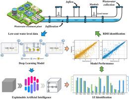
由于城市下水道系统降雨入渗(RDII)的空间异质性,准确识别RDII最严重的子集水区对下水道系统的后续管理至关重要。随着下水道系统监测传感器的增加,如何从丰富的水位数据中挖掘信息,识别严重RDII的子集水区是一个迫切需要解决的问题。传统的建模方法要么依赖于与水质和流量相关的大量数据,要么难以捕捉下水道系统的拓扑模式和复杂的非线性关系。因此,本研究提出了一种基于水位传感器和可解释深度学习算法的严重RDII子集水区识别方法。首先,根据传感器的位置将下水道系统划分为几个子集水区。利用低成本的水位监测数据,开发了干湿天气下每个子集水区的深度学习预测模型。随后使用可解释人工智能(XAI)方法对深度学习模型进行分析,以确定RDII的严重程度。在案例研究中对该方法进行了测试后,开发的深度学习模型被证明可以捕获不同监测点与外部降雨量之间的响应关系。此外,研究结果表明,利用简单的水位传感器,结合先进的可解释深度学习算法,可以有效识别每个子流域不同程度的RDII。该研究为基于低成本测量的RDII空间异质性识别提供了一种可行的方法,降低了监测和建模成本,具有广泛应用的潜力。
本文章由计算机程序翻译,如有差异,请以英文原文为准。

Spatial heterogeneity identification for rainfall-derived inflow and infiltration in urban sewer systems based on water level sensor networks: Insights from an interpretable deep learning method

Spatial heterogeneity identification for rainfall-derived inflow and infiltration in urban sewer systems based on water level sensor networks: Insights from an interpretable deep learning method
Due to the spatial heterogeneity of rainfall-derived inflow and infiltration (RDII) in urban sewer systems, accurately identifying the subcatchment with the most severe RDII is crucial for the subsequent management of the sewer system. With the increase in monitoring sensors in sewer systems, it is an urgent problem to mine information from the rich water level data to identify subcatchments with severe RDII. Traditional modeling methods either rely on large amounts of data related to water quality and flow, or struggle to capture the topological patterns and complex nonlinear relationships in sewer systems. Thus, this study proposes a severe RDII subcatchment identification method based on the water level sensors and interpretable deep learning algorithm. First, the sewer system is divided into several subcatchments based on the locations of the sensors. Deep learning prediction models for each subcatchment in dry and wet weather are developed using low-cost water level monitoring data. The deep learning models are subsequently analyzed using explainable artificial intelligence (XAI) method to identify RDII severity. After the method was tested in the case study, the developed deep learning models were proven to capture the response relationships between different monitoring sites and external rainfall. Moreover, the results show that the utilization of simple water level sensors, combined with advanced interpretable deep learning algorithms, can effectively identify different degrees of RDII in each subcatchment. This work provides a feasible method for spatial heterogeneity identification for RDII based on low-cost measurements that reduces monitoring and modeling costs, and has the potential for widespread application.
求助全文
通过发布文献求助,成功后即可免费获取论文全文。 去求助
来源期刊
Environmental Research
Environmental Research 环境科学-公共卫生、环境卫生与职业卫生
CiteScore
12.60
自引率
8.40%
发文量
2480
审稿时长
4.7 months
期刊介绍: The Environmental Research journal presents a broad range of interdisciplinary research, focused on addressing worldwide environmental concerns and featuring innovative findings. Our publication strives to explore relevant anthropogenic issues across various environmental sectors, showcasing practical applications in real-life settings.
×
引用
GB/T 7714-2015
复制
MLA
复制
APA
复制
导出至
BibTeX EndNote RefMan NoteFirst NoteExpress
×
提示
您的信息不完整,为了账户安全,请先补充。
现在去补充
×
提示
您因"违规操作"
具体请查看互助需知
我知道了
×
提示
确定
请完成安全验证×
copy
已复制链接
快去分享给好友吧!
我知道了
右上角分享
点击右上角分享
0
联系我们:info@booksci.cn Book学术提供免费学术资源搜索服务,方便国内外学者检索中英文文献。致力于提供最便捷和优质的服务体验。 Copyright © 2023 布克学术 All rights reserved.
京ICP备2023020795号-1
ghs 京公网安备 11010802042870号
Book学术文献互助
Book学术文献互助群
群 号:604180095
Book学术官方微信