{"title":"评估基于近景摄影测量的文化遗产文献数字表面模型","authors":"Shireen Younus Ismael, Farsat Heeto Abdulrahman","doi":"10.1007/s12517-025-12340-z","DOIUrl":null,"url":null,"abstract":"<div><p>Documentation of historic structures is widely recognized as an initial and crucial step in safeguarding tangible cultural heritage. Capturing and preserving detailed information (geometry and any architectural ornamental features) of these structures can ensure long-term conservation and provide valuable resources for research, education, and future conservation efforts. Selecting appropriate methods and techniques for documentation to create a comprehensive 3D representation of the historic structure is always a subject of research, and it is a challenging issue, specifically if the site is in an area with security concerns. This research aims to evaluate the Digital Surface Model of the Minaret of Amedy, a heritage site that is nationally registered. The data collection process was planned and executed, involving an e-survey GNSS receiver for measuring ground control points and a total station (TS, Leica TS06) for measuring control points on the four sides of the Minaret. Two hundred three images were taken by UAV, DJI Phantom 4 pro manually flown, and 196 images using Nikon D5300. The data was processed using the Agisoft Metashape photogrammetry software to create the final 3D Surface model and orthophotos. The RMS errors gained from UAV orthophotos are presented relative to the TS. Sub-centimeter accuracy for horizontal and vertical positions was obtained at low flight altitudes. The 3D digital models’ accuracy of the Minaret was assessed using conventional survey measurements, resulting in a maximum standard deviation in the coordinates of ±2.4 cm. The relative accuracy in distance measurement ranged from 0.00% to 0.20% and 0.00% to 0.30% in the horizontal and vertical directions, respectively. In addition, the maximum inclination of the Minaret in the East and West direction is about 18 cm and 13 cm, respectively, which were observed. These results reveal that the finding is valuable for future intervention and further research.\n</p></div>","PeriodicalId":476,"journal":{"name":"Arabian Journal of Geosciences","volume":"18 10","pages":""},"PeriodicalIF":1.8270,"publicationDate":"2025-10-02","publicationTypes":"Journal Article","fieldsOfStudy":null,"isOpenAccess":false,"openAccessPdf":"","citationCount":"0","resultStr":"{\"title\":\"Evaluate digital surface model for cultural heritage documentation based on close-range photogrammetry\",\"authors\":\"Shireen Younus Ismael, Farsat Heeto Abdulrahman\",\"doi\":\"10.1007/s12517-025-12340-z\",\"DOIUrl\":null,\"url\":null,\"abstract\":\"<div><p>Documentation of historic structures is widely recognized as an initial and crucial step in safeguarding tangible cultural heritage. Capturing and preserving detailed information (geometry and any architectural ornamental features) of these structures can ensure long-term conservation and provide valuable resources for research, education, and future conservation efforts. Selecting appropriate methods and techniques for documentation to create a comprehensive 3D representation of the historic structure is always a subject of research, and it is a challenging issue, specifically if the site is in an area with security concerns. This research aims to evaluate the Digital Surface Model of the Minaret of Amedy, a heritage site that is nationally registered. The data collection process was planned and executed, involving an e-survey GNSS receiver for measuring ground control points and a total station (TS, Leica TS06) for measuring control points on the four sides of the Minaret. Two hundred three images were taken by UAV, DJI Phantom 4 pro manually flown, and 196 images using Nikon D5300. The data was processed using the Agisoft Metashape photogrammetry software to create the final 3D Surface model and orthophotos. The RMS errors gained from UAV orthophotos are presented relative to the TS. Sub-centimeter accuracy for horizontal and vertical positions was obtained at low flight altitudes. The 3D digital models’ accuracy of the Minaret was assessed using conventional survey measurements, resulting in a maximum standard deviation in the coordinates of ±2.4 cm. The relative accuracy in distance measurement ranged from 0.00% to 0.20% and 0.00% to 0.30% in the horizontal and vertical directions, respectively. In addition, the maximum inclination of the Minaret in the East and West direction is about 18 cm and 13 cm, respectively, which were observed. These results reveal that the finding is valuable for future intervention and further research.\\n</p></div>\",\"PeriodicalId\":476,\"journal\":{\"name\":\"Arabian Journal of Geosciences\",\"volume\":\"18 10\",\"pages\":\"\"},\"PeriodicalIF\":1.8270,\"publicationDate\":\"2025-10-02\",\"publicationTypes\":\"Journal Article\",\"fieldsOfStudy\":null,\"isOpenAccess\":false,\"openAccessPdf\":\"\",\"citationCount\":\"0\",\"resultStr\":null,\"platform\":\"Semanticscholar\",\"paperid\":null,\"PeriodicalName\":\"Arabian Journal of Geosciences\",\"FirstCategoryId\":\"1085\",\"ListUrlMain\":\"https://link.springer.com/article/10.1007/s12517-025-12340-z\",\"RegionNum\":0,\"RegionCategory\":null,\"ArticlePicture\":[],\"TitleCN\":null,\"AbstractTextCN\":null,\"PMCID\":null,\"EPubDate\":\"\",\"PubModel\":\"\",\"JCR\":\"Q2\",\"JCRName\":\"Earth and Planetary Sciences\",\"Score\":null,\"Total\":0}","platform":"Semanticscholar","paperid":null,"PeriodicalName":"Arabian Journal of Geosciences","FirstCategoryId":"1085","ListUrlMain":"https://link.springer.com/article/10.1007/s12517-025-12340-z","RegionNum":0,"RegionCategory":null,"ArticlePicture":[],"TitleCN":null,"AbstractTextCN":null,"PMCID":null,"EPubDate":"","PubModel":"","JCR":"Q2","JCRName":"Earth and Planetary Sciences","Score":null,"Total":0}
Evaluate digital surface model for cultural heritage documentation based on close-range photogrammetry
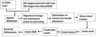
Documentation of historic structures is widely recognized as an initial and crucial step in safeguarding tangible cultural heritage. Capturing and preserving detailed information (geometry and any architectural ornamental features) of these structures can ensure long-term conservation and provide valuable resources for research, education, and future conservation efforts. Selecting appropriate methods and techniques for documentation to create a comprehensive 3D representation of the historic structure is always a subject of research, and it is a challenging issue, specifically if the site is in an area with security concerns. This research aims to evaluate the Digital Surface Model of the Minaret of Amedy, a heritage site that is nationally registered. The data collection process was planned and executed, involving an e-survey GNSS receiver for measuring ground control points and a total station (TS, Leica TS06) for measuring control points on the four sides of the Minaret. Two hundred three images were taken by UAV, DJI Phantom 4 pro manually flown, and 196 images using Nikon D5300. The data was processed using the Agisoft Metashape photogrammetry software to create the final 3D Surface model and orthophotos. The RMS errors gained from UAV orthophotos are presented relative to the TS. Sub-centimeter accuracy for horizontal and vertical positions was obtained at low flight altitudes. The 3D digital models’ accuracy of the Minaret was assessed using conventional survey measurements, resulting in a maximum standard deviation in the coordinates of ±2.4 cm. The relative accuracy in distance measurement ranged from 0.00% to 0.20% and 0.00% to 0.30% in the horizontal and vertical directions, respectively. In addition, the maximum inclination of the Minaret in the East and West direction is about 18 cm and 13 cm, respectively, which were observed. These results reveal that the finding is valuable for future intervention and further research.
期刊介绍:
The Arabian Journal of Geosciences is the official journal of the Saudi Society for Geosciences and publishes peer-reviewed original and review articles on the entire range of Earth Science themes, focused on, but not limited to, those that have regional significance to the Middle East and the Euro-Mediterranean Zone.
Key topics therefore include; geology, hydrogeology, earth system science, petroleum sciences, geophysics, seismology and crustal structures, tectonics, sedimentology, palaeontology, metamorphic and igneous petrology, natural hazards, environmental sciences and sustainable development, geoarchaeology, geomorphology, paleo-environment studies, oceanography, atmospheric sciences, GIS and remote sensing, geodesy, mineralogy, volcanology, geochemistry and metallogenesis.

 求助内容:
求助内容: 应助结果提醒方式:


