Manfredo A Turcios-Casco, Alexandre Schiavetti, Pablo Teta
{"title":"民间科学对“地方性”刺鼠的记录没有进行彻底的评估和检查。","authors":"Manfredo A Turcios-Casco, Alexandre Schiavetti, Pablo Teta","doi":"10.1186/s13104-025-07404-y","DOIUrl":null,"url":null,"abstract":"<p><strong>Objective: </strong>Citizen science supports conservation by contributing species occurrence data and promoting environmental education. However, the accuracy of these data remains a concern, particularly for endemic and poorly studied species. This study evaluates the spatial accuracy of citizen science records for the Roatán agouti (Dasyprocta ruatanica), an insular mammal endemic to the Bay Islands of Honduras. We specifically analysed geographic records sourced from the Global Biodiversity Information Facility (GBIF), mainly contributed through iNaturalist, to assess georeferencing quality and discuss potential misidentifications with the more widespread D. punctata.</p><p><strong>Results: </strong>Of 181 georeferenced records analysed, 80.11% were incorrectly placed-many located in the Atlantic Ocean rather than on Roatán-with a mean distance was 8.15 km (SD = 20.9 km), although the distribution was highly skewed due to a few extreme misplaced records. Furthermore, potential confusion between D. ruatanica and D. punctata was noted, likely due to morphological similarities and photographic limitations. These findings highlight the importance of careful precise geolocation and species identification when using citizen science data for conservation purposes, especially for insular endemics. Improved validation protocols and expert oversight are necessary to enhance the reliability of such records in biodiversity monitoring.</p>","PeriodicalId":9234,"journal":{"name":"BMC Research Notes","volume":"18 1","pages":"389"},"PeriodicalIF":1.7000,"publicationDate":"2025-09-29","publicationTypes":"Journal Article","fieldsOfStudy":null,"isOpenAccess":false,"openAccessPdf":"https://www.ncbi.nlm.nih.gov/pmc/articles/PMC12481986/pdf/","citationCount":"0","resultStr":"{\"title\":\"The records from citizen science of an \\\"endemic\\\" agouti are not thoroughly evaluated nor examined.\",\"authors\":\"Manfredo A Turcios-Casco, Alexandre Schiavetti, Pablo Teta\",\"doi\":\"10.1186/s13104-025-07404-y\",\"DOIUrl\":null,\"url\":null,\"abstract\":\"<p><strong>Objective: </strong>Citizen science supports conservation by contributing species occurrence data and promoting environmental education. However, the accuracy of these data remains a concern, particularly for endemic and poorly studied species. This study evaluates the spatial accuracy of citizen science records for the Roatán agouti (Dasyprocta ruatanica), an insular mammal endemic to the Bay Islands of Honduras. We specifically analysed geographic records sourced from the Global Biodiversity Information Facility (GBIF), mainly contributed through iNaturalist, to assess georeferencing quality and discuss potential misidentifications with the more widespread D. punctata.</p><p><strong>Results: </strong>Of 181 georeferenced records analysed, 80.11% were incorrectly placed-many located in the Atlantic Ocean rather than on Roatán-with a mean distance was 8.15 km (SD = 20.9 km), although the distribution was highly skewed due to a few extreme misplaced records. Furthermore, potential confusion between D. ruatanica and D. punctata was noted, likely due to morphological similarities and photographic limitations. These findings highlight the importance of careful precise geolocation and species identification when using citizen science data for conservation purposes, especially for insular endemics. Improved validation protocols and expert oversight are necessary to enhance the reliability of such records in biodiversity monitoring.</p>\",\"PeriodicalId\":9234,\"journal\":{\"name\":\"BMC Research Notes\",\"volume\":\"18 1\",\"pages\":\"389\"},\"PeriodicalIF\":1.7000,\"publicationDate\":\"2025-09-29\",\"publicationTypes\":\"Journal Article\",\"fieldsOfStudy\":null,\"isOpenAccess\":false,\"openAccessPdf\":\"https://www.ncbi.nlm.nih.gov/pmc/articles/PMC12481986/pdf/\",\"citationCount\":\"0\",\"resultStr\":null,\"platform\":\"Semanticscholar\",\"paperid\":null,\"PeriodicalName\":\"BMC Research Notes\",\"FirstCategoryId\":\"1085\",\"ListUrlMain\":\"https://doi.org/10.1186/s13104-025-07404-y\",\"RegionNum\":0,\"RegionCategory\":null,\"ArticlePicture\":[],\"TitleCN\":null,\"AbstractTextCN\":null,\"PMCID\":null,\"EPubDate\":\"\",\"PubModel\":\"\",\"JCR\":\"Q2\",\"JCRName\":\"MULTIDISCIPLINARY SCIENCES\",\"Score\":null,\"Total\":0}","platform":"Semanticscholar","paperid":null,"PeriodicalName":"BMC Research Notes","FirstCategoryId":"1085","ListUrlMain":"https://doi.org/10.1186/s13104-025-07404-y","RegionNum":0,"RegionCategory":null,"ArticlePicture":[],"TitleCN":null,"AbstractTextCN":null,"PMCID":null,"EPubDate":"","PubModel":"","JCR":"Q2","JCRName":"MULTIDISCIPLINARY SCIENCES","Score":null,"Total":0}
引用次数: 0
摘要
目的:公民科学通过提供物种发生数据和促进环境教育来支持保护。然而,这些数据的准确性仍然令人担忧,特别是对于地方性和研究较少的物种。本研究评估了洪都拉斯海湾群岛特有的岛屿哺乳动物Roatán刺鼠(Dasyprocta ruatanica)的公民科学记录的空间准确性。我们特别分析了来自全球生物多样性信息设施(GBIF)的地理记录,主要是通过iNaturalist提供的,以评估地理参考质量,并讨论了与更广泛分布的点刺木的潜在错误识别。结果:在分析的181个地理参考记录中,80.11%被错误地放置-许多位于大西洋而不是Roatán-with上,平均距离为8.15 km (SD = 20.9 km),尽管由于一些极端错位的记录,分布高度倾斜。此外,ruatanica和D. punctata之间可能存在混淆,可能是由于形态相似和摄影限制。这些发现强调了在使用公民科学数据用于保护目的时,特别是对于岛屿特有物种,仔细精确的地理定位和物种鉴定的重要性。为了提高生物多样性监测中这类记录的可靠性,改进验证方案和专家监督是必要的。
The records from citizen science of an "endemic" agouti are not thoroughly evaluated nor examined.
Objective: Citizen science supports conservation by contributing species occurrence data and promoting environmental education. However, the accuracy of these data remains a concern, particularly for endemic and poorly studied species. This study evaluates the spatial accuracy of citizen science records for the Roatán agouti (Dasyprocta ruatanica), an insular mammal endemic to the Bay Islands of Honduras. We specifically analysed geographic records sourced from the Global Biodiversity Information Facility (GBIF), mainly contributed through iNaturalist, to assess georeferencing quality and discuss potential misidentifications with the more widespread D. punctata.
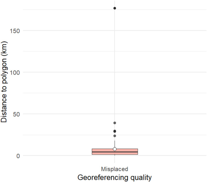
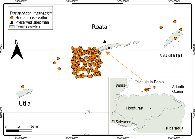
Results: Of 181 georeferenced records analysed, 80.11% were incorrectly placed-many located in the Atlantic Ocean rather than on Roatán-with a mean distance was 8.15 km (SD = 20.9 km), although the distribution was highly skewed due to a few extreme misplaced records. Furthermore, potential confusion between D. ruatanica and D. punctata was noted, likely due to morphological similarities and photographic limitations. These findings highlight the importance of careful precise geolocation and species identification when using citizen science data for conservation purposes, especially for insular endemics. Improved validation protocols and expert oversight are necessary to enhance the reliability of such records in biodiversity monitoring.
BMC Research NotesBiochemistry, Genetics and Molecular Biology-Biochemistry, Genetics and Molecular Biology (all)
CiteScore
3.60
自引率
0.00%
发文量
363
审稿时长
15 weeks
期刊介绍:
BMC Research Notes publishes scientifically valid research outputs that cannot be considered as full research or methodology articles. We support the research community across all scientific and clinical disciplines by providing an open access forum for sharing data and useful information; this includes, but is not limited to, updates to previous work, additions to established methods, short publications, null results, research proposals and data management plans.
 求助内容:
求助内容: 应助结果提醒方式:


