Megan P Powell, Webster Mufwambi, Alvira Z Hasan, Aliness M Dombola, Christine Prosperi, Rodgers Sakala, Kelvin Kapungu, Gershom Chongwe, Prachi Singh, Qiulin Wang, Stella Chewe, Francis D Mwansa, Constance Sakala, Elicah Kamiji, Patricia Bobo, Kennedy Matanda, Joan Manda, Amy K Winter, Molly Sauer, Andrea C Carcelen, Shaun A Truelove, William J Moss, Simon Mutembo
{"title":"赞比亚学校入学疫苗接种检查允许绘制未接种疫苗儿童的地图。","authors":"Megan P Powell, Webster Mufwambi, Alvira Z Hasan, Aliness M Dombola, Christine Prosperi, Rodgers Sakala, Kelvin Kapungu, Gershom Chongwe, Prachi Singh, Qiulin Wang, Stella Chewe, Francis D Mwansa, Constance Sakala, Elicah Kamiji, Patricia Bobo, Kennedy Matanda, Joan Manda, Amy K Winter, Molly Sauer, Andrea C Carcelen, Shaun A Truelove, William J Moss, Simon Mutembo","doi":"10.3390/vaccines13090924","DOIUrl":null,"url":null,"abstract":"<p><strong>Background: </strong>Geographic information systems (GIS) are a promising tool for mapping vaccination coverage and identifying missed communities, yet their use in low- and middle-income countries (LMICs) remains limited. In settings without standardized addresses such as schools or outreach sites, innovative methods are needed to collect and analyse spatial data. Schools offer a unique platform for identifying under-vaccinated children missed by routine or campaign efforts.</p><p><strong>Methods: </strong>During a pilot school vaccination screening program in Zambia, GIS reference maps of health facility catchment areas were developed from hand-drawn sketch maps, catchment area shapefiles, and coordinates of prominent landmarks. These maps were iteratively refined with input from local health staff. In caregiver interviews, data collectors used the maps to identify the child's zone of residence within the health facility catchment area. Vaccination status was extracted from paper registries used during screening. Geographic heat maps were generated in ArcGIS to visualize under-vaccination by zone.</p><p><strong>Results: </strong>Of 535 children screened across 25 zones, 29% were under-vaccinated. Under-vaccination varied by zone, with clusters of missed children identified, for example, 50% of children in Kabushi Zone 6 were under-vaccinated, compared with much lower rates elsewhere.</p><p><strong>Conclusions: </strong>Pairing school-based vaccination checks with GIS mapping offers a scalable approach to identifying missed communities in LMICs. This method enables spatial analysis without household visits, supporting targeted immunization planning where traditional data systems fall short. However, because the study was limited to children enrolled in five purposively selected schools, out-of-school children and those in other schools were not represented. This selection bias may underestimate the true extent of under-vaccination, and future evaluations should incorporate broader and more representative populations.</p>","PeriodicalId":23634,"journal":{"name":"Vaccines","volume":"13 9","pages":""},"PeriodicalIF":5.2000,"publicationDate":"2025-08-29","publicationTypes":"Journal Article","fieldsOfStudy":null,"isOpenAccess":false,"openAccessPdf":"https://www.ncbi.nlm.nih.gov/pmc/articles/PMC12474360/pdf/","citationCount":"0","resultStr":"{\"title\":\"School Entry Vaccination Checks Allow Mapping of Under-Vaccinated Children in Zambia.\",\"authors\":\"Megan P Powell, Webster Mufwambi, Alvira Z Hasan, Aliness M Dombola, Christine Prosperi, Rodgers Sakala, Kelvin Kapungu, Gershom Chongwe, Prachi Singh, Qiulin Wang, Stella Chewe, Francis D Mwansa, Constance Sakala, Elicah Kamiji, Patricia Bobo, Kennedy Matanda, Joan Manda, Amy K Winter, Molly Sauer, Andrea C Carcelen, Shaun A Truelove, William J Moss, Simon Mutembo\",\"doi\":\"10.3390/vaccines13090924\",\"DOIUrl\":null,\"url\":null,\"abstract\":\"<p><strong>Background: </strong>Geographic information systems (GIS) are a promising tool for mapping vaccination coverage and identifying missed communities, yet their use in low- and middle-income countries (LMICs) remains limited. In settings without standardized addresses such as schools or outreach sites, innovative methods are needed to collect and analyse spatial data. Schools offer a unique platform for identifying under-vaccinated children missed by routine or campaign efforts.</p><p><strong>Methods: </strong>During a pilot school vaccination screening program in Zambia, GIS reference maps of health facility catchment areas were developed from hand-drawn sketch maps, catchment area shapefiles, and coordinates of prominent landmarks. These maps were iteratively refined with input from local health staff. In caregiver interviews, data collectors used the maps to identify the child's zone of residence within the health facility catchment area. Vaccination status was extracted from paper registries used during screening. Geographic heat maps were generated in ArcGIS to visualize under-vaccination by zone.</p><p><strong>Results: </strong>Of 535 children screened across 25 zones, 29% were under-vaccinated. Under-vaccination varied by zone, with clusters of missed children identified, for example, 50% of children in Kabushi Zone 6 were under-vaccinated, compared with much lower rates elsewhere.</p><p><strong>Conclusions: </strong>Pairing school-based vaccination checks with GIS mapping offers a scalable approach to identifying missed communities in LMICs. This method enables spatial analysis without household visits, supporting targeted immunization planning where traditional data systems fall short. However, because the study was limited to children enrolled in five purposively selected schools, out-of-school children and those in other schools were not represented. This selection bias may underestimate the true extent of under-vaccination, and future evaluations should incorporate broader and more representative populations.</p>\",\"PeriodicalId\":23634,\"journal\":{\"name\":\"Vaccines\",\"volume\":\"13 9\",\"pages\":\"\"},\"PeriodicalIF\":5.2000,\"publicationDate\":\"2025-08-29\",\"publicationTypes\":\"Journal Article\",\"fieldsOfStudy\":null,\"isOpenAccess\":false,\"openAccessPdf\":\"https://www.ncbi.nlm.nih.gov/pmc/articles/PMC12474360/pdf/\",\"citationCount\":\"0\",\"resultStr\":null,\"platform\":\"Semanticscholar\",\"paperid\":null,\"PeriodicalName\":\"Vaccines\",\"FirstCategoryId\":\"3\",\"ListUrlMain\":\"https://doi.org/10.3390/vaccines13090924\",\"RegionNum\":3,\"RegionCategory\":\"医学\",\"ArticlePicture\":[],\"TitleCN\":null,\"AbstractTextCN\":null,\"PMCID\":null,\"EPubDate\":\"\",\"PubModel\":\"\",\"JCR\":\"Q1\",\"JCRName\":\"IMMUNOLOGY\",\"Score\":null,\"Total\":0}","platform":"Semanticscholar","paperid":null,"PeriodicalName":"Vaccines","FirstCategoryId":"3","ListUrlMain":"https://doi.org/10.3390/vaccines13090924","RegionNum":3,"RegionCategory":"医学","ArticlePicture":[],"TitleCN":null,"AbstractTextCN":null,"PMCID":null,"EPubDate":"","PubModel":"","JCR":"Q1","JCRName":"IMMUNOLOGY","Score":null,"Total":0}
School Entry Vaccination Checks Allow Mapping of Under-Vaccinated Children in Zambia.
Background: Geographic information systems (GIS) are a promising tool for mapping vaccination coverage and identifying missed communities, yet their use in low- and middle-income countries (LMICs) remains limited. In settings without standardized addresses such as schools or outreach sites, innovative methods are needed to collect and analyse spatial data. Schools offer a unique platform for identifying under-vaccinated children missed by routine or campaign efforts.
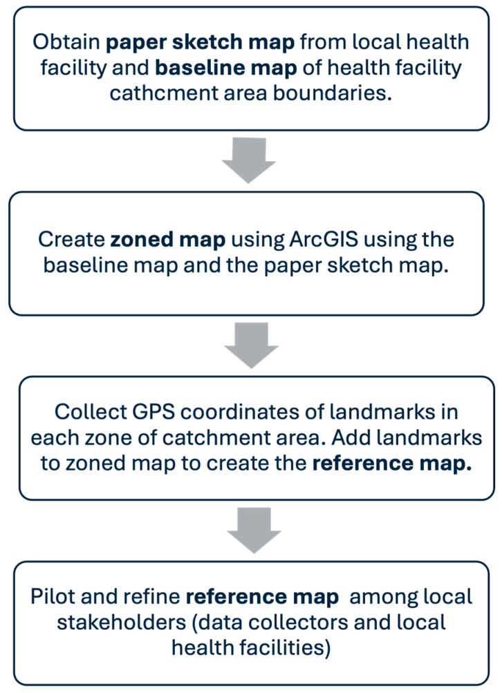
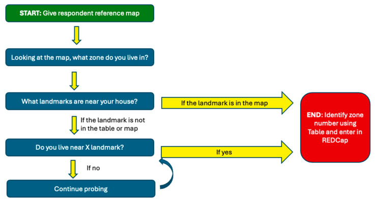
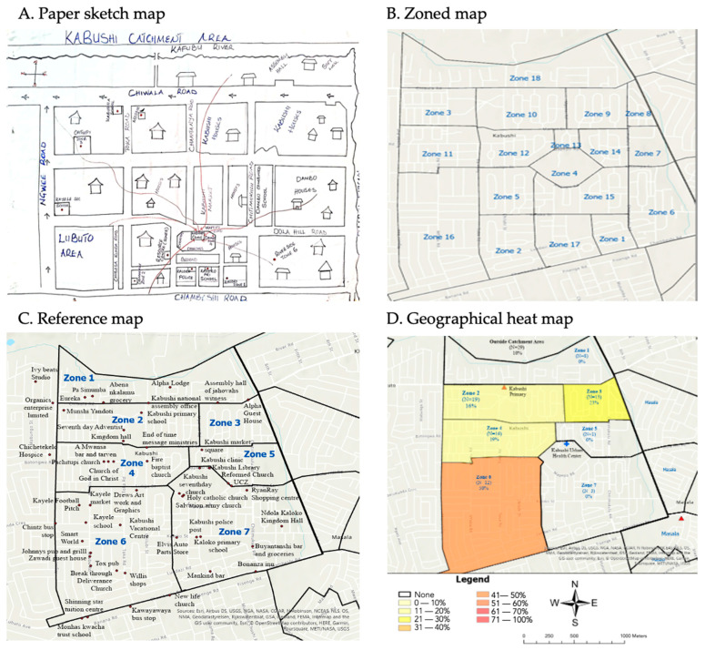
Methods: During a pilot school vaccination screening program in Zambia, GIS reference maps of health facility catchment areas were developed from hand-drawn sketch maps, catchment area shapefiles, and coordinates of prominent landmarks. These maps were iteratively refined with input from local health staff. In caregiver interviews, data collectors used the maps to identify the child's zone of residence within the health facility catchment area. Vaccination status was extracted from paper registries used during screening. Geographic heat maps were generated in ArcGIS to visualize under-vaccination by zone.
Results: Of 535 children screened across 25 zones, 29% were under-vaccinated. Under-vaccination varied by zone, with clusters of missed children identified, for example, 50% of children in Kabushi Zone 6 were under-vaccinated, compared with much lower rates elsewhere.
Conclusions: Pairing school-based vaccination checks with GIS mapping offers a scalable approach to identifying missed communities in LMICs. This method enables spatial analysis without household visits, supporting targeted immunization planning where traditional data systems fall short. However, because the study was limited to children enrolled in five purposively selected schools, out-of-school children and those in other schools were not represented. This selection bias may underestimate the true extent of under-vaccination, and future evaluations should incorporate broader and more representative populations.
VaccinesPharmacology, Toxicology and Pharmaceutics-Pharmacology
CiteScore
8.90
自引率
16.70%
发文量
1853
审稿时长
18.06 days
期刊介绍:
Vaccines (ISSN 2076-393X) is an international, peer-reviewed open access journal focused on laboratory and clinical vaccine research, utilization and immunization. Vaccines publishes high quality reviews, regular research papers, communications and case reports.
 求助内容:
求助内容: 应助结果提醒方式:


