Lukman Musa Adamu, Nuhu George Obaje, Adejimi James Adeoye, Razaq Gboyega Oladimeji
{"title":"尼日利亚中部贝努埃海槽Akiri地区高分辨率航磁、辐射和野外数据的岩石-结构深度解释:对油气远景的影响","authors":"Lukman Musa Adamu, Nuhu George Obaje, Adejimi James Adeoye, Razaq Gboyega Oladimeji","doi":"10.1007/s12517-025-12293-3","DOIUrl":null,"url":null,"abstract":"<div><p>Nigeria’s renewed efforts to increase its declining reserves by exploring oil and gas resources in Cretaceous sedimentary basins have led to the necessity to reevaluate hydrocarbon potentials in the Central Benue Trough. This study uses field data sets, satellite-based observations, organic geochemistry, aeroradiometric data, and aeromagnetic data to look at intrasedimentary volcanic formations and detailed aeromagnetic and radiometric data in the Akiri region of the Central Benue Trough. We apply various enhancement methodologies to chart the structural and stratigraphic layout of the basement and enhance depth delineation, extending from 55.17 m to approximately 6735 m. Among these techniques for improving things are the first vertical derivative, analytic signal, source parameter imaging, Euler deconvolution, 2D power spectrum, center for exploration targeting (grid and porphyry), ratio maps, ternary maps, percentage potassium (%K), percentage thorium (eTh), and radiometric analyses. The results show six lithological units, several magmatic intrusions, and undulating and highly faulted basement surfaces with horst and graben structures. We determine shale to be the principal source rock for hydrocarbon maturation. The Central Benue Trough’s center region has a higher potential for hydrocarbon occurrence. However, further geophysical (seismic and well) studies are necessary to accurately locate and evaluate possible hydrocarbon reserves. Field and organic geochemical validation confirm the existence of important mapped structures. This gives more evidence that oil and gas could be extracted from the coal and shale formations.</p></div>","PeriodicalId":476,"journal":{"name":"Arabian Journal of Geosciences","volume":"18 8","pages":""},"PeriodicalIF":1.8270,"publicationDate":"2025-07-23","publicationTypes":"Journal Article","fieldsOfStudy":null,"isOpenAccess":false,"openAccessPdf":"","citationCount":"0","resultStr":"{\"title\":\"Litho-structural–depth interpretation of high-resolution aeromagnetic, radiometric, and field data over Akiri area, Central Benue Trough, Nigeria: implications for hydrocarbon prospectivity\",\"authors\":\"Lukman Musa Adamu, Nuhu George Obaje, Adejimi James Adeoye, Razaq Gboyega Oladimeji\",\"doi\":\"10.1007/s12517-025-12293-3\",\"DOIUrl\":null,\"url\":null,\"abstract\":\"<div><p>Nigeria’s renewed efforts to increase its declining reserves by exploring oil and gas resources in Cretaceous sedimentary basins have led to the necessity to reevaluate hydrocarbon potentials in the Central Benue Trough. This study uses field data sets, satellite-based observations, organic geochemistry, aeroradiometric data, and aeromagnetic data to look at intrasedimentary volcanic formations and detailed aeromagnetic and radiometric data in the Akiri region of the Central Benue Trough. We apply various enhancement methodologies to chart the structural and stratigraphic layout of the basement and enhance depth delineation, extending from 55.17 m to approximately 6735 m. Among these techniques for improving things are the first vertical derivative, analytic signal, source parameter imaging, Euler deconvolution, 2D power spectrum, center for exploration targeting (grid and porphyry), ratio maps, ternary maps, percentage potassium (%K), percentage thorium (eTh), and radiometric analyses. The results show six lithological units, several magmatic intrusions, and undulating and highly faulted basement surfaces with horst and graben structures. We determine shale to be the principal source rock for hydrocarbon maturation. The Central Benue Trough’s center region has a higher potential for hydrocarbon occurrence. However, further geophysical (seismic and well) studies are necessary to accurately locate and evaluate possible hydrocarbon reserves. Field and organic geochemical validation confirm the existence of important mapped structures. This gives more evidence that oil and gas could be extracted from the coal and shale formations.</p></div>\",\"PeriodicalId\":476,\"journal\":{\"name\":\"Arabian Journal of Geosciences\",\"volume\":\"18 8\",\"pages\":\"\"},\"PeriodicalIF\":1.8270,\"publicationDate\":\"2025-07-23\",\"publicationTypes\":\"Journal Article\",\"fieldsOfStudy\":null,\"isOpenAccess\":false,\"openAccessPdf\":\"\",\"citationCount\":\"0\",\"resultStr\":null,\"platform\":\"Semanticscholar\",\"paperid\":null,\"PeriodicalName\":\"Arabian Journal of Geosciences\",\"FirstCategoryId\":\"1085\",\"ListUrlMain\":\"https://link.springer.com/article/10.1007/s12517-025-12293-3\",\"RegionNum\":0,\"RegionCategory\":null,\"ArticlePicture\":[],\"TitleCN\":null,\"AbstractTextCN\":null,\"PMCID\":null,\"EPubDate\":\"\",\"PubModel\":\"\",\"JCR\":\"Q2\",\"JCRName\":\"Earth and Planetary Sciences\",\"Score\":null,\"Total\":0}","platform":"Semanticscholar","paperid":null,"PeriodicalName":"Arabian Journal of Geosciences","FirstCategoryId":"1085","ListUrlMain":"https://link.springer.com/article/10.1007/s12517-025-12293-3","RegionNum":0,"RegionCategory":null,"ArticlePicture":[],"TitleCN":null,"AbstractTextCN":null,"PMCID":null,"EPubDate":"","PubModel":"","JCR":"Q2","JCRName":"Earth and Planetary Sciences","Score":null,"Total":0}
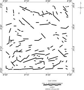
Litho-structural–depth interpretation of high-resolution aeromagnetic, radiometric, and field data over Akiri area, Central Benue Trough, Nigeria: implications for hydrocarbon prospectivity
Nigeria’s renewed efforts to increase its declining reserves by exploring oil and gas resources in Cretaceous sedimentary basins have led to the necessity to reevaluate hydrocarbon potentials in the Central Benue Trough. This study uses field data sets, satellite-based observations, organic geochemistry, aeroradiometric data, and aeromagnetic data to look at intrasedimentary volcanic formations and detailed aeromagnetic and radiometric data in the Akiri region of the Central Benue Trough. We apply various enhancement methodologies to chart the structural and stratigraphic layout of the basement and enhance depth delineation, extending from 55.17 m to approximately 6735 m. Among these techniques for improving things are the first vertical derivative, analytic signal, source parameter imaging, Euler deconvolution, 2D power spectrum, center for exploration targeting (grid and porphyry), ratio maps, ternary maps, percentage potassium (%K), percentage thorium (eTh), and radiometric analyses. The results show six lithological units, several magmatic intrusions, and undulating and highly faulted basement surfaces with horst and graben structures. We determine shale to be the principal source rock for hydrocarbon maturation. The Central Benue Trough’s center region has a higher potential for hydrocarbon occurrence. However, further geophysical (seismic and well) studies are necessary to accurately locate and evaluate possible hydrocarbon reserves. Field and organic geochemical validation confirm the existence of important mapped structures. This gives more evidence that oil and gas could be extracted from the coal and shale formations.
期刊介绍:
The Arabian Journal of Geosciences is the official journal of the Saudi Society for Geosciences and publishes peer-reviewed original and review articles on the entire range of Earth Science themes, focused on, but not limited to, those that have regional significance to the Middle East and the Euro-Mediterranean Zone.
Key topics therefore include; geology, hydrogeology, earth system science, petroleum sciences, geophysics, seismology and crustal structures, tectonics, sedimentology, palaeontology, metamorphic and igneous petrology, natural hazards, environmental sciences and sustainable development, geoarchaeology, geomorphology, paleo-environment studies, oceanography, atmospheric sciences, GIS and remote sensing, geodesy, mineralogy, volcanology, geochemistry and metallogenesis.

 求助内容:
求助内容: 应助结果提醒方式:


