Md Sarif Khan, Anantha Rao Duragasi, Ravi Kumar Gumma
{"title":"利用GIS-AHP和AR可行性评估在印度安得拉邦Prakasam地区划定地下水补给潜力区","authors":"Md Sarif Khan, Anantha Rao Duragasi, Ravi Kumar Gumma","doi":"10.1007/s12517-025-12296-0","DOIUrl":null,"url":null,"abstract":"<div><p>In water-stressed areas, delineating feasible zones for artificial recharge (AR) to groundwater and pinpointing suitable sites are a challenging task. This study applies a GIS-based analytical hierarchy process (AHP) to delineate groundwater recharge potential zones (GRPZs) by integrating multiple thematic layers. Pairwise comparisons and eigenvalue calculations yielded a consistency ratio (CR) of 0.09, confirming the reliability of the assigned weights. The resulting GRPZs map classifies the 14,122 sq.km study area into five categories: very high (9%), high (17%), moderate (29%), low (31%), and very low (14%). Northwestern and central areas show high recharge feasibility, while the eastern part has low to very low potential. The study also focuses on optimizing and distributing AR structures through a scientific approach for effective planning. Estimations are based on parameters such as weathered zone thickness, total area, rainfall, aquifer volume, water level, runoff, conductivity, and field data like well inventories, lithologs, and yield data. The total estimated unsaturated aquifer volume is 114,135 million cubic meters (MCM), which 124 MCM of surplus rainfall runoff available for recharge. Based on the analysis, a total 3602 artificial recharge (AR) structures, i.e., 2471 check dams (CDs) and 1131 percolation tanks (PTs) have been identified as feasible after accounting 7744 existing structures. Of these, 279 new AR structures (CDs and PTs with recharge shafts (RS)) are proposed in very high to moderate GRPZs. These are expected to harvest 7.17 MCM of rainwater, with 4.30 MCM recharged in drought-prone areas and also promoting farm-dug ponds aid sustainable, cost-effective groundwater recharge. Coastal and shallow water table regions are unsuitable for such interventions.\n</p></div>","PeriodicalId":476,"journal":{"name":"Arabian Journal of Geosciences","volume":"18 9","pages":""},"PeriodicalIF":1.8270,"publicationDate":"2025-08-04","publicationTypes":"Journal Article","fieldsOfStudy":null,"isOpenAccess":false,"openAccessPdf":"","citationCount":"0","resultStr":"{\"title\":\"Delineation of groundwater recharge potential zones using GIS-AHP and AR feasibility assessment in Prakasam district, Andhra Pradesh, India\",\"authors\":\"Md Sarif Khan, Anantha Rao Duragasi, Ravi Kumar Gumma\",\"doi\":\"10.1007/s12517-025-12296-0\",\"DOIUrl\":null,\"url\":null,\"abstract\":\"<div><p>In water-stressed areas, delineating feasible zones for artificial recharge (AR) to groundwater and pinpointing suitable sites are a challenging task. This study applies a GIS-based analytical hierarchy process (AHP) to delineate groundwater recharge potential zones (GRPZs) by integrating multiple thematic layers. Pairwise comparisons and eigenvalue calculations yielded a consistency ratio (CR) of 0.09, confirming the reliability of the assigned weights. The resulting GRPZs map classifies the 14,122 sq.km study area into five categories: very high (9%), high (17%), moderate (29%), low (31%), and very low (14%). Northwestern and central areas show high recharge feasibility, while the eastern part has low to very low potential. The study also focuses on optimizing and distributing AR structures through a scientific approach for effective planning. Estimations are based on parameters such as weathered zone thickness, total area, rainfall, aquifer volume, water level, runoff, conductivity, and field data like well inventories, lithologs, and yield data. The total estimated unsaturated aquifer volume is 114,135 million cubic meters (MCM), which 124 MCM of surplus rainfall runoff available for recharge. Based on the analysis, a total 3602 artificial recharge (AR) structures, i.e., 2471 check dams (CDs) and 1131 percolation tanks (PTs) have been identified as feasible after accounting 7744 existing structures. Of these, 279 new AR structures (CDs and PTs with recharge shafts (RS)) are proposed in very high to moderate GRPZs. These are expected to harvest 7.17 MCM of rainwater, with 4.30 MCM recharged in drought-prone areas and also promoting farm-dug ponds aid sustainable, cost-effective groundwater recharge. Coastal and shallow water table regions are unsuitable for such interventions.\\n</p></div>\",\"PeriodicalId\":476,\"journal\":{\"name\":\"Arabian Journal of Geosciences\",\"volume\":\"18 9\",\"pages\":\"\"},\"PeriodicalIF\":1.8270,\"publicationDate\":\"2025-08-04\",\"publicationTypes\":\"Journal Article\",\"fieldsOfStudy\":null,\"isOpenAccess\":false,\"openAccessPdf\":\"\",\"citationCount\":\"0\",\"resultStr\":null,\"platform\":\"Semanticscholar\",\"paperid\":null,\"PeriodicalName\":\"Arabian Journal of Geosciences\",\"FirstCategoryId\":\"1085\",\"ListUrlMain\":\"https://link.springer.com/article/10.1007/s12517-025-12296-0\",\"RegionNum\":0,\"RegionCategory\":null,\"ArticlePicture\":[],\"TitleCN\":null,\"AbstractTextCN\":null,\"PMCID\":null,\"EPubDate\":\"\",\"PubModel\":\"\",\"JCR\":\"Q2\",\"JCRName\":\"Earth and Planetary Sciences\",\"Score\":null,\"Total\":0}","platform":"Semanticscholar","paperid":null,"PeriodicalName":"Arabian Journal of Geosciences","FirstCategoryId":"1085","ListUrlMain":"https://link.springer.com/article/10.1007/s12517-025-12296-0","RegionNum":0,"RegionCategory":null,"ArticlePicture":[],"TitleCN":null,"AbstractTextCN":null,"PMCID":null,"EPubDate":"","PubModel":"","JCR":"Q2","JCRName":"Earth and Planetary Sciences","Score":null,"Total":0}
Delineation of groundwater recharge potential zones using GIS-AHP and AR feasibility assessment in Prakasam district, Andhra Pradesh, India
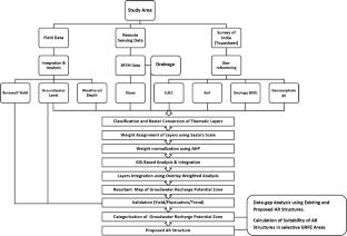
In water-stressed areas, delineating feasible zones for artificial recharge (AR) to groundwater and pinpointing suitable sites are a challenging task. This study applies a GIS-based analytical hierarchy process (AHP) to delineate groundwater recharge potential zones (GRPZs) by integrating multiple thematic layers. Pairwise comparisons and eigenvalue calculations yielded a consistency ratio (CR) of 0.09, confirming the reliability of the assigned weights. The resulting GRPZs map classifies the 14,122 sq.km study area into five categories: very high (9%), high (17%), moderate (29%), low (31%), and very low (14%). Northwestern and central areas show high recharge feasibility, while the eastern part has low to very low potential. The study also focuses on optimizing and distributing AR structures through a scientific approach for effective planning. Estimations are based on parameters such as weathered zone thickness, total area, rainfall, aquifer volume, water level, runoff, conductivity, and field data like well inventories, lithologs, and yield data. The total estimated unsaturated aquifer volume is 114,135 million cubic meters (MCM), which 124 MCM of surplus rainfall runoff available for recharge. Based on the analysis, a total 3602 artificial recharge (AR) structures, i.e., 2471 check dams (CDs) and 1131 percolation tanks (PTs) have been identified as feasible after accounting 7744 existing structures. Of these, 279 new AR structures (CDs and PTs with recharge shafts (RS)) are proposed in very high to moderate GRPZs. These are expected to harvest 7.17 MCM of rainwater, with 4.30 MCM recharged in drought-prone areas and also promoting farm-dug ponds aid sustainable, cost-effective groundwater recharge. Coastal and shallow water table regions are unsuitable for such interventions.
期刊介绍:
The Arabian Journal of Geosciences is the official journal of the Saudi Society for Geosciences and publishes peer-reviewed original and review articles on the entire range of Earth Science themes, focused on, but not limited to, those that have regional significance to the Middle East and the Euro-Mediterranean Zone.
Key topics therefore include; geology, hydrogeology, earth system science, petroleum sciences, geophysics, seismology and crustal structures, tectonics, sedimentology, palaeontology, metamorphic and igneous petrology, natural hazards, environmental sciences and sustainable development, geoarchaeology, geomorphology, paleo-environment studies, oceanography, atmospheric sciences, GIS and remote sensing, geodesy, mineralogy, volcanology, geochemistry and metallogenesis.

 求助内容:
求助内容: 应助结果提醒方式:


