{"title":"空间大地观测原始数据的自动验证、元信息采集与结构化及其定性分析","authors":"S. I. Kuzikov, D. V. Kenigsberg","doi":"10.3103/S0747923925700069","DOIUrl":null,"url":null,"abstract":"<p>Over past decades, the scope and number of national Global Navigation Satellite Systems (GNSS) have rapidly increased. To determine a geodetic position with high accuracy, many different GNSS receivers are used. The data from them are presented in common RINEX format for information exchange and further processing. By the 45th anniversary of the scientific activities of the Research Station of the Russian Academy of Sciences in Central Asia, we have collected an archive of GNSS observations, which includes about 300 000 days of fixing positions for more than 1500 geodetic reference sites with a data recording frequency of 30 s. The quality of coordinate calculations and site displacement velocity strongly depends on correct formatting of source data in RINEX files. This is clear from the experience of working with the high-precision software packages GAMIT/GLOBK and Bernese GNSS Software. We have created the RinexVER program for stream fixing of typical errors during processing of a large number of daily RINEX files (10 000–15 000 observations per year), for their sorting and formation of a structured archive, and for collecting the necessary information about them. Thus, the work of an expert on fixing RINEX file can be reduced by 50 times. In addition, it is possible to increase the accuracy in calculating time series of coordinates and velocity vectors for observation sites in geodynamic studies.</p>","PeriodicalId":45174,"journal":{"name":"Seismic Instruments","volume":"60 1-3","pages":"10 - 18"},"PeriodicalIF":0.3000,"publicationDate":"2025-06-02","publicationTypes":"Journal Article","fieldsOfStudy":null,"isOpenAccess":false,"openAccessPdf":"","citationCount":"0","resultStr":"{\"title\":\"Automatic Verification, Collection of Metainformation and Structuring of Primary Data of Space Geodetic Observations for Their Qualitative Analysis\",\"authors\":\"S. I. Kuzikov, D. V. Kenigsberg\",\"doi\":\"10.3103/S0747923925700069\",\"DOIUrl\":null,\"url\":null,\"abstract\":\"<p>Over past decades, the scope and number of national Global Navigation Satellite Systems (GNSS) have rapidly increased. To determine a geodetic position with high accuracy, many different GNSS receivers are used. The data from them are presented in common RINEX format for information exchange and further processing. By the 45th anniversary of the scientific activities of the Research Station of the Russian Academy of Sciences in Central Asia, we have collected an archive of GNSS observations, which includes about 300 000 days of fixing positions for more than 1500 geodetic reference sites with a data recording frequency of 30 s. The quality of coordinate calculations and site displacement velocity strongly depends on correct formatting of source data in RINEX files. This is clear from the experience of working with the high-precision software packages GAMIT/GLOBK and Bernese GNSS Software. We have created the RinexVER program for stream fixing of typical errors during processing of a large number of daily RINEX files (10 000–15 000 observations per year), for their sorting and formation of a structured archive, and for collecting the necessary information about them. Thus, the work of an expert on fixing RINEX file can be reduced by 50 times. In addition, it is possible to increase the accuracy in calculating time series of coordinates and velocity vectors for observation sites in geodynamic studies.</p>\",\"PeriodicalId\":45174,\"journal\":{\"name\":\"Seismic Instruments\",\"volume\":\"60 1-3\",\"pages\":\"10 - 18\"},\"PeriodicalIF\":0.3000,\"publicationDate\":\"2025-06-02\",\"publicationTypes\":\"Journal Article\",\"fieldsOfStudy\":null,\"isOpenAccess\":false,\"openAccessPdf\":\"\",\"citationCount\":\"0\",\"resultStr\":null,\"platform\":\"Semanticscholar\",\"paperid\":null,\"PeriodicalName\":\"Seismic Instruments\",\"FirstCategoryId\":\"1085\",\"ListUrlMain\":\"https://link.springer.com/article/10.3103/S0747923925700069\",\"RegionNum\":0,\"RegionCategory\":null,\"ArticlePicture\":[],\"TitleCN\":null,\"AbstractTextCN\":null,\"PMCID\":null,\"EPubDate\":\"\",\"PubModel\":\"\",\"JCR\":\"Q4\",\"JCRName\":\"GEOCHEMISTRY & GEOPHYSICS\",\"Score\":null,\"Total\":0}","platform":"Semanticscholar","paperid":null,"PeriodicalName":"Seismic Instruments","FirstCategoryId":"1085","ListUrlMain":"https://link.springer.com/article/10.3103/S0747923925700069","RegionNum":0,"RegionCategory":null,"ArticlePicture":[],"TitleCN":null,"AbstractTextCN":null,"PMCID":null,"EPubDate":"","PubModel":"","JCR":"Q4","JCRName":"GEOCHEMISTRY & GEOPHYSICS","Score":null,"Total":0}
Automatic Verification, Collection of Metainformation and Structuring of Primary Data of Space Geodetic Observations for Their Qualitative Analysis
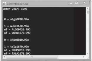
Over past decades, the scope and number of national Global Navigation Satellite Systems (GNSS) have rapidly increased. To determine a geodetic position with high accuracy, many different GNSS receivers are used. The data from them are presented in common RINEX format for information exchange and further processing. By the 45th anniversary of the scientific activities of the Research Station of the Russian Academy of Sciences in Central Asia, we have collected an archive of GNSS observations, which includes about 300 000 days of fixing positions for more than 1500 geodetic reference sites with a data recording frequency of 30 s. The quality of coordinate calculations and site displacement velocity strongly depends on correct formatting of source data in RINEX files. This is clear from the experience of working with the high-precision software packages GAMIT/GLOBK and Bernese GNSS Software. We have created the RinexVER program for stream fixing of typical errors during processing of a large number of daily RINEX files (10 000–15 000 observations per year), for their sorting and formation of a structured archive, and for collecting the necessary information about them. Thus, the work of an expert on fixing RINEX file can be reduced by 50 times. In addition, it is possible to increase the accuracy in calculating time series of coordinates and velocity vectors for observation sites in geodynamic studies.
期刊介绍:
Seismic Instruments is a journal devoted to the description of geophysical instruments used in seismic research. In addition to covering the actual instruments for registering seismic waves, substantial room is devoted to solving instrumental-methodological problems of geophysical monitoring, applying various methods that are used to search for earthquake precursors, to studying earthquake nucleation processes and to monitoring natural and technogenous processes. The description of the construction, working elements, and technical characteristics of the instruments, as well as some results of implementation of the instruments and interpretation of the results are given. Attention is paid to seismic monitoring data and earthquake catalog quality Analysis.
 求助内容:
求助内容: 应助结果提醒方式:


