Ravi Kanth Sriwastav, Narsiram Gurjar, STG Raghukanth
{"title":"基于修正Mercalli烈度的印度概率地震危险性评估与区划","authors":"Ravi Kanth Sriwastav, Narsiram Gurjar, STG Raghukanth","doi":"10.1007/s10518-025-02166-1","DOIUrl":null,"url":null,"abstract":"<div><p>The probabilistic seismic hazard assessment (PSHA) incorporates probabilistic elements such as earthquake source, magnitude, distance, and spectral distribution. The approach has been widely used for developing hazard maps and zone maps considering Peak ground acceleration (PGA) as the intensity measure (IM). Conversely in India, earthquake intensity, which is crucial for measuring seismic events without instruments, has been the primary input for seismic zone maps in the past without including probabilistic rigor. PSHA-based zonation using PGA often overlooks spatial damage distribution, while MMI-based zonation without probabilistic approaches fails to account for seismic variability, source characteristics, and site effects. To address these limitations, this study introduces an intensity-based PSHA framework for the Indian subcontinent. Leveraging historical and contemporary intensity data, it enhances hazard assessments by accounting for past damage distribution and spatial variations in the built environment, producing hazard maps that align more closely with observed seismic impacts. A region-specific Intensity Prediction Model (IPM) for Modified Mercalli Intensity (MMI) is first developed using an artificial neural network (ANN) trained on a comprehensive intensity dataset. The Indian subcontinent is classified into four tectonic domains while developing IPM: (i) Himalayan Active Crustal Region, (ii) Indo-Gangetic Basin, (iii) Stable Continental or Indian Shield Region, and (iv) Indo-Myanmar and Andaman-Nicobar Subduction region. Utilizing this IPM, hazard assessment is conducted employing a logic-tree approach to address epistemic uncertainties, generating MMI-based hazard curves and maps. Intensity-based seismic zone maps are created using the natural break algorithm. A comparative analysis evaluates the effectiveness of MMI-based seismic zoning versus traditional PGA-based methods, demonstrating its potential for more accurate hazard characterization in India’s diverse tectonic settings. The findings suggest that rather than considering PGA- and MMI-based PSHA approaches as competing methods, a rational integration of both can lead to an improved seismic hazard characterization. PGA-based maps remain essential for engineering design and structural performance assessment, whereas MMI-based maps provide critical insights into spatial damage patterns, particularly in regions where historical intensity records are available. By leveraging the strengths of both approaches, a more holistic and reliable seismic zonation map can be developed to better account for regional tectonic variability and real-world earthquake impacts.</p></div>","PeriodicalId":9364,"journal":{"name":"Bulletin of Earthquake Engineering","volume":"23 8","pages":"3057 - 3084"},"PeriodicalIF":4.1000,"publicationDate":"2025-04-18","publicationTypes":"Journal Article","fieldsOfStudy":null,"isOpenAccess":false,"openAccessPdf":"","citationCount":"0","resultStr":"{\"title\":\"Modified Mercalli intensity-based probabilistic seismic hazard assessment and zonation of India\",\"authors\":\"Ravi Kanth Sriwastav, Narsiram Gurjar, STG Raghukanth\",\"doi\":\"10.1007/s10518-025-02166-1\",\"DOIUrl\":null,\"url\":null,\"abstract\":\"<div><p>The probabilistic seismic hazard assessment (PSHA) incorporates probabilistic elements such as earthquake source, magnitude, distance, and spectral distribution. The approach has been widely used for developing hazard maps and zone maps considering Peak ground acceleration (PGA) as the intensity measure (IM). Conversely in India, earthquake intensity, which is crucial for measuring seismic events without instruments, has been the primary input for seismic zone maps in the past without including probabilistic rigor. PSHA-based zonation using PGA often overlooks spatial damage distribution, while MMI-based zonation without probabilistic approaches fails to account for seismic variability, source characteristics, and site effects. To address these limitations, this study introduces an intensity-based PSHA framework for the Indian subcontinent. Leveraging historical and contemporary intensity data, it enhances hazard assessments by accounting for past damage distribution and spatial variations in the built environment, producing hazard maps that align more closely with observed seismic impacts. A region-specific Intensity Prediction Model (IPM) for Modified Mercalli Intensity (MMI) is first developed using an artificial neural network (ANN) trained on a comprehensive intensity dataset. The Indian subcontinent is classified into four tectonic domains while developing IPM: (i) Himalayan Active Crustal Region, (ii) Indo-Gangetic Basin, (iii) Stable Continental or Indian Shield Region, and (iv) Indo-Myanmar and Andaman-Nicobar Subduction region. Utilizing this IPM, hazard assessment is conducted employing a logic-tree approach to address epistemic uncertainties, generating MMI-based hazard curves and maps. Intensity-based seismic zone maps are created using the natural break algorithm. A comparative analysis evaluates the effectiveness of MMI-based seismic zoning versus traditional PGA-based methods, demonstrating its potential for more accurate hazard characterization in India’s diverse tectonic settings. The findings suggest that rather than considering PGA- and MMI-based PSHA approaches as competing methods, a rational integration of both can lead to an improved seismic hazard characterization. PGA-based maps remain essential for engineering design and structural performance assessment, whereas MMI-based maps provide critical insights into spatial damage patterns, particularly in regions where historical intensity records are available. By leveraging the strengths of both approaches, a more holistic and reliable seismic zonation map can be developed to better account for regional tectonic variability and real-world earthquake impacts.</p></div>\",\"PeriodicalId\":9364,\"journal\":{\"name\":\"Bulletin of Earthquake Engineering\",\"volume\":\"23 8\",\"pages\":\"3057 - 3084\"},\"PeriodicalIF\":4.1000,\"publicationDate\":\"2025-04-18\",\"publicationTypes\":\"Journal Article\",\"fieldsOfStudy\":null,\"isOpenAccess\":false,\"openAccessPdf\":\"\",\"citationCount\":\"0\",\"resultStr\":null,\"platform\":\"Semanticscholar\",\"paperid\":null,\"PeriodicalName\":\"Bulletin of Earthquake Engineering\",\"FirstCategoryId\":\"5\",\"ListUrlMain\":\"https://link.springer.com/article/10.1007/s10518-025-02166-1\",\"RegionNum\":2,\"RegionCategory\":\"工程技术\",\"ArticlePicture\":[],\"TitleCN\":null,\"AbstractTextCN\":null,\"PMCID\":null,\"EPubDate\":\"\",\"PubModel\":\"\",\"JCR\":\"Q2\",\"JCRName\":\"ENGINEERING, GEOLOGICAL\",\"Score\":null,\"Total\":0}","platform":"Semanticscholar","paperid":null,"PeriodicalName":"Bulletin of Earthquake Engineering","FirstCategoryId":"5","ListUrlMain":"https://link.springer.com/article/10.1007/s10518-025-02166-1","RegionNum":2,"RegionCategory":"工程技术","ArticlePicture":[],"TitleCN":null,"AbstractTextCN":null,"PMCID":null,"EPubDate":"","PubModel":"","JCR":"Q2","JCRName":"ENGINEERING, GEOLOGICAL","Score":null,"Total":0}
Modified Mercalli intensity-based probabilistic seismic hazard assessment and zonation of India
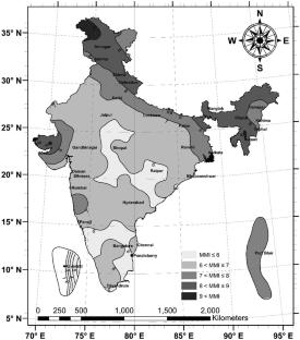
The probabilistic seismic hazard assessment (PSHA) incorporates probabilistic elements such as earthquake source, magnitude, distance, and spectral distribution. The approach has been widely used for developing hazard maps and zone maps considering Peak ground acceleration (PGA) as the intensity measure (IM). Conversely in India, earthquake intensity, which is crucial for measuring seismic events without instruments, has been the primary input for seismic zone maps in the past without including probabilistic rigor. PSHA-based zonation using PGA often overlooks spatial damage distribution, while MMI-based zonation without probabilistic approaches fails to account for seismic variability, source characteristics, and site effects. To address these limitations, this study introduces an intensity-based PSHA framework for the Indian subcontinent. Leveraging historical and contemporary intensity data, it enhances hazard assessments by accounting for past damage distribution and spatial variations in the built environment, producing hazard maps that align more closely with observed seismic impacts. A region-specific Intensity Prediction Model (IPM) for Modified Mercalli Intensity (MMI) is first developed using an artificial neural network (ANN) trained on a comprehensive intensity dataset. The Indian subcontinent is classified into four tectonic domains while developing IPM: (i) Himalayan Active Crustal Region, (ii) Indo-Gangetic Basin, (iii) Stable Continental or Indian Shield Region, and (iv) Indo-Myanmar and Andaman-Nicobar Subduction region. Utilizing this IPM, hazard assessment is conducted employing a logic-tree approach to address epistemic uncertainties, generating MMI-based hazard curves and maps. Intensity-based seismic zone maps are created using the natural break algorithm. A comparative analysis evaluates the effectiveness of MMI-based seismic zoning versus traditional PGA-based methods, demonstrating its potential for more accurate hazard characterization in India’s diverse tectonic settings. The findings suggest that rather than considering PGA- and MMI-based PSHA approaches as competing methods, a rational integration of both can lead to an improved seismic hazard characterization. PGA-based maps remain essential for engineering design and structural performance assessment, whereas MMI-based maps provide critical insights into spatial damage patterns, particularly in regions where historical intensity records are available. By leveraging the strengths of both approaches, a more holistic and reliable seismic zonation map can be developed to better account for regional tectonic variability and real-world earthquake impacts.
期刊介绍:
Bulletin of Earthquake Engineering presents original, peer-reviewed papers on research related to the broad spectrum of earthquake engineering. The journal offers a forum for presentation and discussion of such matters as European damaging earthquakes, new developments in earthquake regulations, and national policies applied after major seismic events, including strengthening of existing buildings.
Coverage includes seismic hazard studies and methods for mitigation of risk; earthquake source mechanism and strong motion characterization and their use for engineering applications; geological and geotechnical site conditions under earthquake excitations; cyclic behavior of soils; analysis and design of earth structures and foundations under seismic conditions; zonation and microzonation methodologies; earthquake scenarios and vulnerability assessments; earthquake codes and improvements, and much more.
This is the Official Publication of the European Association for Earthquake Engineering.
 求助内容:
求助内容: 应助结果提醒方式:


