重建过去的潮流:巴塔哥尼亚北部古潮汐的数值方法
IF 2.6
3区 地球科学
Q1 MARINE & FRESHWATER BIOLOGY
引用次数: 0
摘要
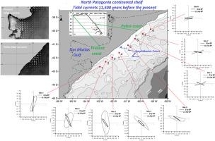
本研究提出了一个二维、深度平均的水动力模型,旨在模拟巴塔哥尼亚北部沿海地区距今11.5万年(11.5 14C kyr BP)左右的古潮汐条件,这大约对应于距今13万年(cal kyr BP)的校准,代表了圣Matías海湾洪水之前的情景。为了重建古水深,平均海平面相对于现在降低了50 m,并保持了潮汐势。该模式是由现今M2潮汐分量(该地区的主要成分)在开放边界处施加的强迫。结果表明,全新世晚期的潮流比现在强烈得多,特别是在圣Matías海湾出口的中央部分。模拟的水流方向与古海岸线方向一致,在41.5°S, 61.5°W附近的辐合/辐散带被解释为海岸古两栖点,潮汐波的旋转受到海岸线几何形状的限制。这项工作还解决了一个长期存在的问题,即海湾南部入口的淹没砾石沙丘的起源。模拟结果表明,现在的潮流不足以调动如此粗的沉积物,这表明这些特征是在不同的条件下形成的——可能是在海湾是一个干燥盆地被海平面上升淹没的过渡阶段。这些发现为该地区的古流体动力学提供了新的见解,并有助于理解与海平面变化有关的沉积过程。本文章由计算机程序翻译,如有差异,请以英文原文为准。
Reconstructing past tidal currents: A numerical approach to the paleotides of northern Patagonia
This study presents a two-dimensional, depth-averaged hydrodynamic model designed to simulate paleotidal conditions in the northern Patagonian coastal region around 11.5 radiocarbon thousand years before present (11.5 14C kyr BP), which corresponds approximately to 13 calibrated thousand years before present (cal kyr BP), representing a scenario prior to the flooding of San Matías Gulf. To reconstruct paleo-bathymetry, the mean sea level was lowered by 50 m relative to present conditions and the tidal-generating potential was maintained. The model is forced by present-day M2 tidal constituent—the dominant component in the area—applied at the open boundaries. Results reveal that tidal currents during the late Holocene were considerably more intense than today, particularly in the central sector of the San Matías Gulf outlet. The simulated flow directions align with the orientation of the ancient coastline, and a convergence/divergence zone identified near 41.5°S, 61.5°W is interpreted as a coastal paleo-amphidromic point, where tidal wave rotation was restricted by shoreline geometry. The work also addresses a long-standing question regarding the origin of submerged gravel dunes at the southern entrance of the gulf. Simulation results indicate that present-day tidal currents are insufficient to mobilize such coarse sediment, suggesting that these features formed under different conditions—possibly during a transitional phase when the gulf was a dry basin being flooded by rising sea level. These findings provide new insight into the paleo-hydrodynamics of the region and contribute to the understanding of sedimentary processes linked to sea-level changes.
求助全文
通过发布文献求助,成功后即可免费获取论文全文。
去求助
来源期刊
CiteScore
5.60
自引率
7.10%
发文量
374
审稿时长
9 months
期刊介绍:
Estuarine, Coastal and Shelf Science is an international multidisciplinary journal devoted to the analysis of saline water phenomena ranging from the outer edge of the continental shelf to the upper limits of the tidal zone. The journal provides a unique forum, unifying the multidisciplinary approaches to the study of the oceanography of estuaries, coastal zones, and continental shelf seas. It features original research papers, review papers and short communications treating such disciplines as zoology, botany, geology, sedimentology, physical oceanography.
 求助内容:
求助内容: 应助结果提醒方式:


