基于情景的综合方法评估产水量对土地利用和气候变化的响应
IF 5.6
Q1 ENVIRONMENTAL SCIENCES
引用次数: 0
摘要
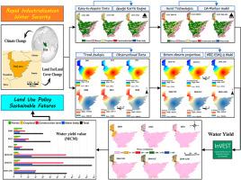
作为一项重要的生态系统服务(ES),水量的评估是至关重要的,因为它受人类活动的强烈影响。本研究以受土地利用/土地覆盖(LULC)和气候变化影响的伊朗塔詹流域(Mazandaran省)为研究对象。采用CA-Markov模型,基于三种情景对2040年中国土地利用储量进行了预测:1)自然发展(ND);ii)生态养护(欧共体);人为空间限制(ASR)。在SSP2-4.5情景下,使用MRI-ESM2-0模式预估了2024-2040年的气候变化评估。基于所研究的场景,实现了InVEST模型来计算WY。利用Landsat家庭影像编制的2000-2024年LULC地图显示,森林和荒地面积有所减少;相反,耕地、建设用地和水体增加了。在使用ND情景时,2040年也发现了类似的趋势。在EC情景中,农田(13.6%)和森林(11.5%)的变化最大。第三种情景表明,耕地和建设用地面积分别减少了6.5%和1.5%。这些变化直接影响到WY。例如,在过去24年中,它减少了667万立方米(MCM)。结果表明,在MCM中,ND的WY最高(54.99),其次是EC(53.35)和ASR(36.19)。这项研究突出了遥感在生态建模中的新应用,特别是在数据有限的地区。这也增强了我们对气候变化和LULC共同影响下的WY动态的认识。本文章由计算机程序翻译,如有差异,请以英文原文为准。
An integrated scenario-based approach for evaluating water yield responses to land use and climate change
The assessment of water yield (WY) as a key ecosystem service (ES) is crucial, as it is strongly influenced by anthropogenic activities. This study focuses on the Tajan Watershed (Mazandaran Province), Iran, a region affected by land use/land cover (LULC) and climate change. The CA-Markov model was used to predict LULC for 2040 based on three scenarios: i) Natural Development (ND); ii) Ecological Conservation (EC); and iii) Anthropogenic Space Restrictions (ASR). Climate change assessments for 2024–2040 were projected using the MRI-ESM2-0 model under the SSP2-4.5 scenario. The InVEST model was implemented to calculate WY based on the studied scenarios. The prepared LULC maps for 2000–2024 using Landsat family images showed that forest and barren areal extent have decreased; in contrast, cropland, construction land, and water bodies have increased. A similar trend was also found for 2040 when using the ND scenario. Regarding the EC scenario, the highest variation was observed for cropland (13.6 %) and forest (11.5 %). The third examined scenario demonstrated that cropland and construction land areas have declined by 6.5 % and 1.5 %, respectively. These changes directly impact WY. For instance, it has decreased by 6.67 million cubic meters (MCM) over the last 24 years. The results imply that the highest WY (in MCM) was for the scenarios of ND (54.99), followed by EC (53.35) and ASR (36.19). This research highlights the novel use of remote sensing in ecological modeling, particularly in data-limited areas. It also enhances our understanding of WY dynamics under the combined impacts of LULC and climate change.
求助全文
通过发布文献求助,成功后即可免费获取论文全文。
去求助
来源期刊

Environmental and Sustainability Indicators
Environmental Science-Environmental Science (miscellaneous)
CiteScore
7.80
自引率
2.30%
发文量
49
审稿时长
57 days
 求助内容:
求助内容: 应助结果提醒方式:


