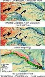
马里乌群岛的地貌景观:巴西亚马逊盆地内格罗河的一个分支大型复杂系统

IF 3.1 2区 地球科学 Q2 GEOGRAPHY, PHYSICAL
Matheus Silveira de Queiroz , Rogério Ribeiro Marinho , José Alberto Lima de Carvalho , Camila Fuziel Silva
{"title":"马里乌<e:1>群岛的地貌景观:巴西亚马逊盆地内格罗河的一个分支大型复杂系统","authors":"Matheus Silveira de Queiroz ,&nbsp;Rogério Ribeiro Marinho ,&nbsp;José Alberto Lima de Carvalho ,&nbsp;Camila Fuziel Silva","doi":"10.1016/j.geomorph.2025.110023","DOIUrl":null,"url":null,"abstract":"<div><div>The Negro River, the Amazon's principal left-bank tributary, exhibits a complex fluvial system of significant ecological and hydrogeomorphological importance. Its middle and lower reaches feature distinctive geomorphological landscapes, notably the Mariuá and Anavilhanas archipelagos, which serve as exemplary sites for investigating large anabranching rivers. This study examines the geomorphology of the Mariuá Archipelago through analysis of water dynamics, fluvial units, and sedimentary characteristics. We evaluated seasonal water level variations, erosion-transport-deposition processes, and grain-size distributions of islands and floodplains, complemented by comprehensive mapping of river units. Volumetric analysis reveals the fundamentally incomplete nature of the Mariuá floodplain, with the degree of incompleteness varying spatially from 30 % in upstream reaches to 60 % downstream, reflecting both temporal progression of filling and interruption of sediment input. The archipelago exemplifies an inherited fluvial landscape in permanent non-equilibrium, maintained by the Negro River's low suspended sediment concentration (3.2 × 10<sup>6</sup> ton.year<sup>−1</sup>) and limited stream power. Islands and floodplains comprise predominantly fine sediments (silt, clay, and very fine sand) stabilized by dense vegetation, while sandbars consist of medium to fine sand with occasional granule deposits. Although floodplains function as sediment traps through their levee-depression morphology, current sediment supply cannot explain the archipelago's formation. We propose that the Mariuá Archipelago originated from Japurá River sediments deposited when paleochannels connected these basins, with sediment supply ceasing abruptly around 1000 BP. While this inherited landscape has remained morphologically stable for centuries, recent analysis (2014–2024) reveals a 33 % increase in erosion and 83 % increase in deposition, suggesting the system may be approaching a stability threshold. Climate change and intensifying extreme hydrological events pose significant risks to this delicate equilibrium, potentially triggering irreversible morphological transformations in this unique Amazonian landscape.</div></div>","PeriodicalId":55115,"journal":{"name":"Geomorphology","volume":"490 ","pages":"Article 110023"},"PeriodicalIF":3.1000,"publicationDate":"2025-09-14","publicationTypes":"Journal Article","fieldsOfStudy":null,"isOpenAccess":false,"openAccessPdf":"","citationCount":"0","resultStr":"{\"title\":\"The geomorphological landscape of the Mariuá Archipelago: An anabranching megacomplex system in the Negro River, Amazon Basin (Brazil)\",\"authors\":\"Matheus Silveira de Queiroz ,&nbsp;Rogério Ribeiro Marinho ,&nbsp;José Alberto Lima de Carvalho ,&nbsp;Camila Fuziel Silva\",\"doi\":\"10.1016/j.geomorph.2025.110023\",\"DOIUrl\":null,\"url\":null,\"abstract\":\"<div><div>The Negro River, the Amazon's principal left-bank tributary, exhibits a complex fluvial system of significant ecological and hydrogeomorphological importance. Its middle and lower reaches feature distinctive geomorphological landscapes, notably the Mariuá and Anavilhanas archipelagos, which serve as exemplary sites for investigating large anabranching rivers. This study examines the geomorphology of the Mariuá Archipelago through analysis of water dynamics, fluvial units, and sedimentary characteristics. We evaluated seasonal water level variations, erosion-transport-deposition processes, and grain-size distributions of islands and floodplains, complemented by comprehensive mapping of river units. Volumetric analysis reveals the fundamentally incomplete nature of the Mariuá floodplain, with the degree of incompleteness varying spatially from 30 % in upstream reaches to 60 % downstream, reflecting both temporal progression of filling and interruption of sediment input. The archipelago exemplifies an inherited fluvial landscape in permanent non-equilibrium, maintained by the Negro River's low suspended sediment concentration (3.2 × 10<sup>6</sup> ton.year<sup>−1</sup>) and limited stream power. Islands and floodplains comprise predominantly fine sediments (silt, clay, and very fine sand) stabilized by dense vegetation, while sandbars consist of medium to fine sand with occasional granule deposits. Although floodplains function as sediment traps through their levee-depression morphology, current sediment supply cannot explain the archipelago's formation. We propose that the Mariuá Archipelago originated from Japurá River sediments deposited when paleochannels connected these basins, with sediment supply ceasing abruptly around 1000 BP. While this inherited landscape has remained morphologically stable for centuries, recent analysis (2014–2024) reveals a 33 % increase in erosion and 83 % increase in deposition, suggesting the system may be approaching a stability threshold. Climate change and intensifying extreme hydrological events pose significant risks to this delicate equilibrium, potentially triggering irreversible morphological transformations in this unique Amazonian landscape.</div></div>\",\"PeriodicalId\":55115,\"journal\":{\"name\":\"Geomorphology\",\"volume\":\"490 \",\"pages\":\"Article 110023\"},\"PeriodicalIF\":3.1000,\"publicationDate\":\"2025-09-14\",\"publicationTypes\":\"Journal Article\",\"fieldsOfStudy\":null,\"isOpenAccess\":false,\"openAccessPdf\":\"\",\"citationCount\":\"0\",\"resultStr\":null,\"platform\":\"Semanticscholar\",\"paperid\":null,\"PeriodicalName\":\"Geomorphology\",\"FirstCategoryId\":\"89\",\"ListUrlMain\":\"https://www.sciencedirect.com/science/article/pii/S0169555X25004337\",\"RegionNum\":2,\"RegionCategory\":\"地球科学\",\"ArticlePicture\":[],\"TitleCN\":null,\"AbstractTextCN\":null,\"PMCID\":null,\"EPubDate\":\"\",\"PubModel\":\"\",\"JCR\":\"Q2\",\"JCRName\":\"GEOGRAPHY, PHYSICAL\",\"Score\":null,\"Total\":0}","platform":"Semanticscholar","paperid":null,"PeriodicalName":"Geomorphology","FirstCategoryId":"89","ListUrlMain":"https://www.sciencedirect.com/science/article/pii/S0169555X25004337","RegionNum":2,"RegionCategory":"地球科学","ArticlePicture":[],"TitleCN":null,"AbstractTextCN":null,"PMCID":null,"EPubDate":"","PubModel":"","JCR":"Q2","JCRName":"GEOGRAPHY, PHYSICAL","Score":null,"Total":0}
引用次数: 0

摘要

内格罗河,亚马逊河的主要左岸支流,展示了一个具有重要生态和水文地貌重要性的复杂河流系统。它的中下游具有独特的地貌景观,特别是mariu和Anavilhanas群岛,它们是调查大型支流河流的典型地点。本研究通过对水动力学、河流单元和沉积特征的分析,考察了马里乌群岛的地貌。我们评估了季节水位变化、侵蚀-运输-沉积过程以及岛屿和洪泛平原的粒度分布,并辅以河流单元的综合制图。体积分析揭示了马里乌漫滩的基本不完全性,其不完全性在空间上从上游的30%到下游的60%不等,反映了充填的时间进展和泥沙输入的中断。由于内格罗河的低悬浮沉积物浓度(3.2 × 10⁶吨),该群岛体现了永久不平衡的继承河流景观。年份−1),限流功率。岛屿和洪泛平原主要由细沉积物(淤泥、粘土和非常细的沙子)组成,由茂密的植被稳定,而沙洲由中至细沙组成,偶尔有颗粒沉积物。虽然洪泛平原通过其堤防洼地的形态起到了沉积物陷阱的作用,但目前的沉积物供应并不能解释群岛的形成。我们认为马里乌群岛起源于古河道连接这些盆地时形成的日本河沉积物,沉积物供应在1000 BP左右突然停止。虽然这一继承的景观在形态上保持了几个世纪的稳定,但最近的分析(2014-2024)显示,侵蚀增加了33%,沉积增加了83%,这表明该系统可能正在接近稳定阈值。气候变化和不断加剧的极端水文事件对这种微妙的平衡构成了重大风险,可能在这一独特的亚马逊景观中引发不可逆转的形态转变。
本文章由计算机程序翻译,如有差异,请以英文原文为准。

The geomorphological landscape of the Mariuá Archipelago: An anabranching megacomplex system in the Negro River, Amazon Basin (Brazil)

The geomorphological landscape of the Mariuá Archipelago: An anabranching megacomplex system in the Negro River, Amazon Basin (Brazil)
The Negro River, the Amazon's principal left-bank tributary, exhibits a complex fluvial system of significant ecological and hydrogeomorphological importance. Its middle and lower reaches feature distinctive geomorphological landscapes, notably the Mariuá and Anavilhanas archipelagos, which serve as exemplary sites for investigating large anabranching rivers. This study examines the geomorphology of the Mariuá Archipelago through analysis of water dynamics, fluvial units, and sedimentary characteristics. We evaluated seasonal water level variations, erosion-transport-deposition processes, and grain-size distributions of islands and floodplains, complemented by comprehensive mapping of river units. Volumetric analysis reveals the fundamentally incomplete nature of the Mariuá floodplain, with the degree of incompleteness varying spatially from 30 % in upstream reaches to 60 % downstream, reflecting both temporal progression of filling and interruption of sediment input. The archipelago exemplifies an inherited fluvial landscape in permanent non-equilibrium, maintained by the Negro River's low suspended sediment concentration (3.2 × 106 ton.year−1) and limited stream power. Islands and floodplains comprise predominantly fine sediments (silt, clay, and very fine sand) stabilized by dense vegetation, while sandbars consist of medium to fine sand with occasional granule deposits. Although floodplains function as sediment traps through their levee-depression morphology, current sediment supply cannot explain the archipelago's formation. We propose that the Mariuá Archipelago originated from Japurá River sediments deposited when paleochannels connected these basins, with sediment supply ceasing abruptly around 1000 BP. While this inherited landscape has remained morphologically stable for centuries, recent analysis (2014–2024) reveals a 33 % increase in erosion and 83 % increase in deposition, suggesting the system may be approaching a stability threshold. Climate change and intensifying extreme hydrological events pose significant risks to this delicate equilibrium, potentially triggering irreversible morphological transformations in this unique Amazonian landscape.
求助全文
通过发布文献求助,成功后即可免费获取论文全文。 去求助
来源期刊
Geomorphology
Geomorphology 地学-地球科学综合
CiteScore
8.00
自引率
10.30%
发文量
309
审稿时长
3.4 months
期刊介绍: Our journal''s scope includes geomorphic themes of: tectonics and regional structure; glacial processes and landforms; fluvial sequences, Quaternary environmental change and dating; fluvial processes and landforms; mass movement, slopes and periglacial processes; hillslopes and soil erosion; weathering, karst and soils; aeolian processes and landforms, coastal dunes and arid environments; coastal and marine processes, estuaries and lakes; modelling, theoretical and quantitative geomorphology; DEM, GIS and remote sensing methods and applications; hazards, applied and planetary geomorphology; and volcanics.
×
引用
GB/T 7714-2015
复制
MLA
复制
APA
复制
导出至
BibTeX EndNote RefMan NoteFirst NoteExpress
×
提示
您的信息不完整,为了账户安全,请先补充。
现在去补充
×
提示
您因"违规操作"
具体请查看互助需知
我知道了
×
提示
确定
请完成安全验证×
copy
已复制链接
快去分享给好友吧!
我知道了
右上角分享
点击右上角分享
0
联系我们:info@booksci.cn Book学术提供免费学术资源搜索服务,方便国内外学者检索中英文文献。致力于提供最便捷和优质的服务体验。 Copyright © 2023 布克学术 All rights reserved.
京ICP备2023020795号-1
ghs 京公网安备 11010802042870号
Book学术文献互助
Book学术文献互助群
群 号:604180095
Book学术官方微信