{"title":"地球物理方法在土木工程研究中的应用综述","authors":"A.A. Akinlalu , M.M. Futai , D.O. Afolabi , R.M. Abraham-A","doi":"10.1016/j.geogeo.2025.100453","DOIUrl":null,"url":null,"abstract":"<div><div>This paper reviewed the application of geophysical methods in civil engineering projects by way of subsurface characterization by examining more than 75 publications in peer–reviewed journals. The paper highlighted various geological conditions considered in engineering site characterization and the appropriate geophysical methods such as electrical resistivity tomography, seismic refraction tomography, self-potential, induced polarization, electromagnetic, multichannel analysis of surface waves and magnetic methods used in subsurface characterization. Case studies drawn from 26 publications were presented to show the successful application of geophysical methods in subsurface characterization in relation to civil engineering projects. The paper also highlighted the challenges of geophysical data in civil engineering projects involving ambiguities in data interpretation, complexity in data processing and high noise to signal ratio in culturally noisy environments. Resolutions in the limitations and challenges of geophysical methods in civil engineering characterization were also offered in the paper, chief among them is integrated use of geophysical methods which has gained traction in recent years. Further solutions are incorporating appropriate band pass filters in the design of geophysical equipment’s to enhance signal to noise ratio in culturally noisy environments. Future researches in the use of geophysical methods in subsurface characterization in relation to civil engineering projects should involve joint inversion and modelling of integrated geophysical methods to achieve optimum results for subsurface imaging. Future researches should also incorporate the integration of machine learning and deep learning techniques, which enhance automated interpretation, facilitate anomaly detection, and enable real-time geophysical monitoring in civil infrastructure applications.</div></div>","PeriodicalId":100582,"journal":{"name":"Geosystems and Geoenvironment","volume":"5 1","pages":"Article 100453"},"PeriodicalIF":0.0000,"publicationDate":"2025-08-30","publicationTypes":"Journal Article","fieldsOfStudy":null,"isOpenAccess":false,"openAccessPdf":"","citationCount":"0","resultStr":"{\"title\":\"A review on the application of geophysical methods in civil engineering studies\",\"authors\":\"A.A. Akinlalu , M.M. Futai , D.O. Afolabi , R.M. Abraham-A\",\"doi\":\"10.1016/j.geogeo.2025.100453\",\"DOIUrl\":null,\"url\":null,\"abstract\":\"<div><div>This paper reviewed the application of geophysical methods in civil engineering projects by way of subsurface characterization by examining more than 75 publications in peer–reviewed journals. The paper highlighted various geological conditions considered in engineering site characterization and the appropriate geophysical methods such as electrical resistivity tomography, seismic refraction tomography, self-potential, induced polarization, electromagnetic, multichannel analysis of surface waves and magnetic methods used in subsurface characterization. Case studies drawn from 26 publications were presented to show the successful application of geophysical methods in subsurface characterization in relation to civil engineering projects. The paper also highlighted the challenges of geophysical data in civil engineering projects involving ambiguities in data interpretation, complexity in data processing and high noise to signal ratio in culturally noisy environments. Resolutions in the limitations and challenges of geophysical methods in civil engineering characterization were also offered in the paper, chief among them is integrated use of geophysical methods which has gained traction in recent years. Further solutions are incorporating appropriate band pass filters in the design of geophysical equipment’s to enhance signal to noise ratio in culturally noisy environments. Future researches in the use of geophysical methods in subsurface characterization in relation to civil engineering projects should involve joint inversion and modelling of integrated geophysical methods to achieve optimum results for subsurface imaging. Future researches should also incorporate the integration of machine learning and deep learning techniques, which enhance automated interpretation, facilitate anomaly detection, and enable real-time geophysical monitoring in civil infrastructure applications.</div></div>\",\"PeriodicalId\":100582,\"journal\":{\"name\":\"Geosystems and Geoenvironment\",\"volume\":\"5 1\",\"pages\":\"Article 100453\"},\"PeriodicalIF\":0.0000,\"publicationDate\":\"2025-08-30\",\"publicationTypes\":\"Journal Article\",\"fieldsOfStudy\":null,\"isOpenAccess\":false,\"openAccessPdf\":\"\",\"citationCount\":\"0\",\"resultStr\":null,\"platform\":\"Semanticscholar\",\"paperid\":null,\"PeriodicalName\":\"Geosystems and Geoenvironment\",\"FirstCategoryId\":\"1085\",\"ListUrlMain\":\"https://www.sciencedirect.com/science/article/pii/S2772883825001013\",\"RegionNum\":0,\"RegionCategory\":null,\"ArticlePicture\":[],\"TitleCN\":null,\"AbstractTextCN\":null,\"PMCID\":null,\"EPubDate\":\"\",\"PubModel\":\"\",\"JCR\":\"\",\"JCRName\":\"\",\"Score\":null,\"Total\":0}","platform":"Semanticscholar","paperid":null,"PeriodicalName":"Geosystems and Geoenvironment","FirstCategoryId":"1085","ListUrlMain":"https://www.sciencedirect.com/science/article/pii/S2772883825001013","RegionNum":0,"RegionCategory":null,"ArticlePicture":[],"TitleCN":null,"AbstractTextCN":null,"PMCID":null,"EPubDate":"","PubModel":"","JCR":"","JCRName":"","Score":null,"Total":0}
A review on the application of geophysical methods in civil engineering studies
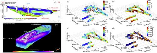
This paper reviewed the application of geophysical methods in civil engineering projects by way of subsurface characterization by examining more than 75 publications in peer–reviewed journals. The paper highlighted various geological conditions considered in engineering site characterization and the appropriate geophysical methods such as electrical resistivity tomography, seismic refraction tomography, self-potential, induced polarization, electromagnetic, multichannel analysis of surface waves and magnetic methods used in subsurface characterization. Case studies drawn from 26 publications were presented to show the successful application of geophysical methods in subsurface characterization in relation to civil engineering projects. The paper also highlighted the challenges of geophysical data in civil engineering projects involving ambiguities in data interpretation, complexity in data processing and high noise to signal ratio in culturally noisy environments. Resolutions in the limitations and challenges of geophysical methods in civil engineering characterization were also offered in the paper, chief among them is integrated use of geophysical methods which has gained traction in recent years. Further solutions are incorporating appropriate band pass filters in the design of geophysical equipment’s to enhance signal to noise ratio in culturally noisy environments. Future researches in the use of geophysical methods in subsurface characterization in relation to civil engineering projects should involve joint inversion and modelling of integrated geophysical methods to achieve optimum results for subsurface imaging. Future researches should also incorporate the integration of machine learning and deep learning techniques, which enhance automated interpretation, facilitate anomaly detection, and enable real-time geophysical monitoring in civil infrastructure applications.

 求助内容:
求助内容: 应助结果提醒方式:


