IF 3.1 2区 地球科学 Q2 GEOGRAPHY, PHYSICAL
Yuanling Li , Bin Yu , Hai Huang , Jiajia Zhang , You Tian , Bo Gao , Cheng Gong , Long Chen , Dongxu Yang , Qili Xie , Luxu Zhou
{"title":"A rock-ice avalanche induced complex hazard cascade in the Suku River basin, southeastern Tibetan Plateau","authors":"Yuanling Li ,&nbsp;Bin Yu ,&nbsp;Hai Huang ,&nbsp;Jiajia Zhang ,&nbsp;You Tian ,&nbsp;Bo Gao ,&nbsp;Cheng Gong ,&nbsp;Long Chen ,&nbsp;Dongxu Yang ,&nbsp;Qili Xie ,&nbsp;Luxu Zhou","doi":"10.1016/j.geomorph.2025.110000","DOIUrl":null,"url":null,"abstract":"<div><div>In the Tibetan Plateau cryosphere, rock and ice avalanches are becoming more frequent due to climate warming. These events often trigger a cascade effect, resulting in catastrophic disasters. On July 2, 2018, a rock-ice avalanche occurred in the Suku River basin on the southeastern Tibetan Plateau, triggering an extremely complex hazard cascade. This cascade included eight processes: rock and ice avalanche, mass flow, barrier lake, outburst flood, debris flow, flood, debris flow, flood. The event caused significant damage to infrastructure within approximately 50 km downstream, inundating and destroying dozens of houses and 150 m roads. The hazard cascade event was reconstructed using optical images, digital elevation model data, field investigation, and numerical analysis. The rock-ice avalanche originated in the steep glacial bedrock area at the top of the right bank of the Suku River, with a 3.60 million cubic meters volume. The fractured rock and ice hit the lower slope, disintegrated, transformed into mass flow, and scoured the lower glacier and moraine. Eventually, these mixed materials accumulated in the Suku River and formed a barrier dam with a height of 68 m. After three days, the dam lake overtopped and burst, with the entire process lasting approximately two hours and reaching a peak flow of 195.16 m<sup>3</sup>/s. Subsequently, the outburst fluid underwent multiple transitions between flood and debris flow due to the input and output of loose solid materials downstream. Meteorological data indicates that rapid warming and prolonged heavy rainfall triggered the rock and ice avalanche. After the rock and ice failure, the transformation process was primarily controlled by the topography and the erosion and deposition of loose materials downstream. This study is crucial for understanding the complex hazard cascade process of the cryosphere and for mitigating disaster risk.</div></div>","PeriodicalId":55115,"journal":{"name":"Geomorphology","volume":"489 ","pages":"Article 110000"},"PeriodicalIF":3.1000,"publicationDate":"2025-09-08","publicationTypes":"Journal Article","fieldsOfStudy":null,"isOpenAccess":false,"openAccessPdf":"","citationCount":"0","resultStr":null,"platform":"Semanticscholar","paperid":null,"PeriodicalName":"Geomorphology","FirstCategoryId":"89","ListUrlMain":"https://www.sciencedirect.com/science/article/pii/S0169555X25004106","RegionNum":2,"RegionCategory":"地球科学","ArticlePicture":[],"TitleCN":null,"AbstractTextCN":null,"PMCID":null,"EPubDate":"","PubModel":"","JCR":"Q2","JCRName":"GEOGRAPHY, PHYSICAL","Score":null,"Total":0}
引用次数: 0

摘要

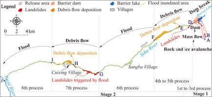
这些事件往往会引发级联效应,导致灾难性的灾难。该级联包括8个过程:岩冰崩、物质流、堰塞湖、溃决洪水、泥石流、洪水、泥石流、洪水。该事件对下游约50公里范围内的基础设施造成了严重破坏,淹没并摧毁了数十座房屋和150米长的道路。利用光学图像、数字高程模型数据、野外调查和数值分析,重建了灾害级联事件。此次岩冰雪崩发源于苏库河右岸顶部陡峭的冰川基岩区,体积360万立方米。破碎的岩石和冰撞击下斜坡,崩解,转化为块状流,冲刷下面的冰川和冰碛。最终,这些混合物质在苏库河中积聚,形成了一个68米高的屏障坝。3天后,堰塞湖发生决口,整个过程持续约2小时,最大流量达195.16 m3/s。随后,由于下游松散固体物质的输入和输出,溃决流体在洪水和泥石流之间经历了多次过渡。气象资料表明,迅速变暖和长时间的强降雨引发了岩石和冰崩。岩石和冰破坏后,转化过程主要受地形和下游松散物质的侵蚀和沉积控制。该研究对了解冰冻圈复杂的灾害级联过程和减轻灾害风险具有重要意义。
本文章由计算机程序翻译,如有差异,请以英文原文为准。

A rock-ice avalanche induced complex hazard cascade in the Suku River basin, southeastern Tibetan Plateau

A rock-ice avalanche induced complex hazard cascade in the Suku River basin, southeastern Tibetan Plateau
In the Tibetan Plateau cryosphere, rock and ice avalanches are becoming more frequent due to climate warming. These events often trigger a cascade effect, resulting in catastrophic disasters. On July 2, 2018, a rock-ice avalanche occurred in the Suku River basin on the southeastern Tibetan Plateau, triggering an extremely complex hazard cascade. This cascade included eight processes: rock and ice avalanche, mass flow, barrier lake, outburst flood, debris flow, flood, debris flow, flood. The event caused significant damage to infrastructure within approximately 50 km downstream, inundating and destroying dozens of houses and 150 m roads. The hazard cascade event was reconstructed using optical images, digital elevation model data, field investigation, and numerical analysis. The rock-ice avalanche originated in the steep glacial bedrock area at the top of the right bank of the Suku River, with a 3.60 million cubic meters volume. The fractured rock and ice hit the lower slope, disintegrated, transformed into mass flow, and scoured the lower glacier and moraine. Eventually, these mixed materials accumulated in the Suku River and formed a barrier dam with a height of 68 m. After three days, the dam lake overtopped and burst, with the entire process lasting approximately two hours and reaching a peak flow of 195.16 m3/s. Subsequently, the outburst fluid underwent multiple transitions between flood and debris flow due to the input and output of loose solid materials downstream. Meteorological data indicates that rapid warming and prolonged heavy rainfall triggered the rock and ice avalanche. After the rock and ice failure, the transformation process was primarily controlled by the topography and the erosion and deposition of loose materials downstream. This study is crucial for understanding the complex hazard cascade process of the cryosphere and for mitigating disaster risk.
求助全文
通过发布文献求助,成功后即可免费获取论文全文。 去求助
来源期刊
Geomorphology
Geomorphology 地学-地球科学综合
CiteScore
8.00
自引率
10.30%
发文量
309
审稿时长
3.4 months
期刊介绍: Our journal''s scope includes geomorphic themes of: tectonics and regional structure; glacial processes and landforms; fluvial sequences, Quaternary environmental change and dating; fluvial processes and landforms; mass movement, slopes and periglacial processes; hillslopes and soil erosion; weathering, karst and soils; aeolian processes and landforms, coastal dunes and arid environments; coastal and marine processes, estuaries and lakes; modelling, theoretical and quantitative geomorphology; DEM, GIS and remote sensing methods and applications; hazards, applied and planetary geomorphology; and volcanics.
×
引用
GB/T 7714-2015
复制
MLA
复制
APA
复制
导出至
BibTeX EndNote RefMan NoteFirst NoteExpress
×
提示
您的信息不完整,为了账户安全,请先补充。
现在去补充
×
提示
您因"违规操作"
具体请查看互助需知
我知道了
×
提示
确定
请完成安全验证×
copy
已复制链接
快去分享给好友吧!
我知道了
右上角分享
点击右上角分享
0
联系我们:info@booksci.cn Book学术提供免费学术资源搜索服务,方便国内外学者检索中英文文献。致力于提供最便捷和优质的服务体验。 Copyright © 2023 布克学术 All rights reserved.
京ICP备2023020795号-1
ghs 京公网安备 11010802042870号
Book学术文献互助
Book学术文献互助群
群 号:604180095
Book学术官方微信