量化五十年来沿越南中部富颜海岸的海岸线变化与河流泥沙供应的关系

IF 3.1 2区 地球科学 Q2 GEOGRAPHY, PHYSICAL
Quang Hao Nguyen , Le Thi Que , Tran Quoc Viet , Tien Dat Pham , Vinh Ngoc Tran , Nguyen Tien Giang , Phong Nguyen Thanh , Duong Tran Anh
{"title":"量化五十年来沿越南中部富颜海岸的海岸线变化与河流泥沙供应的关系","authors":"Quang Hao Nguyen ,&nbsp;Le Thi Que ,&nbsp;Tran Quoc Viet ,&nbsp;Tien Dat Pham ,&nbsp;Vinh Ngoc Tran ,&nbsp;Nguyen Tien Giang ,&nbsp;Phong Nguyen Thanh ,&nbsp;Duong Tran Anh","doi":"10.1016/j.geomorph.2025.110004","DOIUrl":null,"url":null,"abstract":"<div><div>We examined the relationship between shoreline dynamics and significant changes in river sediment supply along the Phu Yen Coast, a typical coastal area in central Vietnam, over a 53-year period (1972–2024). Empirical Orthogonal Functions (EOFs) were applied to a demeaned dataset to identify significant modes of shoreline position changes extracted from high-quality Landsat satellite data. Overall, we identified two distinct phases of coastal evolution: (i) a relatively stable period (1972–2012) characterized by modest accretion (+1 m/yr); (ii) followed by a period of shoreline retreat (2012–2024) at a rate of −1 m/yr. Notably, areas within 3 km of the river mouth, the shoreline exhibited severe geomorphic instability with retreat rates reaching −20 m/yr. Long-term monitoring of riverine processes in the Ba River system, the region's largest fluvial system, indicates a dramatic 82 % decline in river sediment discharge, from 2.17 × 10<sup>6</sup> ton/yr in 1979–2007 to 0.4 × 10<sup>6</sup> ton/yr in 2008–2023. Our EOF analysis showed that the first four modes explain up to 73 % of the observed shoreline variability, with primary controlling factors including riverine sediment supply fluctuations and both longshore and cross-shore transport processes. Significantly, we observed a multi-year lag between the reduction in river sediment supply and subsequent shoreline retreat, highlighting the complex temporal dynamics of coastal sediment budgets in response to anthropogenic perturbations.</div></div>","PeriodicalId":55115,"journal":{"name":"Geomorphology","volume":"489 ","pages":"Article 110004"},"PeriodicalIF":3.1000,"publicationDate":"2025-09-04","publicationTypes":"Journal Article","fieldsOfStudy":null,"isOpenAccess":false,"openAccessPdf":"","citationCount":"0","resultStr":"{\"title\":\"Quantifying five decades of shoreline change in relation to river sediment supply along the Phu Yen Coast, Central Vietnam\",\"authors\":\"Quang Hao Nguyen ,&nbsp;Le Thi Que ,&nbsp;Tran Quoc Viet ,&nbsp;Tien Dat Pham ,&nbsp;Vinh Ngoc Tran ,&nbsp;Nguyen Tien Giang ,&nbsp;Phong Nguyen Thanh ,&nbsp;Duong Tran Anh\",\"doi\":\"10.1016/j.geomorph.2025.110004\",\"DOIUrl\":null,\"url\":null,\"abstract\":\"<div><div>We examined the relationship between shoreline dynamics and significant changes in river sediment supply along the Phu Yen Coast, a typical coastal area in central Vietnam, over a 53-year period (1972–2024). Empirical Orthogonal Functions (EOFs) were applied to a demeaned dataset to identify significant modes of shoreline position changes extracted from high-quality Landsat satellite data. Overall, we identified two distinct phases of coastal evolution: (i) a relatively stable period (1972–2012) characterized by modest accretion (+1 m/yr); (ii) followed by a period of shoreline retreat (2012–2024) at a rate of −1 m/yr. Notably, areas within 3 km of the river mouth, the shoreline exhibited severe geomorphic instability with retreat rates reaching −20 m/yr. Long-term monitoring of riverine processes in the Ba River system, the region's largest fluvial system, indicates a dramatic 82 % decline in river sediment discharge, from 2.17 × 10<sup>6</sup> ton/yr in 1979–2007 to 0.4 × 10<sup>6</sup> ton/yr in 2008–2023. Our EOF analysis showed that the first four modes explain up to 73 % of the observed shoreline variability, with primary controlling factors including riverine sediment supply fluctuations and both longshore and cross-shore transport processes. Significantly, we observed a multi-year lag between the reduction in river sediment supply and subsequent shoreline retreat, highlighting the complex temporal dynamics of coastal sediment budgets in response to anthropogenic perturbations.</div></div>\",\"PeriodicalId\":55115,\"journal\":{\"name\":\"Geomorphology\",\"volume\":\"489 \",\"pages\":\"Article 110004\"},\"PeriodicalIF\":3.1000,\"publicationDate\":\"2025-09-04\",\"publicationTypes\":\"Journal Article\",\"fieldsOfStudy\":null,\"isOpenAccess\":false,\"openAccessPdf\":\"\",\"citationCount\":\"0\",\"resultStr\":null,\"platform\":\"Semanticscholar\",\"paperid\":null,\"PeriodicalName\":\"Geomorphology\",\"FirstCategoryId\":\"89\",\"ListUrlMain\":\"https://www.sciencedirect.com/science/article/pii/S0169555X25004143\",\"RegionNum\":2,\"RegionCategory\":\"地球科学\",\"ArticlePicture\":[],\"TitleCN\":null,\"AbstractTextCN\":null,\"PMCID\":null,\"EPubDate\":\"\",\"PubModel\":\"\",\"JCR\":\"Q2\",\"JCRName\":\"GEOGRAPHY, PHYSICAL\",\"Score\":null,\"Total\":0}","platform":"Semanticscholar","paperid":null,"PeriodicalName":"Geomorphology","FirstCategoryId":"89","ListUrlMain":"https://www.sciencedirect.com/science/article/pii/S0169555X25004143","RegionNum":2,"RegionCategory":"地球科学","ArticlePicture":[],"TitleCN":null,"AbstractTextCN":null,"PMCID":null,"EPubDate":"","PubModel":"","JCR":"Q2","JCRName":"GEOGRAPHY, PHYSICAL","Score":null,"Total":0}
引用次数: 0

摘要

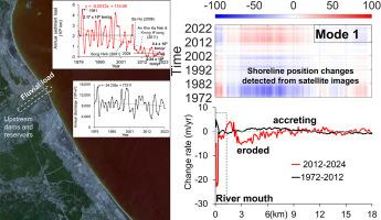
我们研究了53年期间(1972-2024)越南中部典型沿海地区富颜海岸的海岸线动态与河流沉积物供应显著变化之间的关系。利用经验正交函数(EOFs)对高质量Landsat卫星数据提取的海岸线位置变化数据集进行了特征识别。总体而言,我们确定了海岸演变的两个不同阶段:(i)相对稳定的时期(1972-2012),其特征是适度的增长(+1 m/年);(ii)随后是一段海岸线后退期(2012-2024年),后退速度为- 1米/年。值得注意的是,在河口3公里范围内,海岸线表现出严重的地貌不稳定性,退缩率达到- 20米/年。对该地区最大河流系统巴河水系河流过程的长期监测表明,河流输沙量急剧下降82%,从1979-2007年的2.17 × 106吨/年下降到2008-2023年的0.4 × 106吨/年。我们的EOF分析表明,前四种模式解释了高达73%的观测到的海岸线变化,主要控制因素包括河流泥沙供应波动和海岸和跨海岸运输过程。值得注意的是,我们观察到河流沉积物供应减少与随后的海岸线退缩之间存在多年滞后,突出了人为扰动对沿海沉积物收支的复杂时间动态响应。
本文章由计算机程序翻译,如有差异,请以英文原文为准。

Quantifying five decades of shoreline change in relation to river sediment supply along the Phu Yen Coast, Central Vietnam

Quantifying five decades of shoreline change in relation to river sediment supply along the Phu Yen Coast, Central Vietnam
We examined the relationship between shoreline dynamics and significant changes in river sediment supply along the Phu Yen Coast, a typical coastal area in central Vietnam, over a 53-year period (1972–2024). Empirical Orthogonal Functions (EOFs) were applied to a demeaned dataset to identify significant modes of shoreline position changes extracted from high-quality Landsat satellite data. Overall, we identified two distinct phases of coastal evolution: (i) a relatively stable period (1972–2012) characterized by modest accretion (+1 m/yr); (ii) followed by a period of shoreline retreat (2012–2024) at a rate of −1 m/yr. Notably, areas within 3 km of the river mouth, the shoreline exhibited severe geomorphic instability with retreat rates reaching −20 m/yr. Long-term monitoring of riverine processes in the Ba River system, the region's largest fluvial system, indicates a dramatic 82 % decline in river sediment discharge, from 2.17 × 106 ton/yr in 1979–2007 to 0.4 × 106 ton/yr in 2008–2023. Our EOF analysis showed that the first four modes explain up to 73 % of the observed shoreline variability, with primary controlling factors including riverine sediment supply fluctuations and both longshore and cross-shore transport processes. Significantly, we observed a multi-year lag between the reduction in river sediment supply and subsequent shoreline retreat, highlighting the complex temporal dynamics of coastal sediment budgets in response to anthropogenic perturbations.
求助全文
通过发布文献求助,成功后即可免费获取论文全文。 去求助
来源期刊
Geomorphology
Geomorphology 地学-地球科学综合
CiteScore
8.00
自引率
10.30%
发文量
309
审稿时长
3.4 months
期刊介绍: Our journal''s scope includes geomorphic themes of: tectonics and regional structure; glacial processes and landforms; fluvial sequences, Quaternary environmental change and dating; fluvial processes and landforms; mass movement, slopes and periglacial processes; hillslopes and soil erosion; weathering, karst and soils; aeolian processes and landforms, coastal dunes and arid environments; coastal and marine processes, estuaries and lakes; modelling, theoretical and quantitative geomorphology; DEM, GIS and remote sensing methods and applications; hazards, applied and planetary geomorphology; and volcanics.
×
引用
GB/T 7714-2015
复制
MLA
复制
APA
复制
导出至
BibTeX EndNote RefMan NoteFirst NoteExpress
×
提示
您的信息不完整,为了账户安全,请先补充。
现在去补充
×
提示
您因"违规操作"
具体请查看互助需知
我知道了
×
提示
确定
请完成安全验证×
copy
已复制链接
快去分享给好友吧!
我知道了
右上角分享
点击右上角分享
0
联系我们:info@booksci.cn Book学术提供免费学术资源搜索服务,方便国内外学者检索中英文文献。致力于提供最便捷和优质的服务体验。 Copyright © 2023 布克学术 All rights reserved.
京ICP备2023020795号-1
ghs 京公网安备 11010802042870号
Book学术文献互助
Book学术文献互助群
群 号:604180095
Book学术官方微信