{"title":"评估南非主要城市加油站的土地使用规定。","authors":"Kwanele Qonono, Wilfred Lunga","doi":"10.4102/jamba.v17i1.1898","DOIUrl":null,"url":null,"abstract":"<p><p>Noncompliance with locational guidelines for petrol station facilities in South Africa's urban areas is widespread, posing significant disaster risks. Petrol stations store and handle flammable substances such as liquefied petroleum gas, hydrogen and biodiesel, making adherence to environmental impact assessment (EIA) safety parameters critical. This study evaluates the spatial distribution and compliance of petrol stations in Johannesburg, Cape Town and Durban with the 2002 EIA guidelines. Using a mixed-methods approach, geospatial mapping via Google Earth and ArcGIS alongside secondary qualitative analysis, the study assessed petrol station distances from sensitive land uses (residential, public institutions and critical infrastructure) and the spacing between petrol stations. The results reveal a significant degree of noncompliance with the EIA's 100-m setback from sensitive uses and the 3-km minimum distance between petrol stations. In all three cities, petrol stations are often clustered within high-density urban cores, overlapping safety buffer zones and situated near residential and institutional structures. These spatial patterns indicate a regulatory gap in land-use enforcement and raise serious concerns about disaster preparedness and risk exposure in urban areas. The findings emphasise the urgent need to integrate disaster risk reduction (DRR) into urban land-use planning. While the study acknowledges that existing noncompliant petrol stations cannot be retrofitted easily, it recommends embedding DRR into future siting policies and calls for emergency preparedness measures at high-risk sites.</p><p><strong>Contribution: </strong>The study's spatially grounded analysis of EIA compliance across multiple cities in South Africa offers an evidence-based framework to guide future policy on hazardous facility siting in disaster-prone urban contexts.</p>","PeriodicalId":51823,"journal":{"name":"Jamba-Journal of Disaster Risk Studies","volume":"17 1","pages":"1898"},"PeriodicalIF":1.7000,"publicationDate":"2025-08-29","publicationTypes":"Journal Article","fieldsOfStudy":null,"isOpenAccess":false,"openAccessPdf":"https://www.ncbi.nlm.nih.gov/pmc/articles/PMC12421480/pdf/","citationCount":"0","resultStr":"{\"title\":\"Assessing land-use regulations for petrol stations in South Africa's major cities.\",\"authors\":\"Kwanele Qonono, Wilfred Lunga\",\"doi\":\"10.4102/jamba.v17i1.1898\",\"DOIUrl\":null,\"url\":null,\"abstract\":\"<p><p>Noncompliance with locational guidelines for petrol station facilities in South Africa's urban areas is widespread, posing significant disaster risks. Petrol stations store and handle flammable substances such as liquefied petroleum gas, hydrogen and biodiesel, making adherence to environmental impact assessment (EIA) safety parameters critical. This study evaluates the spatial distribution and compliance of petrol stations in Johannesburg, Cape Town and Durban with the 2002 EIA guidelines. Using a mixed-methods approach, geospatial mapping via Google Earth and ArcGIS alongside secondary qualitative analysis, the study assessed petrol station distances from sensitive land uses (residential, public institutions and critical infrastructure) and the spacing between petrol stations. The results reveal a significant degree of noncompliance with the EIA's 100-m setback from sensitive uses and the 3-km minimum distance between petrol stations. In all three cities, petrol stations are often clustered within high-density urban cores, overlapping safety buffer zones and situated near residential and institutional structures. These spatial patterns indicate a regulatory gap in land-use enforcement and raise serious concerns about disaster preparedness and risk exposure in urban areas. The findings emphasise the urgent need to integrate disaster risk reduction (DRR) into urban land-use planning. While the study acknowledges that existing noncompliant petrol stations cannot be retrofitted easily, it recommends embedding DRR into future siting policies and calls for emergency preparedness measures at high-risk sites.</p><p><strong>Contribution: </strong>The study's spatially grounded analysis of EIA compliance across multiple cities in South Africa offers an evidence-based framework to guide future policy on hazardous facility siting in disaster-prone urban contexts.</p>\",\"PeriodicalId\":51823,\"journal\":{\"name\":\"Jamba-Journal of Disaster Risk Studies\",\"volume\":\"17 1\",\"pages\":\"1898\"},\"PeriodicalIF\":1.7000,\"publicationDate\":\"2025-08-29\",\"publicationTypes\":\"Journal Article\",\"fieldsOfStudy\":null,\"isOpenAccess\":false,\"openAccessPdf\":\"https://www.ncbi.nlm.nih.gov/pmc/articles/PMC12421480/pdf/\",\"citationCount\":\"0\",\"resultStr\":null,\"platform\":\"Semanticscholar\",\"paperid\":null,\"PeriodicalName\":\"Jamba-Journal of Disaster Risk Studies\",\"FirstCategoryId\":\"1085\",\"ListUrlMain\":\"https://doi.org/10.4102/jamba.v17i1.1898\",\"RegionNum\":0,\"RegionCategory\":null,\"ArticlePicture\":[],\"TitleCN\":null,\"AbstractTextCN\":null,\"PMCID\":null,\"EPubDate\":\"2025/1/1 0:00:00\",\"PubModel\":\"eCollection\",\"JCR\":\"Q2\",\"JCRName\":\"SOCIAL SCIENCES, INTERDISCIPLINARY\",\"Score\":null,\"Total\":0}","platform":"Semanticscholar","paperid":null,"PeriodicalName":"Jamba-Journal of Disaster Risk Studies","FirstCategoryId":"1085","ListUrlMain":"https://doi.org/10.4102/jamba.v17i1.1898","RegionNum":0,"RegionCategory":null,"ArticlePicture":[],"TitleCN":null,"AbstractTextCN":null,"PMCID":null,"EPubDate":"2025/1/1 0:00:00","PubModel":"eCollection","JCR":"Q2","JCRName":"SOCIAL SCIENCES, INTERDISCIPLINARY","Score":null,"Total":0}
Assessing land-use regulations for petrol stations in South Africa's major cities.
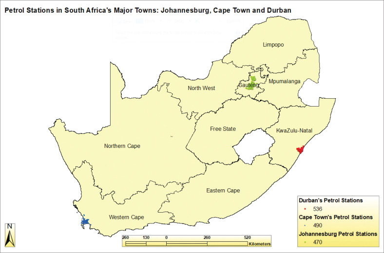
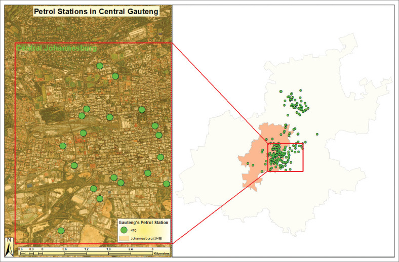
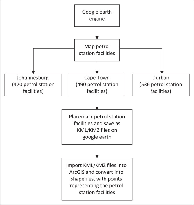
Noncompliance with locational guidelines for petrol station facilities in South Africa's urban areas is widespread, posing significant disaster risks. Petrol stations store and handle flammable substances such as liquefied petroleum gas, hydrogen and biodiesel, making adherence to environmental impact assessment (EIA) safety parameters critical. This study evaluates the spatial distribution and compliance of petrol stations in Johannesburg, Cape Town and Durban with the 2002 EIA guidelines. Using a mixed-methods approach, geospatial mapping via Google Earth and ArcGIS alongside secondary qualitative analysis, the study assessed petrol station distances from sensitive land uses (residential, public institutions and critical infrastructure) and the spacing between petrol stations. The results reveal a significant degree of noncompliance with the EIA's 100-m setback from sensitive uses and the 3-km minimum distance between petrol stations. In all three cities, petrol stations are often clustered within high-density urban cores, overlapping safety buffer zones and situated near residential and institutional structures. These spatial patterns indicate a regulatory gap in land-use enforcement and raise serious concerns about disaster preparedness and risk exposure in urban areas. The findings emphasise the urgent need to integrate disaster risk reduction (DRR) into urban land-use planning. While the study acknowledges that existing noncompliant petrol stations cannot be retrofitted easily, it recommends embedding DRR into future siting policies and calls for emergency preparedness measures at high-risk sites.
Contribution: The study's spatially grounded analysis of EIA compliance across multiple cities in South Africa offers an evidence-based framework to guide future policy on hazardous facility siting in disaster-prone urban contexts.

 求助内容:
求助内容: 应助结果提醒方式:


