S. V. Shvarev, S. B. Nikolaeva, I. V. Bondar, A. O. Koroleva, A. O. Komarov
{"title":"科拉半岛鲁文加冻土带Imandra-Kolvitsky断裂的形态构造与古地震震源带参数","authors":"S. V. Shvarev, S. B. Nikolaeva, I. V. Bondar, A. O. Koroleva, A. O. Komarov","doi":"10.3103/S0747923925700239","DOIUrl":null,"url":null,"abstract":"<p>Detailed paleoseismogeological studies have been carried out in the area of the Kandalaksha low-mountain massifs on the Kola Peninsula (northeast Fennoscandian Shield). In order to identify traces of paleoearthquakes, parametrization, and dating of events, a set of methods was used, including analysis of satellite images and digital elevation models (DEM), ground-based geological and geomorphological mapping, structural and tectonophysical studies, drilling of lakes in fault zones, and selection and radiocarbon (<sup>14</sup>C) dating of paleosols. The study of various groups of seismic disturbances in topography and rock massifs (seismotectonic, seismogravitational, seismovibrational), as well as morphotectonic data, allowed us to identify the large Imandra-Kolvitsky seismotectonic zone extending over 100 km in the southwest Kola Peninsula. As a result of the research, it was found that the zone inherited from the Precambrian showed activation in the Late Glacial and Holocene. The identified areas of seismic deformations, surveyed in the area of the Luvenga Tundra key site, allowed us to establish that there were epicenter zone of seismic fault, the intensity of which ranged from IX to VIII in the Late Glacial with a decrease in the Holocene. The seismic fault has a dextral strike-slip kinematics with a thrust component, implemented in the stress field of the meridional (NNE) maximum compression and wide-latitude (WNW) stretching. New data on estimating the age of paleoearthquakes indicate the four most likely events in the Holocene (ka cal BP): (1) ≈10.4; (2) ≈7.5; (3) ≈2.8–3.0; (4) ≈0.38. The conducted research can be used to develop scientific and methodological foundations for assessing the risks of catastrophic processes, updating earthquake catalogs and databases on active faults, as well as preventing seismic hazards of platform territories<b>.</b></p>","PeriodicalId":45174,"journal":{"name":"Seismic Instruments","volume":"61 1","pages":"25 - 47"},"PeriodicalIF":0.3000,"publicationDate":"2025-07-01","publicationTypes":"Journal Article","fieldsOfStudy":null,"isOpenAccess":false,"openAccessPdf":"","citationCount":"0","resultStr":"{\"title\":\"Morphotectonics of the Imandra–Kolvitsky Fault and Parameters of the Focal Zone of Paleoearthquakes in the Luvenga Tundra (Kola Peninsula)\",\"authors\":\"S. V. Shvarev, S. B. Nikolaeva, I. V. Bondar, A. O. Koroleva, A. O. Komarov\",\"doi\":\"10.3103/S0747923925700239\",\"DOIUrl\":null,\"url\":null,\"abstract\":\"<p>Detailed paleoseismogeological studies have been carried out in the area of the Kandalaksha low-mountain massifs on the Kola Peninsula (northeast Fennoscandian Shield). In order to identify traces of paleoearthquakes, parametrization, and dating of events, a set of methods was used, including analysis of satellite images and digital elevation models (DEM), ground-based geological and geomorphological mapping, structural and tectonophysical studies, drilling of lakes in fault zones, and selection and radiocarbon (<sup>14</sup>C) dating of paleosols. The study of various groups of seismic disturbances in topography and rock massifs (seismotectonic, seismogravitational, seismovibrational), as well as morphotectonic data, allowed us to identify the large Imandra-Kolvitsky seismotectonic zone extending over 100 km in the southwest Kola Peninsula. As a result of the research, it was found that the zone inherited from the Precambrian showed activation in the Late Glacial and Holocene. The identified areas of seismic deformations, surveyed in the area of the Luvenga Tundra key site, allowed us to establish that there were epicenter zone of seismic fault, the intensity of which ranged from IX to VIII in the Late Glacial with a decrease in the Holocene. The seismic fault has a dextral strike-slip kinematics with a thrust component, implemented in the stress field of the meridional (NNE) maximum compression and wide-latitude (WNW) stretching. New data on estimating the age of paleoearthquakes indicate the four most likely events in the Holocene (ka cal BP): (1) ≈10.4; (2) ≈7.5; (3) ≈2.8–3.0; (4) ≈0.38. The conducted research can be used to develop scientific and methodological foundations for assessing the risks of catastrophic processes, updating earthquake catalogs and databases on active faults, as well as preventing seismic hazards of platform territories<b>.</b></p>\",\"PeriodicalId\":45174,\"journal\":{\"name\":\"Seismic Instruments\",\"volume\":\"61 1\",\"pages\":\"25 - 47\"},\"PeriodicalIF\":0.3000,\"publicationDate\":\"2025-07-01\",\"publicationTypes\":\"Journal Article\",\"fieldsOfStudy\":null,\"isOpenAccess\":false,\"openAccessPdf\":\"\",\"citationCount\":\"0\",\"resultStr\":null,\"platform\":\"Semanticscholar\",\"paperid\":null,\"PeriodicalName\":\"Seismic Instruments\",\"FirstCategoryId\":\"1085\",\"ListUrlMain\":\"https://link.springer.com/article/10.3103/S0747923925700239\",\"RegionNum\":0,\"RegionCategory\":null,\"ArticlePicture\":[],\"TitleCN\":null,\"AbstractTextCN\":null,\"PMCID\":null,\"EPubDate\":\"\",\"PubModel\":\"\",\"JCR\":\"Q4\",\"JCRName\":\"GEOCHEMISTRY & GEOPHYSICS\",\"Score\":null,\"Total\":0}","platform":"Semanticscholar","paperid":null,"PeriodicalName":"Seismic Instruments","FirstCategoryId":"1085","ListUrlMain":"https://link.springer.com/article/10.3103/S0747923925700239","RegionNum":0,"RegionCategory":null,"ArticlePicture":[],"TitleCN":null,"AbstractTextCN":null,"PMCID":null,"EPubDate":"","PubModel":"","JCR":"Q4","JCRName":"GEOCHEMISTRY & GEOPHYSICS","Score":null,"Total":0}
引用次数: 0
摘要
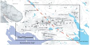
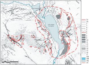
在科拉半岛(芬诺斯坎地盾东北部)坎大拉克沙低山地块进行了详细的古地震地质研究。为了识别古地震的痕迹、参数化和事件定年,采用了一系列方法,包括卫星图像和数字高程模型(DEM)分析、地面地质和地貌填图、构造和构造物理研究、断裂带湖泊钻探以及古土壤的选择和放射性碳(14C)定年。通过对地形和岩体中各种地震扰动(地震构造、地震重力、地震振动)以及形态构造数据的研究,我们确定了科拉半岛西南部延伸超过100公里的大型Imandra-Kolvitsky地震构造带。研究发现,前寒武纪继承带在晚冰期和全新世出现活化。通过对Luvenga冻土带重点遗址区地震变形区进行调查,确定了该地区存在地震断层震源带,地震断层震源带强度在晚冰期为9 ~ 8级,在全新世有所减弱。地震断层具有带逆冲分量的右向走滑运动学,实现在经向(NNE)最大压缩和宽纬度(WNW)拉伸的应力场中。新资料表明,全新世(ka cal BP)最可能发生的4次古地震:(1)≈10.4;(2)≈7.5;(3)≈2.8 - -3.0;(4)≈0.38。所进行的研究可用于开发评估灾难性过程风险的科学和方法基础,更新地震目录和活动断层数据库,以及防止平台区域的地震危害。
Morphotectonics of the Imandra–Kolvitsky Fault and Parameters of the Focal Zone of Paleoearthquakes in the Luvenga Tundra (Kola Peninsula)
Detailed paleoseismogeological studies have been carried out in the area of the Kandalaksha low-mountain massifs on the Kola Peninsula (northeast Fennoscandian Shield). In order to identify traces of paleoearthquakes, parametrization, and dating of events, a set of methods was used, including analysis of satellite images and digital elevation models (DEM), ground-based geological and geomorphological mapping, structural and tectonophysical studies, drilling of lakes in fault zones, and selection and radiocarbon (14C) dating of paleosols. The study of various groups of seismic disturbances in topography and rock massifs (seismotectonic, seismogravitational, seismovibrational), as well as morphotectonic data, allowed us to identify the large Imandra-Kolvitsky seismotectonic zone extending over 100 km in the southwest Kola Peninsula. As a result of the research, it was found that the zone inherited from the Precambrian showed activation in the Late Glacial and Holocene. The identified areas of seismic deformations, surveyed in the area of the Luvenga Tundra key site, allowed us to establish that there were epicenter zone of seismic fault, the intensity of which ranged from IX to VIII in the Late Glacial with a decrease in the Holocene. The seismic fault has a dextral strike-slip kinematics with a thrust component, implemented in the stress field of the meridional (NNE) maximum compression and wide-latitude (WNW) stretching. New data on estimating the age of paleoearthquakes indicate the four most likely events in the Holocene (ka cal BP): (1) ≈10.4; (2) ≈7.5; (3) ≈2.8–3.0; (4) ≈0.38. The conducted research can be used to develop scientific and methodological foundations for assessing the risks of catastrophic processes, updating earthquake catalogs and databases on active faults, as well as preventing seismic hazards of platform territories.
期刊介绍:
Seismic Instruments is a journal devoted to the description of geophysical instruments used in seismic research. In addition to covering the actual instruments for registering seismic waves, substantial room is devoted to solving instrumental-methodological problems of geophysical monitoring, applying various methods that are used to search for earthquake precursors, to studying earthquake nucleation processes and to monitoring natural and technogenous processes. The description of the construction, working elements, and technical characteristics of the instruments, as well as some results of implementation of the instruments and interpretation of the results are given. Attention is paid to seismic monitoring data and earthquake catalog quality Analysis.
 求助内容:
求助内容: 应助结果提醒方式:


