量化城市几何细节对城市空中交通风险预测的影响
IF 12
1区 工程技术
Q1 CONSTRUCTION & BUILDING TECHNOLOGY
引用次数: 0
摘要
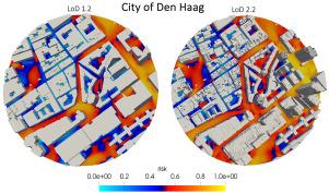
现实城市地区的风流预测对各种控制参数很敏感,如建筑分辨率、风入射、城市形态和底层地形等。在本研究中,我们使用专门为城市空中交通量身定制的Reynolds平均Navier-Stokes (RANS)计算框架,系统地研究了城市建筑环境的几何细节水平(LoD)的影响。使用1°的风入射角分辨率,我们对两个不同的城市区域进行了1440次模拟,并基于速度和湍流场开发了一个概率风险度量(Pr),使我们能够比较LoD 1.2(低几何细节)和LoD 2.2(高几何细节)的影响。对比风玫瑰加权平均风速和风险图,我们发现LoD 2.2对高风险地区的预测比LoD 1.2更为保守,这表明在适用的情况下需要采用更高的几何细节。我们的研究结果对低负荷的影响以及自动重建如何进一步提高当前风力工程实践的效率提出了警告性观点。本文章由计算机程序翻译,如有差异,请以英文原文为准。
Quantifying the impact of urban geometric detail for urban air mobility risk forecasting
Wind flow predictions in realistic urban areas are sensitive to a wide range of governing parameters such as building resolution, wind incidence, urban morphology, and underlying topography, to name a few. In this study, we systematically study the impact of the geometric level of detail (LoD) of the urban built environment using a Reynolds Averaged Navier–Stokes (RANS) computational framework specifically tailored for urban air mobility. Using a wind-incidence angular resolution of , we simulated a total of 1440 simulations for two distinct urban areas and developed a probabilistic risk metric () based on velocity and turbulence fields that allow us to compare the impact of LoD 1.2 (lower geometric detail) and LoD 2.2 (higher geometric detail). Comparing the wind-rose weighted average velocity and the risk map, we found that LoD 2.2 provides a more conservative prediction for high-risk areas than LoD 1.2, suggesting the need to adopt higher geometric details when applicable. Our results present a cautionary view on the impact of LoD and how automatic reconstruction can further the efficiency of current wind engineering practices.
求助全文
通过发布文献求助,成功后即可免费获取论文全文。
去求助
来源期刊

Sustainable Cities and Society
Social Sciences-Geography, Planning and Development
CiteScore
22.00
自引率
13.70%
发文量
810
审稿时长
27 days
期刊介绍:
Sustainable Cities and Society (SCS) is an international journal that focuses on fundamental and applied research to promote environmentally sustainable and socially resilient cities. The journal welcomes cross-cutting, multi-disciplinary research in various areas, including:
1. Smart cities and resilient environments;
2. Alternative/clean energy sources, energy distribution, distributed energy generation, and energy demand reduction/management;
3. Monitoring and improving air quality in built environment and cities (e.g., healthy built environment and air quality management);
4. Energy efficient, low/zero carbon, and green buildings/communities;
5. Climate change mitigation and adaptation in urban environments;
6. Green infrastructure and BMPs;
7. Environmental Footprint accounting and management;
8. Urban agriculture and forestry;
9. ICT, smart grid and intelligent infrastructure;
10. Urban design/planning, regulations, legislation, certification, economics, and policy;
11. Social aspects, impacts and resiliency of cities;
12. Behavior monitoring, analysis and change within urban communities;
13. Health monitoring and improvement;
14. Nexus issues related to sustainable cities and societies;
15. Smart city governance;
16. Decision Support Systems for trade-off and uncertainty analysis for improved management of cities and society;
17. Big data, machine learning, and artificial intelligence applications and case studies;
18. Critical infrastructure protection, including security, privacy, forensics, and reliability issues of cyber-physical systems.
19. Water footprint reduction and urban water distribution, harvesting, treatment, reuse and management;
20. Waste reduction and recycling;
21. Wastewater collection, treatment and recycling;
22. Smart, clean and healthy transportation systems and infrastructure;
 求助内容:
求助内容: 应助结果提醒方式:


