Dhaval R. Maru, Vijendra Kumar, Kul Vaibhav Sharma, Quoc Bao Pham, Anant Patel
{"title":"基于GIS、MCDM和空间分析的印度北阿坎德邦洪水风险综合评估与制图","authors":"Dhaval R. Maru, Vijendra Kumar, Kul Vaibhav Sharma, Quoc Bao Pham, Anant Patel","doi":"10.1002/gj.5172","DOIUrl":null,"url":null,"abstract":"<div>\n \n <p>This study presents a comprehensive approach to flood risk assessment and mapping in the Uttarakhand region, India, by integrating geographic information system (GIS) and multi-criteria decision-making (MCDM). The methodology involves using digital elevation models (DEMs) to categorise elevation into five classes, slope analysis to evaluate the role of terrain steepness and drainage density assessment to identify areas less susceptible to flooding. Average annual rainfall data, classified from meteorological stations, land use/land cover patterns and distances from rivers and roads, were analysed within a GIS framework to assess flood susceptibility. The analytic hierarchy process (AHP) was employed to assign weights to these criteria and generate a flood risk index (FRI) map. Key findings indicate that extensive moderate-to-high-risk zones are present, particularly in the lower regions of Uttarakhand. The weighted overlay analysis using GIS and AHP effectively identified areas at greater risk of flooding. The results offer valuable insights for flood risk management, land-use planning and disaster preparedness, highlighting the need for targeted interventions to enhance flood resilience in the region.</p>\n </div>","PeriodicalId":12784,"journal":{"name":"Geological Journal","volume":"60 9","pages":"2263-2280"},"PeriodicalIF":2.2000,"publicationDate":"2025-02-27","publicationTypes":"Journal Article","fieldsOfStudy":null,"isOpenAccess":false,"openAccessPdf":"","citationCount":"0","resultStr":"{\"title\":\"Integrating GIS, MCDM, and Spatial Analysis for Comprehensive Flood Risk Assessment and Mapping in Uttarakhand, India\",\"authors\":\"Dhaval R. Maru, Vijendra Kumar, Kul Vaibhav Sharma, Quoc Bao Pham, Anant Patel\",\"doi\":\"10.1002/gj.5172\",\"DOIUrl\":null,\"url\":null,\"abstract\":\"<div>\\n \\n <p>This study presents a comprehensive approach to flood risk assessment and mapping in the Uttarakhand region, India, by integrating geographic information system (GIS) and multi-criteria decision-making (MCDM). The methodology involves using digital elevation models (DEMs) to categorise elevation into five classes, slope analysis to evaluate the role of terrain steepness and drainage density assessment to identify areas less susceptible to flooding. Average annual rainfall data, classified from meteorological stations, land use/land cover patterns and distances from rivers and roads, were analysed within a GIS framework to assess flood susceptibility. The analytic hierarchy process (AHP) was employed to assign weights to these criteria and generate a flood risk index (FRI) map. Key findings indicate that extensive moderate-to-high-risk zones are present, particularly in the lower regions of Uttarakhand. The weighted overlay analysis using GIS and AHP effectively identified areas at greater risk of flooding. The results offer valuable insights for flood risk management, land-use planning and disaster preparedness, highlighting the need for targeted interventions to enhance flood resilience in the region.</p>\\n </div>\",\"PeriodicalId\":12784,\"journal\":{\"name\":\"Geological Journal\",\"volume\":\"60 9\",\"pages\":\"2263-2280\"},\"PeriodicalIF\":2.2000,\"publicationDate\":\"2025-02-27\",\"publicationTypes\":\"Journal Article\",\"fieldsOfStudy\":null,\"isOpenAccess\":false,\"openAccessPdf\":\"\",\"citationCount\":\"0\",\"resultStr\":null,\"platform\":\"Semanticscholar\",\"paperid\":null,\"PeriodicalName\":\"Geological Journal\",\"FirstCategoryId\":\"89\",\"ListUrlMain\":\"https://onlinelibrary.wiley.com/doi/10.1002/gj.5172\",\"RegionNum\":4,\"RegionCategory\":\"地球科学\",\"ArticlePicture\":[],\"TitleCN\":null,\"AbstractTextCN\":null,\"PMCID\":null,\"EPubDate\":\"\",\"PubModel\":\"\",\"JCR\":\"Q3\",\"JCRName\":\"GEOSCIENCES, MULTIDISCIPLINARY\",\"Score\":null,\"Total\":0}","platform":"Semanticscholar","paperid":null,"PeriodicalName":"Geological Journal","FirstCategoryId":"89","ListUrlMain":"https://onlinelibrary.wiley.com/doi/10.1002/gj.5172","RegionNum":4,"RegionCategory":"地球科学","ArticlePicture":[],"TitleCN":null,"AbstractTextCN":null,"PMCID":null,"EPubDate":"","PubModel":"","JCR":"Q3","JCRName":"GEOSCIENCES, MULTIDISCIPLINARY","Score":null,"Total":0}
Integrating GIS, MCDM, and Spatial Analysis for Comprehensive Flood Risk Assessment and Mapping in Uttarakhand, India
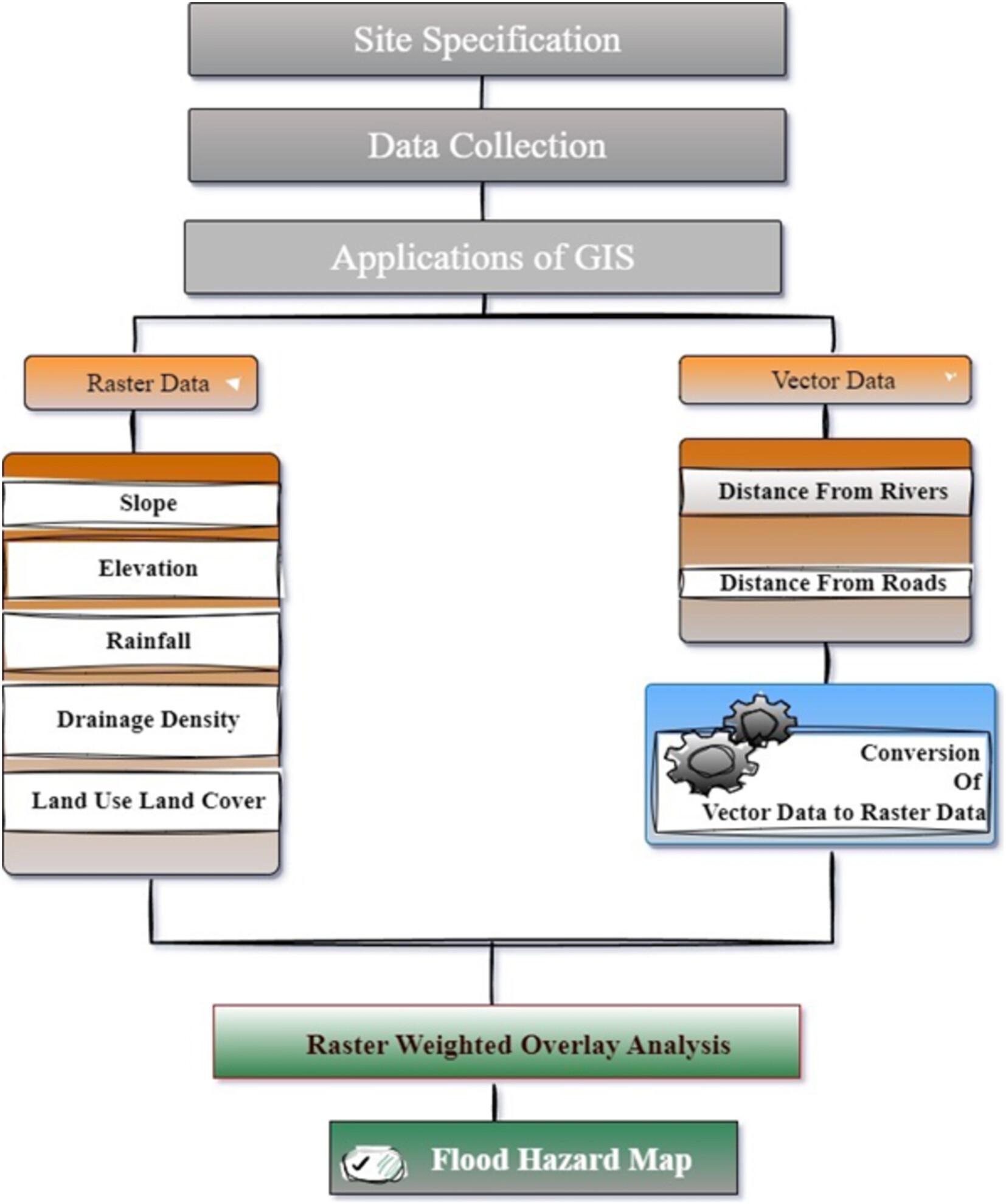
This study presents a comprehensive approach to flood risk assessment and mapping in the Uttarakhand region, India, by integrating geographic information system (GIS) and multi-criteria decision-making (MCDM). The methodology involves using digital elevation models (DEMs) to categorise elevation into five classes, slope analysis to evaluate the role of terrain steepness and drainage density assessment to identify areas less susceptible to flooding. Average annual rainfall data, classified from meteorological stations, land use/land cover patterns and distances from rivers and roads, were analysed within a GIS framework to assess flood susceptibility. The analytic hierarchy process (AHP) was employed to assign weights to these criteria and generate a flood risk index (FRI) map. Key findings indicate that extensive moderate-to-high-risk zones are present, particularly in the lower regions of Uttarakhand. The weighted overlay analysis using GIS and AHP effectively identified areas at greater risk of flooding. The results offer valuable insights for flood risk management, land-use planning and disaster preparedness, highlighting the need for targeted interventions to enhance flood resilience in the region.
期刊介绍:
In recent years there has been a growth of specialist journals within geological sciences. Nevertheless, there is an important role for a journal of an interdisciplinary kind. Traditionally, GEOLOGICAL JOURNAL has been such a journal and continues in its aim of promoting interest in all branches of the Geological Sciences, through publication of original research papers and review articles. The journal publishes Special Issues with a common theme or regional coverage e.g. Chinese Dinosaurs; Tectonics of the Eastern Mediterranean, Triassic basins of the Central and North Atlantic Borderlands). These are extensively cited.
The Journal has a particular interest in publishing papers on regional case studies from any global locality which have conclusions of general interest. Such papers may emphasize aspects across the full spectrum of geological sciences.
 求助内容:
求助内容: 应助结果提醒方式:


