{"title":"不同湿地景观的水文同步与功能冗余","authors":"Joshua M. Epstein, Matthew J. Cohen","doi":"10.1002/hyp.70244","DOIUrl":null,"url":null,"abstract":"<div>\n \n <p>Variation in the timing, duration, and synchrony of wetland inundation and hydrologic connectivity influences aggregate hydrologic, biogeochemical, and habitat functions of wetlandscapes (i.e., complexes of distinct wetlands embedded in uplands). To quantify and predict the redundancy of hydrological functions amongst wetlands, we measured hydrologic synchrony in three Florida wetlandscapes with contrasting morphology and connectivity patterns. Combining high frequency stage from multiple wetlands (<i>n</i> = 14–15) in each wetlandscape with LiDAR-derived topography, we measured synchrony based on wetland stage correlation and daily alignment of inundation (i.e., wet vs. dry) and surface connectivity (i.e., connected vs. disconnected) patterns. We evaluated how flowpath membership or position, wetland size, depth, and distance impacted synchrony patterns. We further evaluated whether assuming a spatially uniform planar water table across the wetlandscapes, implying perfect water level synchrony, accurately represented observed patterns. Observed synchrony was nearly perfect in the least topographically heterogeneous wetlandscape, where surface connectivity was frequent and prolonged, supporting the assumption of a spatially uniform water table. Wetland size, distance, and depth predicted synchrony, and variation in wetland hydrological function was negligible and fully attributed to topographic heterogeneity. In contrast, hydrological synchrony was lower where wetlandscape topographic heterogeneity was highest, and surface water connectivity was rare and brief. Here, flowpath membership was a significant predictor of synchrony. Hydrological redundancy of wetlands varies markedly across wetlandscapes, with aggregate landscape function degraded in proportion to wetland area loss when synchrony is high, but degraded more rapidly than the loss of area where hydrologic synchrony, and therefore redundancy, is low. With ongoing wetland losses nationally and globally, synchrony assessments inform efforts to evaluate and predict wetlandscape resilience to loss of wetland function and prioritise conservation of non-redundant wetlands to ensure the full continuum of wetlandscape structure is maintained.</p>\n </div>","PeriodicalId":13189,"journal":{"name":"Hydrological Processes","volume":"39 9","pages":""},"PeriodicalIF":2.9000,"publicationDate":"2025-09-07","publicationTypes":"Journal Article","fieldsOfStudy":null,"isOpenAccess":false,"openAccessPdf":"","citationCount":"0","resultStr":"{\"title\":\"Wetland Hydrologic Synchrony and Functional Redundancy Across Contrasting Wetlandscapes\",\"authors\":\"Joshua M. Epstein, Matthew J. Cohen\",\"doi\":\"10.1002/hyp.70244\",\"DOIUrl\":null,\"url\":null,\"abstract\":\"<div>\\n \\n <p>Variation in the timing, duration, and synchrony of wetland inundation and hydrologic connectivity influences aggregate hydrologic, biogeochemical, and habitat functions of wetlandscapes (i.e., complexes of distinct wetlands embedded in uplands). To quantify and predict the redundancy of hydrological functions amongst wetlands, we measured hydrologic synchrony in three Florida wetlandscapes with contrasting morphology and connectivity patterns. Combining high frequency stage from multiple wetlands (<i>n</i> = 14–15) in each wetlandscape with LiDAR-derived topography, we measured synchrony based on wetland stage correlation and daily alignment of inundation (i.e., wet vs. dry) and surface connectivity (i.e., connected vs. disconnected) patterns. We evaluated how flowpath membership or position, wetland size, depth, and distance impacted synchrony patterns. We further evaluated whether assuming a spatially uniform planar water table across the wetlandscapes, implying perfect water level synchrony, accurately represented observed patterns. Observed synchrony was nearly perfect in the least topographically heterogeneous wetlandscape, where surface connectivity was frequent and prolonged, supporting the assumption of a spatially uniform water table. Wetland size, distance, and depth predicted synchrony, and variation in wetland hydrological function was negligible and fully attributed to topographic heterogeneity. In contrast, hydrological synchrony was lower where wetlandscape topographic heterogeneity was highest, and surface water connectivity was rare and brief. Here, flowpath membership was a significant predictor of synchrony. Hydrological redundancy of wetlands varies markedly across wetlandscapes, with aggregate landscape function degraded in proportion to wetland area loss when synchrony is high, but degraded more rapidly than the loss of area where hydrologic synchrony, and therefore redundancy, is low. With ongoing wetland losses nationally and globally, synchrony assessments inform efforts to evaluate and predict wetlandscape resilience to loss of wetland function and prioritise conservation of non-redundant wetlands to ensure the full continuum of wetlandscape structure is maintained.</p>\\n </div>\",\"PeriodicalId\":13189,\"journal\":{\"name\":\"Hydrological Processes\",\"volume\":\"39 9\",\"pages\":\"\"},\"PeriodicalIF\":2.9000,\"publicationDate\":\"2025-09-07\",\"publicationTypes\":\"Journal Article\",\"fieldsOfStudy\":null,\"isOpenAccess\":false,\"openAccessPdf\":\"\",\"citationCount\":\"0\",\"resultStr\":null,\"platform\":\"Semanticscholar\",\"paperid\":null,\"PeriodicalName\":\"Hydrological Processes\",\"FirstCategoryId\":\"89\",\"ListUrlMain\":\"https://onlinelibrary.wiley.com/doi/10.1002/hyp.70244\",\"RegionNum\":3,\"RegionCategory\":\"地球科学\",\"ArticlePicture\":[],\"TitleCN\":null,\"AbstractTextCN\":null,\"PMCID\":null,\"EPubDate\":\"\",\"PubModel\":\"\",\"JCR\":\"Q1\",\"JCRName\":\"Environmental Science\",\"Score\":null,\"Total\":0}","platform":"Semanticscholar","paperid":null,"PeriodicalName":"Hydrological Processes","FirstCategoryId":"89","ListUrlMain":"https://onlinelibrary.wiley.com/doi/10.1002/hyp.70244","RegionNum":3,"RegionCategory":"地球科学","ArticlePicture":[],"TitleCN":null,"AbstractTextCN":null,"PMCID":null,"EPubDate":"","PubModel":"","JCR":"Q1","JCRName":"Environmental Science","Score":null,"Total":0}
Wetland Hydrologic Synchrony and Functional Redundancy Across Contrasting Wetlandscapes
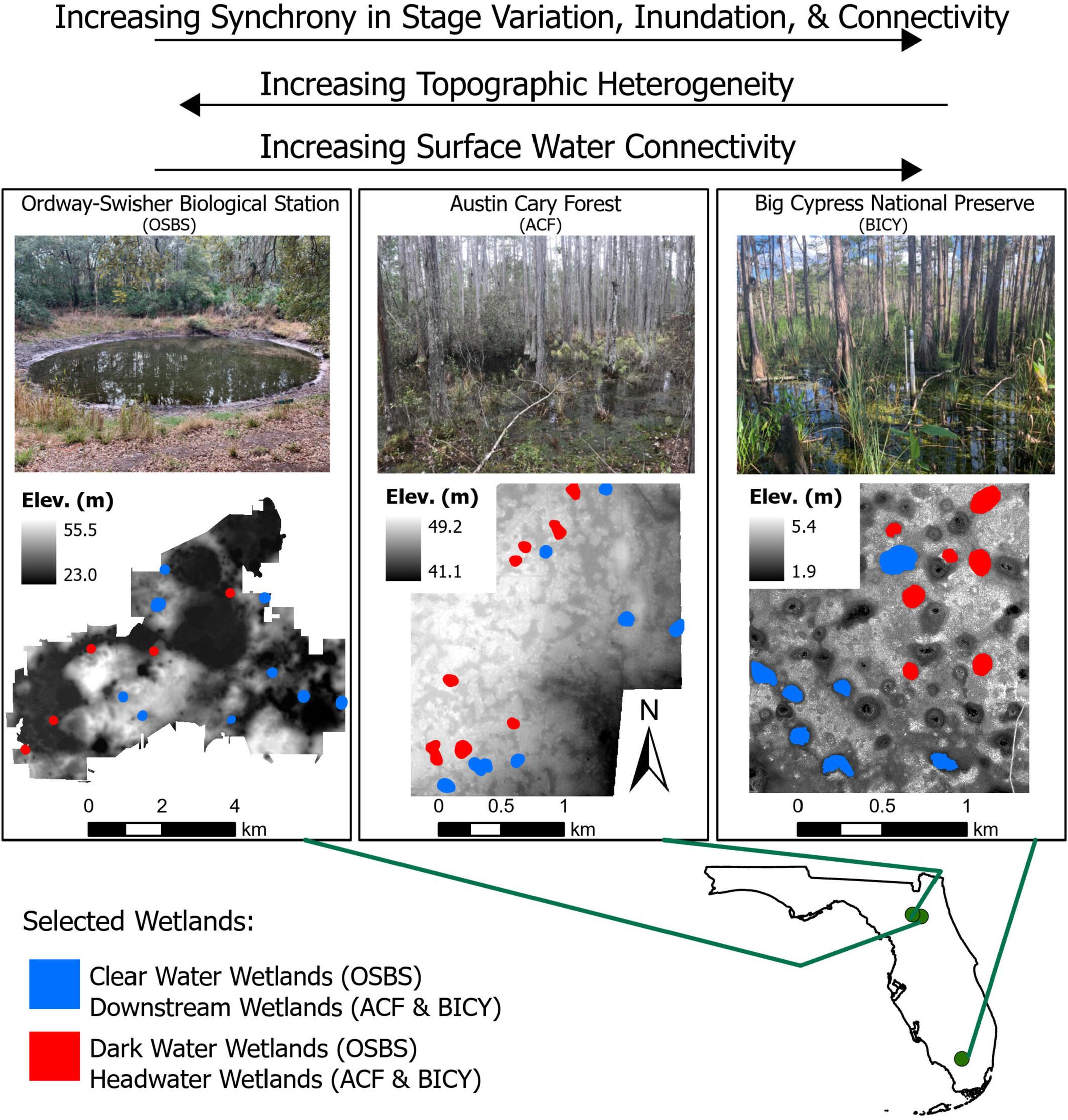
Variation in the timing, duration, and synchrony of wetland inundation and hydrologic connectivity influences aggregate hydrologic, biogeochemical, and habitat functions of wetlandscapes (i.e., complexes of distinct wetlands embedded in uplands). To quantify and predict the redundancy of hydrological functions amongst wetlands, we measured hydrologic synchrony in three Florida wetlandscapes with contrasting morphology and connectivity patterns. Combining high frequency stage from multiple wetlands (n = 14–15) in each wetlandscape with LiDAR-derived topography, we measured synchrony based on wetland stage correlation and daily alignment of inundation (i.e., wet vs. dry) and surface connectivity (i.e., connected vs. disconnected) patterns. We evaluated how flowpath membership or position, wetland size, depth, and distance impacted synchrony patterns. We further evaluated whether assuming a spatially uniform planar water table across the wetlandscapes, implying perfect water level synchrony, accurately represented observed patterns. Observed synchrony was nearly perfect in the least topographically heterogeneous wetlandscape, where surface connectivity was frequent and prolonged, supporting the assumption of a spatially uniform water table. Wetland size, distance, and depth predicted synchrony, and variation in wetland hydrological function was negligible and fully attributed to topographic heterogeneity. In contrast, hydrological synchrony was lower where wetlandscape topographic heterogeneity was highest, and surface water connectivity was rare and brief. Here, flowpath membership was a significant predictor of synchrony. Hydrological redundancy of wetlands varies markedly across wetlandscapes, with aggregate landscape function degraded in proportion to wetland area loss when synchrony is high, but degraded more rapidly than the loss of area where hydrologic synchrony, and therefore redundancy, is low. With ongoing wetland losses nationally and globally, synchrony assessments inform efforts to evaluate and predict wetlandscape resilience to loss of wetland function and prioritise conservation of non-redundant wetlands to ensure the full continuum of wetlandscape structure is maintained.
期刊介绍:
Hydrological Processes is an international journal that publishes original scientific papers advancing understanding of the mechanisms underlying the movement and storage of water in the environment, and the interaction of water with geological, biogeochemical, atmospheric and ecological systems. Not all papers related to water resources are appropriate for submission to this journal; rather we seek papers that clearly articulate the role(s) of hydrological processes.

 求助内容:
求助内容: 应助结果提醒方式:


