基于空间分布特征的基于XGBoost和SHAP的可解释人工智能(XAI)框架评估城市火灾风险
IF 4.5
1区 地球科学
Q1 GEOSCIENCES, MULTIDISCIPLINARY
International journal of disaster risk reduction
Pub Date : 2025-09-03
DOI:10.1016/j.ijdrr.2025.105798
引用次数: 0
摘要
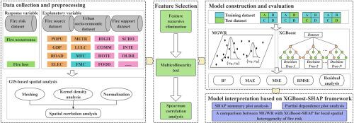
城市化的快速发展、人口密度的增加和基础设施的集中加剧了城市火灾风险。传统的火灾风险评估模型,如多尺度地理加权回归(MGWR),往往忽视了空间异质性,缺乏可解释性。本研究采用可解释人工智能(XAI)框架,结合极端梯度增强(XGBoost)和SHapley加性解释(SHAP)分别进行预测建模和特征归因,对成都市庆阳区的城市火灾风险进行了评估。一个关键的挑战是解决火灾风险的空间复杂性,并确保决策者的模型可解释性。为了克服这一挑战,我们将空间自相关度量和核密度分析相结合,分析了关键特征的空间格局。该框架在预测精度上优于MGWR,火灾发生和火灾损失的R2分别为0.998和0.935,而MGWR分别为0.995和0.856。火灾发生和火灾损失的均方误差分别为4.447和0.00027,MGWR的均方误差分别为10.297和0.00055。值得注意的是,SHAP值可以有效地解释城市火灾风险特征的空间异质性。本研究的主要贡献如下:(1)整合XGBoost和SHAP进行可解释的城市火灾风险预测;(2)应用空间分析提高模型透明度;(3)开发一个框架,为城市安全规划提供可操作的、空间明确的见解。本研究为政策制定者提供了一个数据驱动的工具,为城市火灾风险缓解提供了定量指导。本文章由计算机程序翻译,如有差异,请以英文原文为准。
Explainable Artificial Intelligence (XAI) framework using XGBoost and SHAP for assessing urban fire risk based on spatial distribution features
Urban fire risks intensify owing to rapid urbanization, increasing population density, and concentrated infrastructure. Traditional fire risk assessment models, such as Multi-scale Geographically Weighted Regression (MGWR), often overlook spatial heterogeneity and lack interpretability. This study applied an eXplainable Artificial Intelligence (XAI) framework integrating eXtreme Gradient Boosting (XGBoost) and SHapley Additive exPlanations (SHAP) for predictive modeling and for feature attribution, respectively, to assess the urban fire risk in Qingyang District in Chengdu, China. A key challenge was to address the spatial complexity of fire risks and ensure model interpretability for decision-makers. To overcome this challenge, we integrated spatial autocorrelation metrics and kernel density analysis to analyze the spatial patterns of key features. The framework outperformed MGWR in terms of prediction accuracy, with R2 values of 0.998 for fire occurrence and 0.935 for fire loss, compared to the 0.995 and 0.856 obtained for MGWR, respectively. The mean squared error was 4.447 for fire occurrence and 0.00027 for fire loss, while 10.297 and 0.00055 were obtained for MGWR, respectively. Notably, the SHAP values proved to be effective in explaining the spatial heterogeneity of urban fire risk features. The main contributions of this study are as follows: (1) the integration of XGBoost and SHAP for interpretable urban fire risk prediction, (2) the application of spatial analysis to enhance model transparency, and (3) the development of a framework that provides actionable, spatially explicit insights for urban safety planning. This study provides a data-driven tool for policymakers that offers quantitative guidance for urban fire risk mitigation.
求助全文
通过发布文献求助,成功后即可免费获取论文全文。
去求助
来源期刊

International journal of disaster risk reduction
GEOSCIENCES, MULTIDISCIPLINARYMETEOROLOGY-METEOROLOGY & ATMOSPHERIC SCIENCES
CiteScore
8.70
自引率
18.00%
发文量
688
审稿时长
79 days
期刊介绍:
The International Journal of Disaster Risk Reduction (IJDRR) is the journal for researchers, policymakers and practitioners across diverse disciplines: earth sciences and their implications; environmental sciences; engineering; urban studies; geography; and the social sciences. IJDRR publishes fundamental and applied research, critical reviews, policy papers and case studies with a particular focus on multi-disciplinary research that aims to reduce the impact of natural, technological, social and intentional disasters. IJDRR stimulates exchange of ideas and knowledge transfer on disaster research, mitigation, adaptation, prevention and risk reduction at all geographical scales: local, national and international.
Key topics:-
-multifaceted disaster and cascading disasters
-the development of disaster risk reduction strategies and techniques
-discussion and development of effective warning and educational systems for risk management at all levels
-disasters associated with climate change
-vulnerability analysis and vulnerability trends
-emerging risks
-resilience against disasters.
The journal particularly encourages papers that approach risk from a multi-disciplinary perspective.
 求助内容:
求助内容: 应助结果提醒方式:


