{"title":"基于gis的埃塞俄比亚北部Gedo-Dilb沥青公路滑坡易感性制图","authors":"Solomon Wendim, Gebreslassie Mebrahtu, Kifle Woldearegay","doi":"10.1007/s10064-025-04455-0","DOIUrl":null,"url":null,"abstract":"<div><p>Landslide hazards are common problems in the rift escarpments and highlands of Ethiopia, causing damage to infrastructures, agricultural lands, and human lives. The Gedo-Dilb asphalt road, which crosses the western rift escarpments of northern Ethiopia, is frequently affected by landslides. The study aims to analyze spatial distributions of landslides and generate a landslide susceptibility map (LSM). The research work involved: (a) detailed inventory and characterization of landslides, and (b) evaluation of the landslides and their associations with different causative factors. Landslide inventory of the area was produced using Google Earth imagery, aerial photos, and intensive field campaigns. Accordingly, a total of 103 landslides were inventoried, encompassing an area of 8.44 km<sup>2</sup>. The main landslide types found in the area are rockfalls, debris/earth flows, and debris/earth slides. Seven causative factors were identified and used for landslide susceptibility mapping, namely: distance to stream, slope gradient, distance to road, land use land cover, lithology, plan and profile curvatures. Analytical hierarchy process (AHP) approach was used, and the model was validated using the area under the receiver operating characteristic (ROC) curve. The area under the curve (AUC) value was found to be 0.8198, indicating very good prediction of landslide susceptibility in the study area. It was observed that 75.12% of the inventoried landslides fall in the high and very high susceptibility zones. The AHP weight result revealed that slope gradient, lithology, and distance to stream played a major role in landslide occurrences. The resulting map would be important for regional spatial planning and future infrastructure development.</p></div>","PeriodicalId":500,"journal":{"name":"Bulletin of Engineering Geology and the Environment","volume":"84 10","pages":""},"PeriodicalIF":4.2000,"publicationDate":"2025-09-05","publicationTypes":"Journal Article","fieldsOfStudy":null,"isOpenAccess":false,"openAccessPdf":"","citationCount":"0","resultStr":"{\"title\":\"GIS-based landslide susceptibility mapping using Analytical Hierarchy Process method along Gedo-Dilb asphalt road section, Northern Ethiopia\",\"authors\":\"Solomon Wendim, Gebreslassie Mebrahtu, Kifle Woldearegay\",\"doi\":\"10.1007/s10064-025-04455-0\",\"DOIUrl\":null,\"url\":null,\"abstract\":\"<div><p>Landslide hazards are common problems in the rift escarpments and highlands of Ethiopia, causing damage to infrastructures, agricultural lands, and human lives. The Gedo-Dilb asphalt road, which crosses the western rift escarpments of northern Ethiopia, is frequently affected by landslides. The study aims to analyze spatial distributions of landslides and generate a landslide susceptibility map (LSM). The research work involved: (a) detailed inventory and characterization of landslides, and (b) evaluation of the landslides and their associations with different causative factors. Landslide inventory of the area was produced using Google Earth imagery, aerial photos, and intensive field campaigns. Accordingly, a total of 103 landslides were inventoried, encompassing an area of 8.44 km<sup>2</sup>. The main landslide types found in the area are rockfalls, debris/earth flows, and debris/earth slides. Seven causative factors were identified and used for landslide susceptibility mapping, namely: distance to stream, slope gradient, distance to road, land use land cover, lithology, plan and profile curvatures. Analytical hierarchy process (AHP) approach was used, and the model was validated using the area under the receiver operating characteristic (ROC) curve. The area under the curve (AUC) value was found to be 0.8198, indicating very good prediction of landslide susceptibility in the study area. It was observed that 75.12% of the inventoried landslides fall in the high and very high susceptibility zones. The AHP weight result revealed that slope gradient, lithology, and distance to stream played a major role in landslide occurrences. The resulting map would be important for regional spatial planning and future infrastructure development.</p></div>\",\"PeriodicalId\":500,\"journal\":{\"name\":\"Bulletin of Engineering Geology and the Environment\",\"volume\":\"84 10\",\"pages\":\"\"},\"PeriodicalIF\":4.2000,\"publicationDate\":\"2025-09-05\",\"publicationTypes\":\"Journal Article\",\"fieldsOfStudy\":null,\"isOpenAccess\":false,\"openAccessPdf\":\"\",\"citationCount\":\"0\",\"resultStr\":null,\"platform\":\"Semanticscholar\",\"paperid\":null,\"PeriodicalName\":\"Bulletin of Engineering Geology and the Environment\",\"FirstCategoryId\":\"5\",\"ListUrlMain\":\"https://link.springer.com/article/10.1007/s10064-025-04455-0\",\"RegionNum\":2,\"RegionCategory\":\"工程技术\",\"ArticlePicture\":[],\"TitleCN\":null,\"AbstractTextCN\":null,\"PMCID\":null,\"EPubDate\":\"\",\"PubModel\":\"\",\"JCR\":\"Q3\",\"JCRName\":\"ENGINEERING, ENVIRONMENTAL\",\"Score\":null,\"Total\":0}","platform":"Semanticscholar","paperid":null,"PeriodicalName":"Bulletin of Engineering Geology and the Environment","FirstCategoryId":"5","ListUrlMain":"https://link.springer.com/article/10.1007/s10064-025-04455-0","RegionNum":2,"RegionCategory":"工程技术","ArticlePicture":[],"TitleCN":null,"AbstractTextCN":null,"PMCID":null,"EPubDate":"","PubModel":"","JCR":"Q3","JCRName":"ENGINEERING, ENVIRONMENTAL","Score":null,"Total":0}
GIS-based landslide susceptibility mapping using Analytical Hierarchy Process method along Gedo-Dilb asphalt road section, Northern Ethiopia
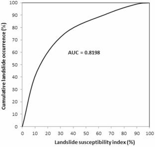
Landslide hazards are common problems in the rift escarpments and highlands of Ethiopia, causing damage to infrastructures, agricultural lands, and human lives. The Gedo-Dilb asphalt road, which crosses the western rift escarpments of northern Ethiopia, is frequently affected by landslides. The study aims to analyze spatial distributions of landslides and generate a landslide susceptibility map (LSM). The research work involved: (a) detailed inventory and characterization of landslides, and (b) evaluation of the landslides and their associations with different causative factors. Landslide inventory of the area was produced using Google Earth imagery, aerial photos, and intensive field campaigns. Accordingly, a total of 103 landslides were inventoried, encompassing an area of 8.44 km2. The main landslide types found in the area are rockfalls, debris/earth flows, and debris/earth slides. Seven causative factors were identified and used for landslide susceptibility mapping, namely: distance to stream, slope gradient, distance to road, land use land cover, lithology, plan and profile curvatures. Analytical hierarchy process (AHP) approach was used, and the model was validated using the area under the receiver operating characteristic (ROC) curve. The area under the curve (AUC) value was found to be 0.8198, indicating very good prediction of landslide susceptibility in the study area. It was observed that 75.12% of the inventoried landslides fall in the high and very high susceptibility zones. The AHP weight result revealed that slope gradient, lithology, and distance to stream played a major role in landslide occurrences. The resulting map would be important for regional spatial planning and future infrastructure development.
期刊介绍:
Engineering geology is defined in the statutes of the IAEG as the science devoted to the investigation, study and solution of engineering and environmental problems which may arise as the result of the interaction between geology and the works or activities of man, as well as of the prediction of and development of measures for the prevention or remediation of geological hazards. Engineering geology embraces:
• the applications/implications of the geomorphology, structural geology, and hydrogeological conditions of geological formations;
• the characterisation of the mineralogical, physico-geomechanical, chemical and hydraulic properties of all earth materials involved in construction, resource recovery and environmental change;
• the assessment of the mechanical and hydrological behaviour of soil and rock masses;
• the prediction of changes to the above properties with time;
• the determination of the parameters to be considered in the stability analysis of engineering works and earth masses.


 求助内容:
求助内容: 应助结果提醒方式:


