基于Sentinel-2和SRTM-DEM的AVIRIS-NG高光谱和多光谱数据的DTPA可提取微量营养素数字制图
IF 8.9
1区 农林科学
Q1 AGRICULTURE, MULTIDISCIPLINARY
引用次数: 0
摘要
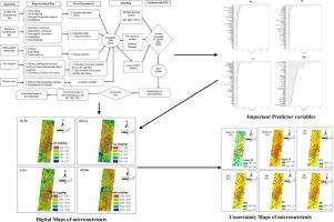
土壤养分的实时评估和预测是土壤养分精确管理的基础。受地形属性影响的土壤养分数字制图为特定地点的养分管理提供了一种很有前途的方法。虽然已分别利用多光谱和高光谱遥感数据进行土壤养分的数字制图,但将这两种数据类型整合为土壤养分,特别是土壤微量养分,仍未得到探索。因此,本研究试图通过整合Sentinel-2多光谱数据,提高对印度纳格浦尔地区Katol区块四种重要的二乙烯三胺五乙酸(DTPA)可提取微量元素阳离子锌(Zn)、铜(Cu)、铁(Fe)和锰(Mn)的预测准确性和可靠性。下一代机载可见红外成像光谱仪(AVIRIS-NG)的高光谱数据,以及航天飞机雷达地形任务(SRTM)数字高程模型(DEM)数据,土壤和气候数据以及三种机器学习(ML)模型。之所以选择这四种微量元素进行数字制图,是因为它们在植物生长发育中起着至关重要的作用,而且在高产品种的集约栽培下,它们的持续耗竭可能对研究区作物生产力和土壤健康产生不利影响。在机载高光谱采集过程中,利用AVIRIS-NG采集了132个地理参考表层土壤样品。利用随机森林(RF)、分位数随机森林(QRF)和Cubist三种ML模型,结合多光谱、高光谱、土壤和气候数据,在实验室和实验室生成的数据中分析微量营养素,以预测和绘制这四种关键微量营养素。通过对验证数据集的预测,发现RF模型在微量营养素预测方面具有较好的应用前景。由于RF模型表现出优异的性能,它被用于绘制这四种微量营养素。该模型预测Zn、Cu、Fe和Mn的决定系数(R2)分别为0.71、0.65、0.62和0.63。该研究利用了8种不同类型的数据集,并将它们应用于每个模型,结果表明,与单独使用单个数据集相比,多光谱、高光谱、土壤和气候数据集的组合使用提高了微量营养素的预测精度。研究还发现,土壤变量即土壤pH值是影响土壤微量元素预测的最大变量,尤其是对Zn、Cu和Fe的预测。此外,高光谱变量(Zn、Fe的PC2、Mn的PC1和PC3、Cu的PC6和PC7)对于预测和绘制土壤有效微量元素至关重要。此外,除土壤和高光谱变量外,dem衍生变量(山谷深度、海拔等)在预测微量元素(尤其是Mn)方面也很重要。通过置信度和预测区间以及标准偏差和标准误差评估的预测不确定性表明,锌和铜的预测不确定性较低,但铁和锰的预测不确定性略高,表明需要额外的土壤采样以获得更可靠的估计。因此,本研究强调,通过将多光谱和高光谱遥感数据与地形、土壤和气候数据相结合,可以提高微量营养素的可预测性,为研究地区的微量营养素精确管理提供有价值的微量营养素数字地图。本文章由计算机程序翻译,如有差异,请以英文原文为准。
Digital mapping of DTPA extractable micronutrients using combined AVIRIS-NG hyperspectral and multispectral data of Sentinel-2 and SRTM-DEM
Real-time assessment and prediction of soil nutrients are essential for precision soil nutrient management. Digital mapping of soil nutrients, influenced by topographical attributes, offers a promising approach for site-specific nutrient management. Although, multispectral and hyperspectral remote sensing data have been utilized separately for the digital mapping of soil nutrients, the integration of both data types for soil nutrients especially for soil micronutrients remains unexplored. Therefore, this study attempted to enhance the accuracy and reliability of predicting four important Diethylene Triamine Pentaacetic Acid (DTPA) extractable micronutrient cations such as zinc (Zn), copper (Cu), iron (Fe), and manganese (Mn) in the Katol block of Nagpur district, Maharashtra, India by integrating multispectral data of Sentinel-2, and hyperspectral data of Airborne Visible Infrared Imaging Spectrometer-Next Generation (AVIRIS-NG) along with the Shuttle Radar Topographic Mission (SRTM) digital elevation model (DEM) data, soil and climatic data with three machine learning (ML) models. These four micronutrients were selected for digital mapping owing to their crucial roles in plant growth and development, and their continuous depletion under intensive cultivation of high-yielding varieties, which may adversely affect crop productivity and soil health in the study area. 132 georeferenced surface soil samples were collected during airborne hyperspectral spectra acquisition by the AVIRIS-NG. Micronutrients were analysed in laboratory and lab-generated data combined with multispectral, hyperspectral, soil and climatic data with the help of three ML models viz. Random Forest (RF), Quantile Random Forest (QRF) and Cubist for predicting and mapping of those four key micronutrients. Based on the prediction performances especially in the validation dataset, the RF model was found more promising in comparison to other models in micronutrient prediction. Since the RF model demonstrated superior performance, it was utilized for mapping those four micronutrients. This RF model demonstrated moderate to satisfactory accuracy, with the value of the coefficient of determination (R2) 0.71, 0.65, 0.62 and 0.63 for Zn, Cu, Fe, and Mn prediction respectively. The study utilized eight different types of datasets and applied them to each model and it was revealed that the combined use of multispectral, hyperspectral, soil and climatic datasets improved the prediction accuracy of micronutrients compared to using each dataset individually. The study also revealed that soil variable i.e., soil pH was the most influential variable for soil micronutrient especially for Zn, Cu and Fe predictions. Next to this, hyperspectral variables (PC2 for Zn, Fe, PC1, and PC3 for Mn, and PC6, and PC7 for Cu) were found crucial in predicting and mapping soil-available micronutrients. Furthermore, it was observed that after soil and hyperspectral variables, DEM-derived variables (valley depth, elevation etc.) were also found important in predicting micronutrients particularly for Mn. Prediction uncertainties, assessed through confidence and prediction intervals as well as standard deviation and standard error, were lower for Zn and Cu, but slightly higher for Fe and Mn, indicating areas needing additional soil sampling for more reliable estimation. Thus, this study underscores the enhanced predictability of micronutrients, achieved by integrating multispectral and hyperspectral remote sensing data with terrain, soil and climatic data, providing valuable digital maps of micronutrients for precision micronutrient management in the study area.
求助全文
通过发布文献求助,成功后即可免费获取论文全文。
去求助
来源期刊

Computers and Electronics in Agriculture
工程技术-计算机:跨学科应用
CiteScore
15.30
自引率
14.50%
发文量
800
审稿时长
62 days
期刊介绍:
Computers and Electronics in Agriculture provides international coverage of advancements in computer hardware, software, electronic instrumentation, and control systems applied to agricultural challenges. Encompassing agronomy, horticulture, forestry, aquaculture, and animal farming, the journal publishes original papers, reviews, and applications notes. It explores the use of computers and electronics in plant or animal agricultural production, covering topics like agricultural soils, water, pests, controlled environments, and waste. The scope extends to on-farm post-harvest operations and relevant technologies, including artificial intelligence, sensors, machine vision, robotics, networking, and simulation modeling. Its companion journal, Smart Agricultural Technology, continues the focus on smart applications in production agriculture.
 求助内容:
求助内容: 应助结果提醒方式:


