Hande Demirel, Ayşenur Koçyiğit, Ben Alpagut, Damla Muhcu
{"title":"利用先进的三维地理信息系统(GIS)分析评估正能量区(PED)的太阳能潜力。","authors":"Hande Demirel, Ayşenur Koçyiğit, Ben Alpagut, Damla Muhcu","doi":"10.12688/openreseurope.19075.2","DOIUrl":null,"url":null,"abstract":"<p><strong>Background: </strong>The Positive Energy District (PED) concept aims to transform urban areas into carbon-neutral and zero-energy communities by reducing energy consumption and increasing renewable energy production. However, challenges remain in making effective decisions, including inconsistent data sources, difficulties in collaboration among stakeholders, and the need to merge interdisciplinary technical and scientific knowledge. Hence, GIS-based frameworks offer mature solutions to address such issues.</p><p><strong>Methods: </strong>This study introduces a three-dimensional (3D) GIS-based framework designed to improve decision-making in PEDs, with a particular focus on spatiotemporal analyses of solar energy potential. The rationale behind selecting solar energy is the high potential of urban areas for suitability, as well as the legal and technical constraints associated with wind and hydro energy production within densely populated areas and built-up areas. The literature review showed that the combined use of 3D GIS and PED concepts has not yet been widely explored, despite the significant potential that exists. The developed framework were deployed and tested in the case study area - the Caferağa neighborhood of Kadıköy, Türkiye. In order to test and validate the achieved results, various platforms are utilized and compared.</p><p><strong>Results: </strong>The 3D GIS-based framework demonstrated several advantages over traditional systems. It utilized spatial data, including high-resolution 3D building models, to assess solar potential, employing and comparing various spatial tools. Comprehensive analyses were performed to assess the exposure of buildings to sunlight during different seasons and to evaluate the shading effects encountered throughout the day. The analysis of sun hour revealed that only 5% of the entire work area received more than nine hours of sunlight during the winter. Additionally, when evaluating the solar potential, a 22.29% discrepancy was found within utilized platforms.</p><p><strong>Conclusion: </strong>The achieved results are promising, where co-creation, co-design- and co-implementation could be performed collaboratively via designed platform that seamlessly integrate data, functions, necessary tools and expertise. The results indicate that 3D spatial analyses promote the potential for solar energy and aid decision-makers in the complex processes of designing and expanding PEDs.</p>","PeriodicalId":74359,"journal":{"name":"Open research Europe","volume":"5 ","pages":"81"},"PeriodicalIF":0.0000,"publicationDate":"2025-07-14","publicationTypes":"Journal Article","fieldsOfStudy":null,"isOpenAccess":false,"openAccessPdf":"https://www.ncbi.nlm.nih.gov/pmc/articles/PMC12365597/pdf/","citationCount":"0","resultStr":"{\"title\":\"Evaluating the solar energy potential for Positive Energy Districts (PED) through advanced 3D Geographic Information System (GIS) analysis.\",\"authors\":\"Hande Demirel, Ayşenur Koçyiğit, Ben Alpagut, Damla Muhcu\",\"doi\":\"10.12688/openreseurope.19075.2\",\"DOIUrl\":null,\"url\":null,\"abstract\":\"<p><strong>Background: </strong>The Positive Energy District (PED) concept aims to transform urban areas into carbon-neutral and zero-energy communities by reducing energy consumption and increasing renewable energy production. However, challenges remain in making effective decisions, including inconsistent data sources, difficulties in collaboration among stakeholders, and the need to merge interdisciplinary technical and scientific knowledge. Hence, GIS-based frameworks offer mature solutions to address such issues.</p><p><strong>Methods: </strong>This study introduces a three-dimensional (3D) GIS-based framework designed to improve decision-making in PEDs, with a particular focus on spatiotemporal analyses of solar energy potential. The rationale behind selecting solar energy is the high potential of urban areas for suitability, as well as the legal and technical constraints associated with wind and hydro energy production within densely populated areas and built-up areas. The literature review showed that the combined use of 3D GIS and PED concepts has not yet been widely explored, despite the significant potential that exists. The developed framework were deployed and tested in the case study area - the Caferağa neighborhood of Kadıköy, Türkiye. In order to test and validate the achieved results, various platforms are utilized and compared.</p><p><strong>Results: </strong>The 3D GIS-based framework demonstrated several advantages over traditional systems. It utilized spatial data, including high-resolution 3D building models, to assess solar potential, employing and comparing various spatial tools. Comprehensive analyses were performed to assess the exposure of buildings to sunlight during different seasons and to evaluate the shading effects encountered throughout the day. The analysis of sun hour revealed that only 5% of the entire work area received more than nine hours of sunlight during the winter. Additionally, when evaluating the solar potential, a 22.29% discrepancy was found within utilized platforms.</p><p><strong>Conclusion: </strong>The achieved results are promising, where co-creation, co-design- and co-implementation could be performed collaboratively via designed platform that seamlessly integrate data, functions, necessary tools and expertise. The results indicate that 3D spatial analyses promote the potential for solar energy and aid decision-makers in the complex processes of designing and expanding PEDs.</p>\",\"PeriodicalId\":74359,\"journal\":{\"name\":\"Open research Europe\",\"volume\":\"5 \",\"pages\":\"81\"},\"PeriodicalIF\":0.0000,\"publicationDate\":\"2025-07-14\",\"publicationTypes\":\"Journal Article\",\"fieldsOfStudy\":null,\"isOpenAccess\":false,\"openAccessPdf\":\"https://www.ncbi.nlm.nih.gov/pmc/articles/PMC12365597/pdf/\",\"citationCount\":\"0\",\"resultStr\":null,\"platform\":\"Semanticscholar\",\"paperid\":null,\"PeriodicalName\":\"Open research Europe\",\"FirstCategoryId\":\"1085\",\"ListUrlMain\":\"https://doi.org/10.12688/openreseurope.19075.2\",\"RegionNum\":0,\"RegionCategory\":null,\"ArticlePicture\":[],\"TitleCN\":null,\"AbstractTextCN\":null,\"PMCID\":null,\"EPubDate\":\"2025/1/1 0:00:00\",\"PubModel\":\"eCollection\",\"JCR\":\"\",\"JCRName\":\"\",\"Score\":null,\"Total\":0}","platform":"Semanticscholar","paperid":null,"PeriodicalName":"Open research Europe","FirstCategoryId":"1085","ListUrlMain":"https://doi.org/10.12688/openreseurope.19075.2","RegionNum":0,"RegionCategory":null,"ArticlePicture":[],"TitleCN":null,"AbstractTextCN":null,"PMCID":null,"EPubDate":"2025/1/1 0:00:00","PubModel":"eCollection","JCR":"","JCRName":"","Score":null,"Total":0}
Evaluating the solar energy potential for Positive Energy Districts (PED) through advanced 3D Geographic Information System (GIS) analysis.
Background: The Positive Energy District (PED) concept aims to transform urban areas into carbon-neutral and zero-energy communities by reducing energy consumption and increasing renewable energy production. However, challenges remain in making effective decisions, including inconsistent data sources, difficulties in collaboration among stakeholders, and the need to merge interdisciplinary technical and scientific knowledge. Hence, GIS-based frameworks offer mature solutions to address such issues.
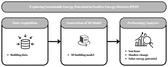
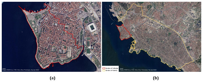
Methods: This study introduces a three-dimensional (3D) GIS-based framework designed to improve decision-making in PEDs, with a particular focus on spatiotemporal analyses of solar energy potential. The rationale behind selecting solar energy is the high potential of urban areas for suitability, as well as the legal and technical constraints associated with wind and hydro energy production within densely populated areas and built-up areas. The literature review showed that the combined use of 3D GIS and PED concepts has not yet been widely explored, despite the significant potential that exists. The developed framework were deployed and tested in the case study area - the Caferağa neighborhood of Kadıköy, Türkiye. In order to test and validate the achieved results, various platforms are utilized and compared.
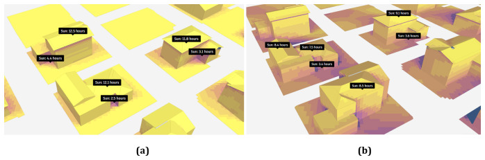
Results: The 3D GIS-based framework demonstrated several advantages over traditional systems. It utilized spatial data, including high-resolution 3D building models, to assess solar potential, employing and comparing various spatial tools. Comprehensive analyses were performed to assess the exposure of buildings to sunlight during different seasons and to evaluate the shading effects encountered throughout the day. The analysis of sun hour revealed that only 5% of the entire work area received more than nine hours of sunlight during the winter. Additionally, when evaluating the solar potential, a 22.29% discrepancy was found within utilized platforms.
Conclusion: The achieved results are promising, where co-creation, co-design- and co-implementation could be performed collaboratively via designed platform that seamlessly integrate data, functions, necessary tools and expertise. The results indicate that 3D spatial analyses promote the potential for solar energy and aid decision-makers in the complex processes of designing and expanding PEDs.

 求助内容:
求助内容: 应助结果提醒方式:


