{"title":"基于火灾识别与地理空间数据分析的火学研究进展","authors":"V. M. Pavleychik","doi":"10.1134/S2079096124700549","DOIUrl":null,"url":null,"abstract":"<p>Wildfires are a typical phenomenon for the steppes of Northern Eurasia and a threat to environmental security at the regional and global levels. To understand the causes of fires, the author proposes a methodology for mapping fire sites and subsequent data analysis using the example of a territory located in the steppes of the Southern Trans-Urals. Source materials for the data were collected using Landsat (1984–2021) and MODIS (2000–2021) satellite images, geospatial data based on them, morphometric features of burnt areas, and meteorological data at the time of fire spread. For the period 1984–2021, 738 fire sites were identified and their density was calculated. Classification was carried out in relation to their position as anthropogenic and natural objects. It was found that 51.6% of outbreaks were confined to poorly developed agricultural lands (pastures, hayfields, and fallow lands of different ages), 21.8% to highways, and 13.6% to cultivated arable lands. A sharp deterioration in the fire situation has been observed since 1999 to the present day, which is due to a reduction in agricultural production, restoration of vegetation cover of degraded pastures, and defragmentation of arable land. A regional feature is the lack of a tendency towards a reduction in fires due to the onset of a low-water period (2012–2021), accompanied by the drying up of the vast lake basins of the Southern Trans-Urals and Turgai. The listed factors caused the fires to spread more widely, while the main locations of the outbreaks remained unchanged. It was determined that, despite the worsening fire situation, since 2005 the effectiveness of fire prevention measures taken to protect the Ashchisayskaya Steppe Nature Reserve has increased. The approaches developed for identifying the position and analyzing the distribution of fire sources can be recommended for assessing pyrogenic threats and optimizing fire prevention measures.</p>","PeriodicalId":44316,"journal":{"name":"Arid Ecosystems","volume":"15 1","pages":"26 - 35"},"PeriodicalIF":0.6000,"publicationDate":"2025-09-02","publicationTypes":"Journal Article","fieldsOfStudy":null,"isOpenAccess":false,"openAccessPdf":"","citationCount":"0","resultStr":"{\"title\":\"Development of Pyrological Research Based on the Results of Fire Identification and Analysis of Geospatial Data\",\"authors\":\"V. M. Pavleychik\",\"doi\":\"10.1134/S2079096124700549\",\"DOIUrl\":null,\"url\":null,\"abstract\":\"<p>Wildfires are a typical phenomenon for the steppes of Northern Eurasia and a threat to environmental security at the regional and global levels. To understand the causes of fires, the author proposes a methodology for mapping fire sites and subsequent data analysis using the example of a territory located in the steppes of the Southern Trans-Urals. Source materials for the data were collected using Landsat (1984–2021) and MODIS (2000–2021) satellite images, geospatial data based on them, morphometric features of burnt areas, and meteorological data at the time of fire spread. For the period 1984–2021, 738 fire sites were identified and their density was calculated. Classification was carried out in relation to their position as anthropogenic and natural objects. It was found that 51.6% of outbreaks were confined to poorly developed agricultural lands (pastures, hayfields, and fallow lands of different ages), 21.8% to highways, and 13.6% to cultivated arable lands. A sharp deterioration in the fire situation has been observed since 1999 to the present day, which is due to a reduction in agricultural production, restoration of vegetation cover of degraded pastures, and defragmentation of arable land. A regional feature is the lack of a tendency towards a reduction in fires due to the onset of a low-water period (2012–2021), accompanied by the drying up of the vast lake basins of the Southern Trans-Urals and Turgai. The listed factors caused the fires to spread more widely, while the main locations of the outbreaks remained unchanged. It was determined that, despite the worsening fire situation, since 2005 the effectiveness of fire prevention measures taken to protect the Ashchisayskaya Steppe Nature Reserve has increased. The approaches developed for identifying the position and analyzing the distribution of fire sources can be recommended for assessing pyrogenic threats and optimizing fire prevention measures.</p>\",\"PeriodicalId\":44316,\"journal\":{\"name\":\"Arid Ecosystems\",\"volume\":\"15 1\",\"pages\":\"26 - 35\"},\"PeriodicalIF\":0.6000,\"publicationDate\":\"2025-09-02\",\"publicationTypes\":\"Journal Article\",\"fieldsOfStudy\":null,\"isOpenAccess\":false,\"openAccessPdf\":\"\",\"citationCount\":\"0\",\"resultStr\":null,\"platform\":\"Semanticscholar\",\"paperid\":null,\"PeriodicalName\":\"Arid Ecosystems\",\"FirstCategoryId\":\"1085\",\"ListUrlMain\":\"https://link.springer.com/article/10.1134/S2079096124700549\",\"RegionNum\":0,\"RegionCategory\":null,\"ArticlePicture\":[],\"TitleCN\":null,\"AbstractTextCN\":null,\"PMCID\":null,\"EPubDate\":\"\",\"PubModel\":\"\",\"JCR\":\"Q4\",\"JCRName\":\"ECOLOGY\",\"Score\":null,\"Total\":0}","platform":"Semanticscholar","paperid":null,"PeriodicalName":"Arid Ecosystems","FirstCategoryId":"1085","ListUrlMain":"https://link.springer.com/article/10.1134/S2079096124700549","RegionNum":0,"RegionCategory":null,"ArticlePicture":[],"TitleCN":null,"AbstractTextCN":null,"PMCID":null,"EPubDate":"","PubModel":"","JCR":"Q4","JCRName":"ECOLOGY","Score":null,"Total":0}
Development of Pyrological Research Based on the Results of Fire Identification and Analysis of Geospatial Data
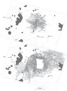
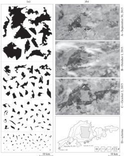
Wildfires are a typical phenomenon for the steppes of Northern Eurasia and a threat to environmental security at the regional and global levels. To understand the causes of fires, the author proposes a methodology for mapping fire sites and subsequent data analysis using the example of a territory located in the steppes of the Southern Trans-Urals. Source materials for the data were collected using Landsat (1984–2021) and MODIS (2000–2021) satellite images, geospatial data based on them, morphometric features of burnt areas, and meteorological data at the time of fire spread. For the period 1984–2021, 738 fire sites were identified and their density was calculated. Classification was carried out in relation to their position as anthropogenic and natural objects. It was found that 51.6% of outbreaks were confined to poorly developed agricultural lands (pastures, hayfields, and fallow lands of different ages), 21.8% to highways, and 13.6% to cultivated arable lands. A sharp deterioration in the fire situation has been observed since 1999 to the present day, which is due to a reduction in agricultural production, restoration of vegetation cover of degraded pastures, and defragmentation of arable land. A regional feature is the lack of a tendency towards a reduction in fires due to the onset of a low-water period (2012–2021), accompanied by the drying up of the vast lake basins of the Southern Trans-Urals and Turgai. The listed factors caused the fires to spread more widely, while the main locations of the outbreaks remained unchanged. It was determined that, despite the worsening fire situation, since 2005 the effectiveness of fire prevention measures taken to protect the Ashchisayskaya Steppe Nature Reserve has increased. The approaches developed for identifying the position and analyzing the distribution of fire sources can be recommended for assessing pyrogenic threats and optimizing fire prevention measures.
期刊介绍:
Arid Ecosystems publishes original scientific research articles on desert and semidesert ecosystems and environment:systematic studies of arid territories: climate changes, water supply of territories, soils as ecological factors of ecosystems state and dynamics in different scales (from local to global);systematic studies of arid ecosystems: composition and structure, diversity, ecology; paleohistory; dynamics under anthropogenic and natural factors impact, including climate changes; studying of bioresources and biodiversity, and development of the mapping methods;arid ecosystems protection: development of the theory and methods of degradation prevention and monitoring; desert ecosystems rehabilitation;problems of desertification: theoretical and practical issues of modern aridization processes under anthropogenic impact and global climate changes.
 求助内容:
求助内容: 应助结果提醒方式:


