基于GIS和多准则决策分析的沿海浅湖水质监测

IF 5.6 Q1 ENVIRONMENTAL SCIENCES
Anja Batina, Ante Šiljeg
{"title":"基于GIS和多准则决策分析的沿海浅湖水质监测","authors":"Anja Batina,&nbsp;Ante Šiljeg","doi":"10.1016/j.indic.2025.100881","DOIUrl":null,"url":null,"abstract":"<div><div>Water quality decline is a critical global issue affecting both aquatic ecosystems and human health. This study focuses on Vrana Lake, a coastal shallow lake in Dalmatia, Croatia, which is subject to seasonal water level fluctuations, salinization from the Adriatic Sea, and various anthropogenic and environmental pressures. To evaluate and improve water quality monitoring, a spatial assessment was conducted using a Geographic Information System-based Multi-Criteria Decision Analysis (GIS-MCDA) integrated with the Fuzzy Analytical Hierarchy Process (F-AHP). The analysis incorporated multiple criteria including electrical conductivity, turbidity, dissolved oxygen, water temperature, distance from water resources, distance from land nutrient runoff, distance from environmental pollutants, wind, precipitation, and air temperature, using data collected from July 2023 to June 2024. The methodology included standardization of criteria in GIS software, weighting through F-AHP, and a sensitivity analysis using 1000 Monte Carlo simulations to assess model robustness. Results revealed spatial variations in water quality, with lower quality observed in the northwestern and southern regions, influenced by anthropogenic activities and seawater intrusion. An optimized monitoring network of seven stations was developed based on Jenks natural breaks classification, ensuring comprehensive lake coverage and efficient representation of all water quality classes. Three existing stations and two from previous networks were incorporated into the new network, with two additional stations proposed to maintain consistent spatial distribution. This study provides an adaptable decision support framework for improving water quality monitoring and management in coastal shallow lakes, offering a strategic approach to early eutrophication warning systems and informed resource planning.</div></div>","PeriodicalId":36171,"journal":{"name":"Environmental and Sustainability Indicators","volume":"28 ","pages":"Article 100881"},"PeriodicalIF":5.6000,"publicationDate":"2025-08-25","publicationTypes":"Journal Article","fieldsOfStudy":null,"isOpenAccess":false,"openAccessPdf":"","citationCount":"0","resultStr":"{\"title\":\"Enhancing water quality monitoring in a coastal shallow lake using GIS and multi-criteria decision analysis\",\"authors\":\"Anja Batina,&nbsp;Ante Šiljeg\",\"doi\":\"10.1016/j.indic.2025.100881\",\"DOIUrl\":null,\"url\":null,\"abstract\":\"<div><div>Water quality decline is a critical global issue affecting both aquatic ecosystems and human health. This study focuses on Vrana Lake, a coastal shallow lake in Dalmatia, Croatia, which is subject to seasonal water level fluctuations, salinization from the Adriatic Sea, and various anthropogenic and environmental pressures. To evaluate and improve water quality monitoring, a spatial assessment was conducted using a Geographic Information System-based Multi-Criteria Decision Analysis (GIS-MCDA) integrated with the Fuzzy Analytical Hierarchy Process (F-AHP). The analysis incorporated multiple criteria including electrical conductivity, turbidity, dissolved oxygen, water temperature, distance from water resources, distance from land nutrient runoff, distance from environmental pollutants, wind, precipitation, and air temperature, using data collected from July 2023 to June 2024. The methodology included standardization of criteria in GIS software, weighting through F-AHP, and a sensitivity analysis using 1000 Monte Carlo simulations to assess model robustness. Results revealed spatial variations in water quality, with lower quality observed in the northwestern and southern regions, influenced by anthropogenic activities and seawater intrusion. An optimized monitoring network of seven stations was developed based on Jenks natural breaks classification, ensuring comprehensive lake coverage and efficient representation of all water quality classes. Three existing stations and two from previous networks were incorporated into the new network, with two additional stations proposed to maintain consistent spatial distribution. This study provides an adaptable decision support framework for improving water quality monitoring and management in coastal shallow lakes, offering a strategic approach to early eutrophication warning systems and informed resource planning.</div></div>\",\"PeriodicalId\":36171,\"journal\":{\"name\":\"Environmental and Sustainability Indicators\",\"volume\":\"28 \",\"pages\":\"Article 100881\"},\"PeriodicalIF\":5.6000,\"publicationDate\":\"2025-08-25\",\"publicationTypes\":\"Journal Article\",\"fieldsOfStudy\":null,\"isOpenAccess\":false,\"openAccessPdf\":\"\",\"citationCount\":\"0\",\"resultStr\":null,\"platform\":\"Semanticscholar\",\"paperid\":null,\"PeriodicalName\":\"Environmental and Sustainability Indicators\",\"FirstCategoryId\":\"1085\",\"ListUrlMain\":\"https://www.sciencedirect.com/science/article/pii/S2665972725003022\",\"RegionNum\":0,\"RegionCategory\":null,\"ArticlePicture\":[],\"TitleCN\":null,\"AbstractTextCN\":null,\"PMCID\":null,\"EPubDate\":\"\",\"PubModel\":\"\",\"JCR\":\"Q1\",\"JCRName\":\"ENVIRONMENTAL SCIENCES\",\"Score\":null,\"Total\":0}","platform":"Semanticscholar","paperid":null,"PeriodicalName":"Environmental and Sustainability Indicators","FirstCategoryId":"1085","ListUrlMain":"https://www.sciencedirect.com/science/article/pii/S2665972725003022","RegionNum":0,"RegionCategory":null,"ArticlePicture":[],"TitleCN":null,"AbstractTextCN":null,"PMCID":null,"EPubDate":"","PubModel":"","JCR":"Q1","JCRName":"ENVIRONMENTAL SCIENCES","Score":null,"Total":0}
引用次数: 0

摘要

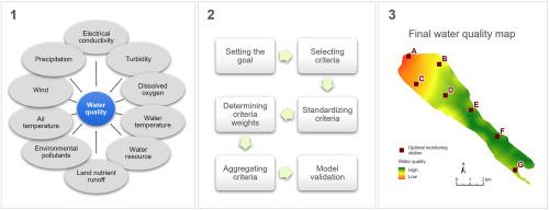
水质下降是影响水生生态系统和人类健康的重大全球性问题。本研究的重点是克罗地亚达尔马提亚的一个沿海浅湖Vrana湖,该湖受到季节性水位波动、亚得里亚海盐碱化以及各种人为和环境压力的影响。为了评价和改进水质监测,采用基于地理信息系统的多准则决策分析(GIS-MCDA)与模糊层次分析法(F-AHP)相结合的方法进行了空间评价。该分析采用了多种标准,包括电导率、浊度、溶解氧、水温、与水资源的距离、与土地养分径流的距离、与环境污染物的距离、风、降水和气温,使用了2023年7月至2024年6月收集的数据。方法包括GIS软件标准的标准化,通过F-AHP加权,以及使用1000个蒙特卡罗模拟来评估模型稳健性的敏感性分析。结果表明:受人为活动和海水入侵的影响,流域水质呈现出明显的空间差异,西北部和南部水质较差;基于Jenks自然断裂分类,优化了7个站点的监测网络,确保了湖泊的全面覆盖和所有水质等级的有效代表。三个现有站点和两个来自以前网络的站点被纳入新的网络,另外两个站点建议保持一致的空间分布。该研究为改善沿海浅湖水质监测和管理提供了适应性决策支持框架,为早期富营养化预警系统和知情资源规划提供了战略途径。
本文章由计算机程序翻译,如有差异,请以英文原文为准。

Enhancing water quality monitoring in a coastal shallow lake using GIS and multi-criteria decision analysis

Enhancing water quality monitoring in a coastal shallow lake using GIS and multi-criteria decision analysis
Water quality decline is a critical global issue affecting both aquatic ecosystems and human health. This study focuses on Vrana Lake, a coastal shallow lake in Dalmatia, Croatia, which is subject to seasonal water level fluctuations, salinization from the Adriatic Sea, and various anthropogenic and environmental pressures. To evaluate and improve water quality monitoring, a spatial assessment was conducted using a Geographic Information System-based Multi-Criteria Decision Analysis (GIS-MCDA) integrated with the Fuzzy Analytical Hierarchy Process (F-AHP). The analysis incorporated multiple criteria including electrical conductivity, turbidity, dissolved oxygen, water temperature, distance from water resources, distance from land nutrient runoff, distance from environmental pollutants, wind, precipitation, and air temperature, using data collected from July 2023 to June 2024. The methodology included standardization of criteria in GIS software, weighting through F-AHP, and a sensitivity analysis using 1000 Monte Carlo simulations to assess model robustness. Results revealed spatial variations in water quality, with lower quality observed in the northwestern and southern regions, influenced by anthropogenic activities and seawater intrusion. An optimized monitoring network of seven stations was developed based on Jenks natural breaks classification, ensuring comprehensive lake coverage and efficient representation of all water quality classes. Three existing stations and two from previous networks were incorporated into the new network, with two additional stations proposed to maintain consistent spatial distribution. This study provides an adaptable decision support framework for improving water quality monitoring and management in coastal shallow lakes, offering a strategic approach to early eutrophication warning systems and informed resource planning.
求助全文
通过发布文献求助,成功后即可免费获取论文全文。 去求助
来源期刊
Environmental and Sustainability Indicators
Environmental and Sustainability Indicators Environmental Science-Environmental Science (miscellaneous)
CiteScore
7.80
自引率
2.30%
发文量
49
审稿时长
57 days
×
引用
GB/T 7714-2015
复制
MLA
复制
APA
复制
导出至
BibTeX EndNote RefMan NoteFirst NoteExpress
×
提示
您的信息不完整,为了账户安全,请先补充。
现在去补充
×
提示
您因"违规操作"
具体请查看互助需知
我知道了
×
提示
确定
请完成安全验证×
copy
已复制链接
快去分享给好友吧!
我知道了
右上角分享
点击右上角分享
0
联系我们:info@booksci.cn Book学术提供免费学术资源搜索服务,方便国内外学者检索中英文文献。致力于提供最便捷和优质的服务体验。 Copyright © 2023 布克学术 All rights reserved.
京ICP备2023020795号-1
ghs 京公网安备 11010802042870号
Book学术文献互助
Book学术文献互助群
群 号:604180095
Book学术官方微信